File:Map of (Thibet) with Lhasa (Lassa) capitol and India (Hindoostan) with Calcutta capitol in 1839 from Mitchell's School Atlas LOC 2007633727-13 (cropped).jpg
Jump to navigation
Jump to search

Size of this preview: 518 × 599 pixels. Other resolutions: 207 × 240 pixels | 415 × 480 pixels | 915 × 1,058 pixels.
Original file (915 × 1,058 pixels, file size: 256 KB, MIME type: image/jpeg)
Captions
Captions
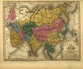
Map of (Thibet) with Lhasa (Lassa) capitol and India (Hindoostan) with Calcutta capitol in 1839 from Mitchell's School Atlas
Summary
[edit]| Description |
English: Also shows regional United States maps. Relief shown by hachures. Title and publisher information from Phillips, v. 5, p. 333, 1958. Prime meridians: Greenwich and Washington, D.C. Phillips, 6085 "Entered according to act of Congress in the year 1839 by S. Augustus Mitchell in the clerk's office of the District Court of Connecticut"--On each plate. Maps engraved by J.H. Young and W. Williams. Available also through the Library of Congress Web site as a raster image. On maps 3-18: Engraved to illustrate Mitchell's school and family atlas. Includes statistics. LC copy imperfect: Wanting cover. |
||
| Title | [Mitchell's school atlas]. | ||
| Shelf ID | G1019 .M66 1839 | ||
| Parent | https://www.loc.gov/resource/g3200m.gct00054/ | ||
| Sheet title | Asia | ||
| Date | |||
| Source | https://www.loc.gov/item/2007633727/ | ||
| Author | Mitchell, S. Augustus (Samuel Augustus); Young, J. H. (James Hamilton); Thomas, Cowperthwait & Co.; Mitchell, S. Augustus | ||
| Permission (Reusing this file) |
|
||
| Other versions |
|
||
| Location | United States | ||
| Part of | American Memory · General Maps · Catalog · Geography And Map Division | ||
| Subject | United States · Maps · Atlases |


_with_Lhasa_(Lassa)_capitol_and_India_(Hindoostan)_with_Calcutta_capitol_in_1839_from_Mitchell%27s_School_Atlas_LOC_2007633727-13_(cropped).jpg&action=edit§ion=1)
Licensing
[edit]_with_Lhasa_(Lassa)_capitol_and_India_(Hindoostan)_with_Calcutta_capitol_in_1839_from_Mitchell%27s_School_Atlas_LOC_2007633727-13_(cropped).jpg&action=edit§ion=2)
|
This is a faithful photographic reproduction of a two-dimensional, public domain work of art. The work of art itself is in the public domain for the following reason:
The official position taken by the Wikimedia Foundation is that "faithful reproductions of two-dimensional public domain works of art are public domain".
This photographic reproduction is therefore also considered to be in the public domain in the United States. In other jurisdictions, re-use of this content may be restricted; see Reuse of PD-Art photographs for details. | ||||
File history
Click on a date/time to view the file as it appeared at that time.
| Date/Time | Thumbnail | Dimensions | User | Comment | |
|---|---|---|---|---|---|
| current | 14:13, 28 March 2019 | | 915 × 1,058 (256 KB) | Tibet Nation (talk | contribs) | File:Mitchell's school atlas LOC 2007633727-13.jpg cropped 73 % horizontally, 62 % vertically using CropTool with lossless mode. |
You cannot overwrite this file.
File usage on Commons
The following 4 pages use this file:
_with_Lhasa_(Lassa)_capitol_and_India_(Hindoostan)_with_Calcutta_capitol_in_1839_from_Mitchell%27s_School_Atlas_LOC_2007633727-13_(cropped).jpg&oldid=720350844)
Categories:
- Maps in the Library of Congress
- Mitchell's school atlas
- 19th-century maps of Tibet
- 19th-century maps of India
- Maps of Lhasa
- 19th-century maps of Nepal
- Old maps of Bhutan
- Old maps of Myanmar
- Old maps of Ladakh
- Maps of the Indus River
- Maps of the Brahmaputra
- Ayeyarwady River
- Maps of the Salween River
- Maps of the Mekong
- Maps of the Yangtze River
- Yellow River in Lanzhou
- Qinghai Lake
- 1839 maps of Asia