File:Map of Africa in 1939.svg
Jump to navigation
Jump to search

Size of this PNG preview of this SVG file: 365 × 365 pixels. Other resolutions: 240 × 240 pixels | 480 × 480 pixels | 768 × 768 pixels | 1,024 × 1,024 pixels | 2,048 × 2,048 pixels.
Original file (SVG file, nominally 365 × 365 pixels, file size: 1.53 MB)
Captions
Captions
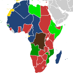
Map showing the European colonial empires in Africa in 1939.
Summary[edit]
| Description |
English: Map showing the European colonial empires in Africa in 1939.
Belgian colonial empire
British colonial empire
French colonial empire
Italian colonial empire
Portuguese colonial empire
Spanish colonial empire |
| Date | |
| Source | Own work (based upon: File:Map of Africa in 1939.png + File:1937 world map (Winkel tripel projection).svg) |
| Author | Cukrakalnis |
.svg)
Licensing[edit]
I, the copyright holder of this work, hereby publish it under the following license:
This file is licensed under the Creative Commons Attribution-Share Alike 4.0 International license.
- You are free:
- to share – to copy, distribute and transmit the work
- to remix – to adapt the work
- Under the following conditions:
- attribution – You must give appropriate credit, provide a link to the license, and indicate if changes were made. You may do so in any reasonable manner, but not in any way that suggests the licensor endorses you or your use.
- share alike – If you remix, transform, or build upon the material, you must distribute your contributions under the same or compatible license as the original.
File history
Click on a date/time to view the file as it appeared at that time.
| Date/Time | Thumbnail | Dimensions | User | Comment | |
|---|---|---|---|---|---|
| current | 19:34, 15 February 2023 | | 365 × 365 (1.53 MB) | +JMJ+ (talk | contribs) | improvements |
| 18:42, 15 February 2023 |  | 365 × 365 (1.47 MB) | +JMJ+ (talk | contribs) | Uploaded own work with UploadWizard |
You cannot overwrite this file.
File usage on Commons
The following page uses this file:
File usage on other wikis
The following other wikis use this file:
- Usage on af.wikipedia.org
- Usage on ast.wikipedia.org
- Usage on el.wikipedia.org
- Usage on en.wikipedia.org
- Usage on fr.wikipedia.org
- Usage on nl.wikipedia.org
- Usage on tum.wikipedia.org