File:Map of Alabama NA.png
Zur Navigation springen
Zur Suche springen

Greßi vu däre Vorschau: 776 × 600 Pixel. Wyteri Ufflösige: 311 × 240 Pixel | 621 × 480 Pixel | 994 × 768 Pixel | 1.280 × 989 Pixel | 2.122 × 1.640 Pixel.
Originaldatei (2.122 × 1.640 Pixel, Dateigrößi: 1,61 MB, MIME-Typ: image/png)
Bildtexte
Kurzbeschreibungen
Ergänze eine einzeilige Erklärung, was diese Datei darstellt.
Bschryybig[ändere]
| Bschryybig |
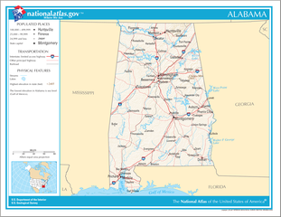
English: Map of the U.S. state of Alabama, with full legend area, copied from the National Atlas of the United States in high resolution form (1.61 megabytes). |
| Datum | (uploaded on 14. Ougschte 2006) |
| Quälle | |
| Urheber | National Atlas of the United States (uploaded by User:Huebi) |
| Anderi Versione |
The map has some related variations:
|
Lizänzierig[ändere]
Diese Karte stammt aus einer Ausgabe des National Atlas of the United States. Wie fast alle Arbeiten der Regierung der Vereinigten Staaten sind Arbeiten des National Atlas in den USA gemeinfrei.
Online-Zugang: NationalAtlas.gov | Gedruckte Ausgabe von 1970: Library of Congress, Perry-Castañeda Library
|
Dateiversione
Klick uf e Zytpunkt zu aazeige, wie s dert usgsäh het.
| Version vom | Vorschaubild | Mäß | Benutzer | Kommentar | |
|---|---|---|---|---|---|
| aktuell | 20:08, 14. Aug. 2006 | | 2.122 × 1.640 (1,61 MB) | Huebi~commonswiki (Diskussion | Byträg) | {{Information| |Description=Map of Alabama |Source=[http://www.nationalatlas.gov National Atlas] }} Category:Maps of the United States Category:Maps of Alabama {{PD-USGov-Atlas}} |
Du chasch die Datei nit iberschryybe.
Verwändig vu dr Datei
Kei Artikel bruucht die Datei.
Wältwyti Dateinutzig
Die andere Wikis bruche die Datei:
- Gebruch uf als.wikipedia.org
- Gebruch uf bs.wikipedia.org
- Gebruch uf ca.wikipedia.org
- Gebruch uf de.wikipedia.org
- Gebruch uf en.wikipedia.org
- Gebruch uf hi.wikipedia.org
- Gebruch uf hr.wiktionary.org
- Gebruch uf hsb.wikipedia.org
- Gebruch uf hu.wikipedia.org
- Gebruch uf ilo.wikipedia.org
- Gebruch uf it.wikipedia.org
- Gebruch uf ja.wikipedia.org
- Gebruch uf ko.wikipedia.org
- Gebruch uf no.wikipedia.org
- Gebruch uf or.wikipedia.org
- Gebruch uf simple.wikipedia.org
- Gebruch uf si.wikipedia.org
- Gebruch uf uz.wikipedia.org
- Gebruch uf zea.wikipedia.org