File:Map of Amsterdam with the new city extension 7.jpg
Jump to navigation
Jump to search
Size of this preview: 799 × 223 pixels. Other resolutions: 320 × 89 pixels | 640 × 179 pixels | 1,024 × 286 pixels | 1,280 × 358 pixels | 6,547 × 1,829 pixels.
Original file (6,547 × 1,829 pixels, file size: 4.16 MB, MIME type: image/jpeg)
Captions
Captions
Add a one-line explanation of what this file represents
Summary
[edit]| Description |
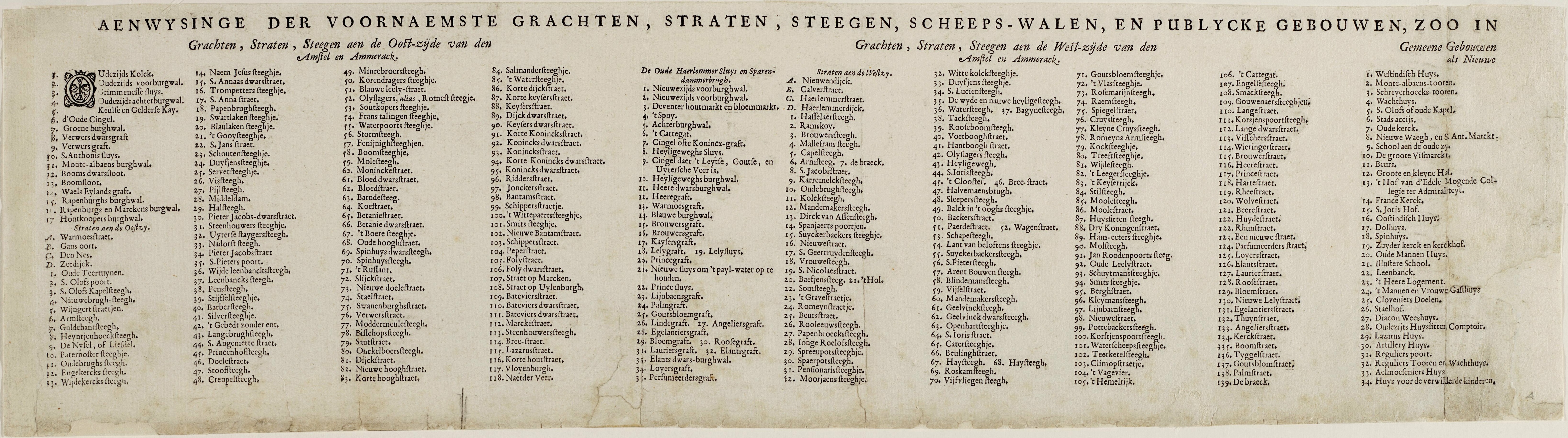
Nederlands: Map of Amsterdam with the new city extension / Plattegrond van Amsterdam met de nieuwe stadsuitleg. Gravure. |
| Date | |
| Source | |
| Author | Julius Milheuser, after Daniël Stalpaert |

Licensing
[edit]
|
This work is in the public domain in its country of origin and other countries and areas where the copyright term is the author's life plus 70 years or fewer. This work is in the public domain in the United States because it was published (or registered with the U.S. Copyright Office) before January 1, 1929. | |
| This file has been identified as being free of known restrictions under copyright law, including all related and neighboring rights. | |
File history
Click on a date/time to view the file as it appeared at that time.
| Date/Time | Thumbnail | Dimensions | User | Comment | |
|---|---|---|---|---|---|
| current | 11:48, 25 June 2023 | 6,547 × 1,829 (4.16 MB) | Vincent Steenberg (talk | contribs) | Uploaded a work by Julius Milheuser, after Daniël Stalpaert from {{extracted from|Map of Amsterdam with the new city extension 7-9.jpg}} with UploadWizard |
You cannot overwrite this file.
File usage on Commons
There are no pages that use this file.
File usage on other wikis
The following other wikis use this file:
- Usage on nl.wikipedia.org