File:Map of Ancient Rome 271 AD.svg
ナビゲーションに移動
検索に移動

この SVG ファイルのこの PNG プレビューのサイズ: 800 × 473 ピクセル. その他の解像度: 320 × 189 ピクセル | 640 × 379 ピクセル | 1,024 × 606 ピクセル | 1,280 × 757 ピクセル | 2,560 × 1,515 ピクセル | 2,050 × 1,213 ピクセル。
元のファイル (SVG ファイル、2,050 × 1,213 ピクセル、ファイルサイズ: 207キロバイト)
キャプション
キャプション
このファイルの内容を1行で記述してください
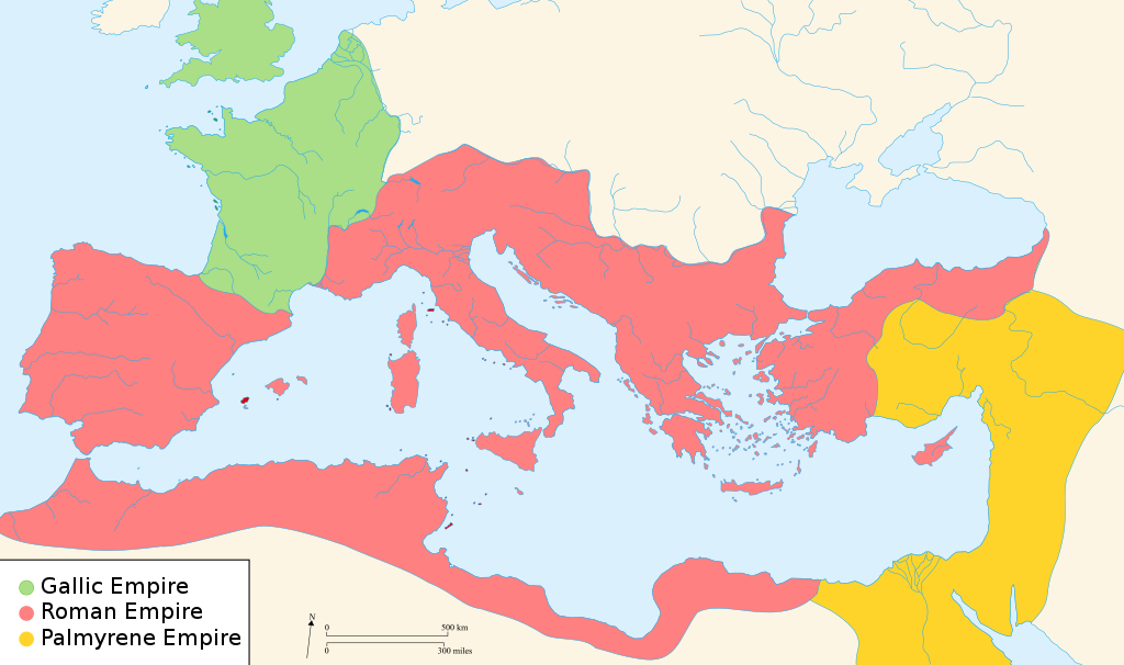
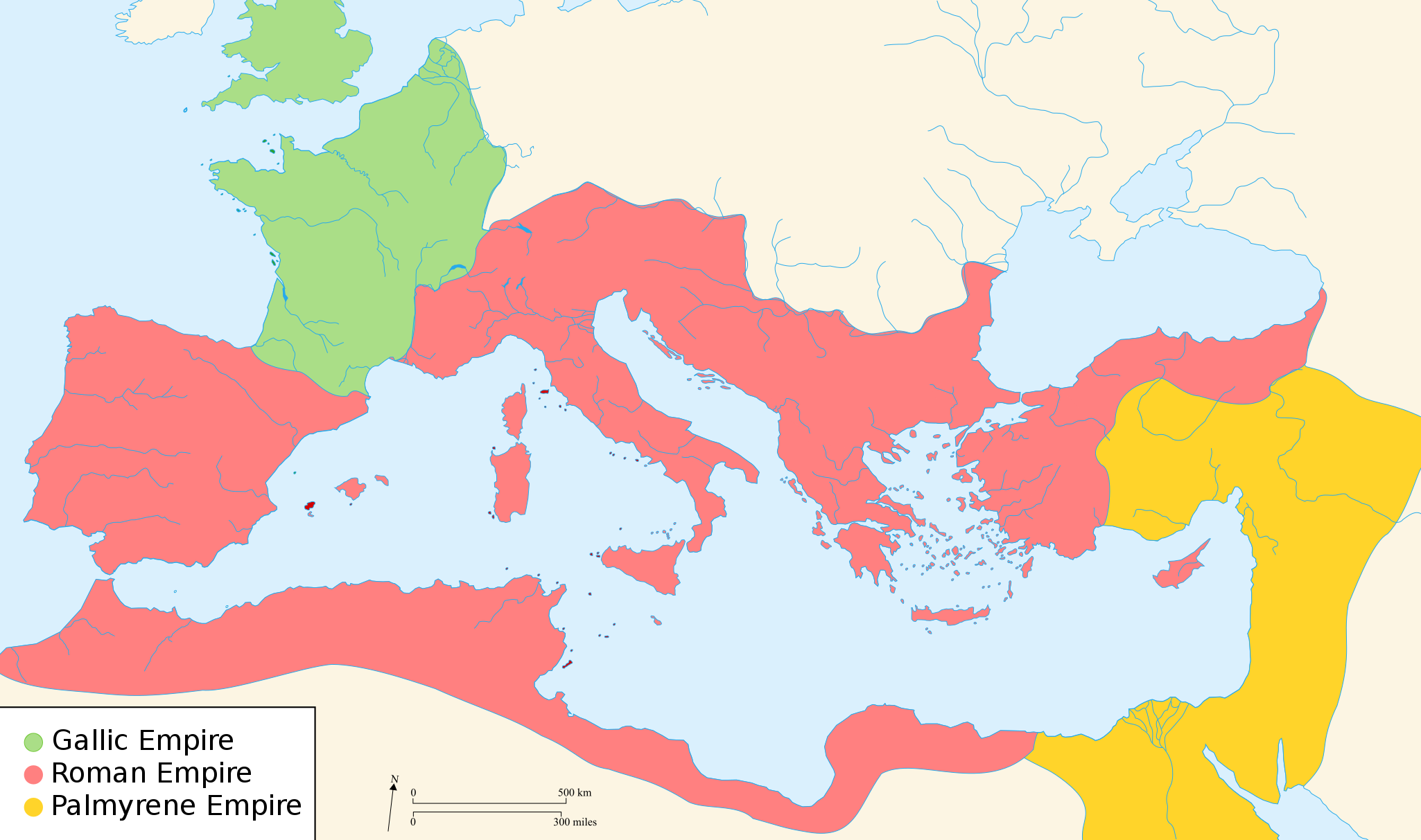
Territories of the Gallic Empire, the Roman Empire and the Palmyrene empire in the year 271.
概要[編集]
| 解説 |
English: Map of the Roman Empire around the year of the consulship of Aurelianus and Bassus (271 AD), with the break away Gallic Empire in the West and the Palmyrene Empire in the East. |
||
| 日付 | (UTC) | ||
| 原典 | |||
| 作者 |
|
||
| 許可 (ファイルの再利用) |
この作品の著作権者である私は、この作品を以下のライセンスで提供します。
あなたは上記のライセンスから、どれか一つ以上を選択できます。 |
||
| その他のバージョン |
[]
|


.svg)


|
このSVGファイルには翻訳可能な埋め込みテキストが含まれています。SVG翻訳ツールや他のSVGエディタを使用して自分の言語に翻訳可能です。詳しくはSVGファイルの翻訳についてを参照してください。 |
ライセンス[編集]

|
この文書は、フリーソフトウェア財団発行のGNUフリー文書利用許諾書 (GNU Free Documentation License) 1.2またはそれ以降のバージョンの規約に基づき、複製や再配布、改変が許可されます。不可変更部分、表紙、背表紙はありません。このライセンスの複製は、GNUフリー文書利用許諾書という章に含まれています。 著作権に示した解釈の下ライセンスされるものとします。 |
元のアップロードログ[編集]
元のファイルページはこちら。以下の利用者は全てen.wikipediaに属します。
- 2007-11-07 02:47 Justinian43 524×377×8 (26490 bytes) The Mediterranean by 271 A.D -The [[Roman Empire]]. -The breakaway [[Gallic Empire]]. -The breakaway [[Palmyrene Empire]].
- derivative work: Pomalee (talk)
other_versions=このファイルの派生的著作物: Map of Ancient Rome 271 AD-sr.svg Permission= GNU Free Documentation License, Version 1.2, Creative Commons Attribution-ShareAlike license versions 3.0, 2.5, 2.0, and 1.0
- Romanworld271AD.jpg: User:Justinian43, uploaded by User:El_bes
この画像には画像編集が施されています。原本に対して次のデジタル的な変更が行われました。
|

|
この文書は、フリーソフトウェア財団発行のGNUフリー文書利用許諾書 (GNU Free Documentation License) 1.2またはそれ以降のバージョンの規約に基づき、複製や再配布、改変が許可されます。不可変更部分、表紙、背表紙はありません。このライセンスの複製は、GNUフリー文書利用許諾書という章に含まれています。 |
| このファイルはクリエイティブ・コモンズ 表示-継承 3.0 非移植ライセンスのもとに利用を許諾されています。 | ||
| ||
| このライセンスのテンプレートは、GFDLのライセンス・アップデートによりこのファイルに追加されたものです。 |
元のアップロードログ[編集]
This image is a derivative work of the following images:
- File:Blank_map_of_South_Europe_and_North_Africa.svg licensed with Cc-by-sa-2.5,2.0,1.0, GFDL
- 2007-08-09T20:26:49Z Historicair 2050x1213 (1260388 Bytes)
- 2007-08-09T16:12:00Z Historicair 2050x1213 (351130 Bytes) {{Improving}} {{Information |Description={{fr}}Carte vierge de l'Europe du Sud et du Bassin Méditerranée dans l'Antiquité {{en}}Blank map of South Europe and North Africa at Antic period |Source=Own work + [[Image:Blank map of South Europe and North Africa.svg]] by myself
- File:Romanworld271AD.jpg licensed with GFDL-en
- 2007-11-20T15:23:56Z El bes 524x377 (26490 Bytes) {{Information |Description= The Roman Empire around the year 271 AD, with the break awai Gallic Empire in the West |Source= http://en.wikipedia.org/wiki/Image:Romanworld271AD.JPG |Date= November 20th, 2007 |Author= [[http://e
Uploaded with derivativeFX
ファイルの履歴
過去の版のファイルを表示するには、その版の日時をクリックしてください。
| 日付と時刻 | サムネイル | 寸法 | 利用者 | コメント | |
|---|---|---|---|---|---|
| 現在の版 | 2022年3月20日 (日) 21:07 | | 2,050 × 1,213 (207キロバイト) | Leptictidium (トーク | 投稿記録) | File uploaded using svgtranslate tool (https://svgtranslate.toolforge.org/). Added translation for ca. |
| 2018年8月24日 (金) 05:06 |  | 2,050 × 1,213 (207キロバイト) | Ras67 (トーク | 投稿記録) | frame removed | |
| 2011年12月18日 (日) 15:14 |  | 2,050 × 1,213 (385キロバイト) | Wanwa (トーク | 投稿記録) | more pleasant for eyesight colors | |
| 2010年8月27日 (金) 21:39 |  | 2,050 × 1,213 (384キロバイト) | Cplakidas (トーク | 投稿記録) | Corrections: the Agri Decumates beyond the Rhine had been abandoned already in 263, the Provence and Spain had been recovered by Rome in 269, and in 271, Zenobia controlled Asia Minor as far as Ancara at least | |
| 2009年2月26日 (木) 05:30 |  | 2,050 × 1,213 (396キロバイト) | Pomalee (トーク | 投稿記録) | Removed text labels from their paths and created a key. | |
| 2009年2月26日 (木) 04:36 |  | 2,050 × 1,213 (393キロバイト) | Pomalee (トーク | 投稿記録) | Changed the "Palmyran" label to "Palmyrene" | |
| 2009年2月26日 (木) 04:15 |  | 2,050 × 1,213 (393キロバイト) | Pomalee (トーク | 投稿記録) | {{Information |Description={{en}}Map of the Roman Empire around the year 271 AD, with the break away Gallic Empire in the West and the Palmyric Empire in the East. |Source=*File:Map_of_the_Ancient_Rome_at_Caesar_time-fr.svg *[[:File:Romanworld271AD. |
このファイルは上書きできません。
ファイルの使用状況
以下の 21 ページがこのファイルを使用しています:
- User:J budissin/Uploads/BiH/2018 August 21-31
- User:Magog the Ogre/Multilingual legend/2022 March 11-20
- File:Carte empire Romain 271.svg
- File:Imperium Romanum 271.jpg
- File:Map of Ancient Rome 260-269 AD-pt.svg
- File:Map of Ancient Rome 271 AD-ar.svg
- File:Map of Ancient Rome 271 AD-hu.svg
- File:Map of Ancient Rome 271 AD-id.svg
- File:Map of Ancient Rome 271 AD-pt.svg
- File:Map of Ancient Rome 271 AD-sr.svg
- File:Map of Ancient Rome 271 AD.svg
- File:Map of Ancient Rome 271 AD (hy).svg
- File:Map of Ancient Rome 271 AD ca.svg
- File:Map of Ancient Rome 271 AD fi.svg
- File:Map of Ancient Rome 271 AD hr.svg
- File:Map of Ancient Rome 271 AD la.svg
- File:Map of Ancient Rome 271 AD pl.svg
- File:Romanworld271AD-zh-classical.png
- File:Romanworld271AD.jpg
- Template:Other versions/Map of Ancient Rome 271 AD
- Category:Gallic Empire
グローバルなファイル使用状況
以下に挙げる他のウィキがこの画像を使っています:
- af.wikipedia.org での使用状況
- als.wikipedia.org での使用状況
- ar.wikipedia.org での使用状況
- azb.wikipedia.org での使用状況
- az.wikipedia.org での使用状況
- be-tarask.wikipedia.org での使用状況
- be.wikipedia.org での使用状況
- ca.wikipedia.org での使用状況
- cs.wikipedia.org での使用状況
- cy.wikipedia.org での使用状況
- de.wikipedia.org での使用状況
- el.wikipedia.org での使用状況
- en.wikipedia.org での使用状況
- 271
- Aurelian
- Claudius Gothicus
- Crisis of the Third Century
- Outline of ancient Rome
- Western Roman Empire
- Tetricus I
- Ancient Rome
- Late Latin
- Fall of the Western Roman Empire
- List of revolutions and rebellions
- Ledringhem
- List of Roman external wars and battles
- User:ChazCAESAR/sandbox
- User:Kazkaskazkasako/Books/History
- Classical Anatolia
このファイルのグローバル使用状況を表示する。