File:Map of Blackford County, Indiana.svg
Jump to navigation
Jump to search

Size of this PNG preview of this SVG file: 600 × 600 pixels. Other resolutions: 240 × 240 pixels | 480 × 480 pixels | 768 × 768 pixels | 1,024 × 1,024 pixels | 2,048 × 2,048 pixels.
Original file (SVG file, nominally 768 × 768 pixels, file size: 508 KB)
Captions
Captions
Add a one-line explanation of what this file represents
Summary
[edit]
| Description |
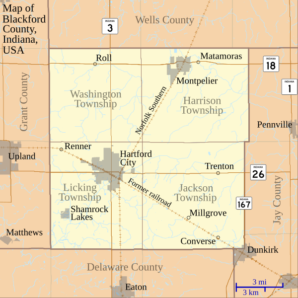
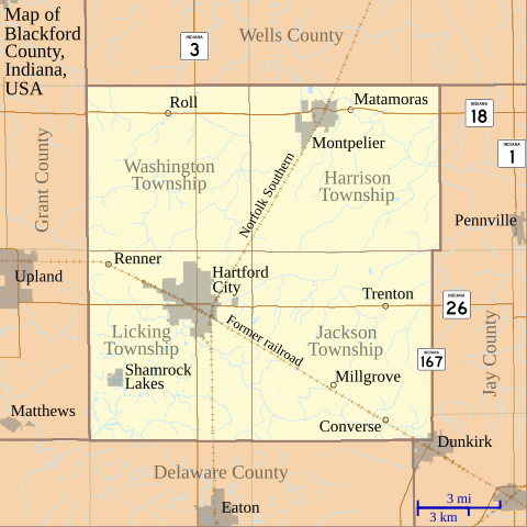
English: This is a map of Blackford County, Indiana, USA which shows settlements, county and township borders, and major transportation routes. |
| Date | |
| Source | My own work, using custom-written MapScript applications with freely-available United States Census Bureau TIGER data |
| Author | Omnedon |
Licensing
[edit]
| I, the copyright holder of this work, release this work into the public domain. This applies worldwide. In some countries this may not be legally possible; if so: I grant anyone the right to use this work for any purpose, without any conditions, unless such conditions are required by law. |
File history
Click on a date/time to view the file as it appeared at that time.
| Date/Time | Thumbnail | Dimensions | User | Comment | |
|---|---|---|---|---|---|
| current | 22:49, 2 July 2011 | | 768 × 768 (508 KB) | Omnedon (talk | contribs) | == {{int:filedesc}} == {{Information |Description={{en|This is a map of Blackford County, Indiana, USA which shows settlements, county and township borders, and major transportation routes.}} |Source=My own work, using cus |
| 04:14, 20 June 2011 |  | 768 × 768 (506 KB) | Omnedon (talk | contribs) | == {{int:filedesc}} == {{Information |Description={{en|This is a map of Blackford County, Indiana, USA which includes incorporated settlement and township borders.}} |Source=My own work, using custom-written [http://www.ma | |
| 23:28, 17 February 2008 |  | 768 × 768 (29 KB) | Omnedon (talk | contribs) | {{Information |Description={{en|This is a map of Blackford County, Indiana, USA which shows settlements, townships, roads, railroads, and major rivers.}} |Source=My own work, using freely-available shape data and custom-written MapScript applications |Dat |
You cannot overwrite this file.
File usage on Commons
The following page uses this file:
File usage on other wikis
The following other wikis use this file:
- Usage on ar.wikipedia.org
- Usage on ceb.wikipedia.org
- Usage on en.wikipedia.org
- Blackford County, Indiana
- Converse, Blackford County, Indiana
- Matamoras, Indiana
- Millgrove, Indiana
- Renner, Indiana
- Roll, Indiana
- Trenton, Indiana
- History of Hartford City, Indiana
- First Presbyterian Church (Hartford City, Indiana)
- Hartford City Courthouse Square Historic District
- Blackford County Courthouse
- Module:Location map/data/USA Indiana Blackford County/doc
- Montpelier Carnegie Library
- Module:Location map/data/USA Indiana Blackford County
- Usage on es.wikipedia.org
- Usage on fa.wikipedia.org
- Usage on fr.wikipedia.org
- Usage on kn.wikipedia.org
- Usage on nl.wikipedia.org
- Usage on ro.wikipedia.org
- Usage on si.wikipedia.org
- Usage on tr.wikipedia.org
- Usage on war.wikipedia.org