File:Map of California highlighting Monterey County.svg
Jump to navigation
Jump to search

Size of this PNG preview of this SVG file: 523 × 599 pixels. Other resolutions: 209 × 240 pixels | 419 × 480 pixels | 670 × 768 pixels | 894 × 1,024 pixels | 1,787 × 2,048 pixels | 1,022 × 1,171 pixels.
Original file (SVG file, nominally 1,022 × 1,171 pixels, file size: 501 KB)
Captions
Captions
Add a one-line explanation of what this file represents
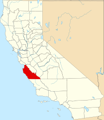
- English: A locator map showing Monterey County in California.
David Benbennick made this map. For more information, see Commons:United States county locator maps.
| I, the copyright holder of this work, release this work into the public domain. This applies worldwide. In some countries this may not be legally possible; if so: I grant anyone the right to use this work for any purpose, without any conditions, unless such conditions are required by law. |
File history
Click on a date/time to view the file as it appeared at that time.
| Date/Time | Thumbnail | Dimensions | User | Comment | |
|---|---|---|---|---|---|
| current | 18:41, 25 November 2016 | | 1,022 × 1,171 (501 KB) | Spartan7W (talk | contribs) | Update HQ map |
| 10:26, 12 February 2006 |  | 9,164 × 10,536 (229 KB) | David Benbennick (talk | contribs) | {{subst:User:Dbenbenn/clm|county=Monterey County|state=California}} |
You cannot overwrite this file.
File usage
The following 12 pages use this file:
- Category:2021 in Monterey County, California
- Category:Births in Monterey County, California
- Category:Bridges in Monterey County, California
- Category:Deaths in Monterey County, California
- Category:Geography of Monterey County, California
- Category:History of Monterey County, California
- Category:Maps of Monterey County, California
- Category:Monterey County, California
- Category:Nature of Monterey County, California
- Category:People of Monterey County, California
- Category:Roads in Monterey County, California
- Category:Transport in Monterey County, California
Global file usage
The following other wikis use this file:
- Usage on af.wikipedia.org
- Usage on ar.wikipedia.org
- مقاطعة مونتيري (كاليفورنيا)
- ساليناس (كاليفورنيا)
- كارميل-بي-ثي-سي (كاليفورنيا)
- ديل ري أوكس
- غونزاليس (كاليفورنيا)
- غرينفيلد (كاليفورنيا)
- كينغ سيتي (كاليفورنيا)
- مارينا (كاليفورنيا)
- مونتيري (كاليفورنيا)
- باسيفيك غروف
- ساند سيتي (كاليفورنيا)
- سيسيدي (كاليفورنيا)
- سوليداد (كاليفورنيا)
- ديل مونتي فورست (كاليفورنيا)
- كارمل فالي (كاليفورنيا)
- إلكورن (كاليفورنيا)
- سان لوكاس (كاليفورنيا)
- قالب:مقاطعة مونتيري (كاليفورنيا)
- باجارو (كاليفورنيا)
- أروماس (كاليفورنيا)
- بوروندا (كاليفورنيا)
- سبريكيلس (كاليفورنيا)
- لاس لوماس (كاليفورنيا)
- Usage on az.wikipedia.org
- Usage on ban.wikipedia.org
- Usage on be.wikipedia.org
- Usage on bpy.wikipedia.org
- Usage on ca.wikipedia.org
- Sacramento
- Monterey
- Arden-Arcade
- Aromas (Califòrnia)
- Boronda
- Bradley (Califòrnia)
- Carmel Valley Village
- Carmel-by-the-Sea
- Carmichael
- Castroville (Califòrnia)
- Chualar
- Citrus Heights
- Del Monte Forest
- Del Rey Oaks
- Elk Grove
- Elkhorn (Califòrnia)
- Fair Oaks (Califòrnia)
- Florin (Califòrnia)
- Folsom (Califòrnia)
- Foothill Farms
- Gold River
View more global usage of this file.