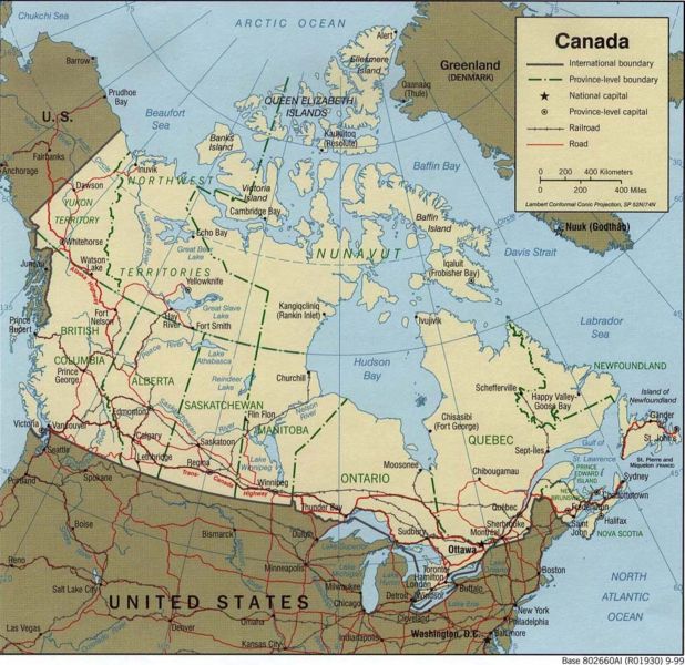
File:Map of Canada.jpg
Siirry navigaatioon
Siirry hakuun

Tämän esikatselun koko: 618 × 600 kuvapistettä. Muut resoluutiot: 247 × 240 kuvapistettä | 495 × 480 kuvapistettä | 977 × 948 kuvapistettä.
Alkuperäinen tiedosto (977 × 948 kuvapistettä, 244 KiB, MIME-tyyppi: image/jpeg)
Kuvatekstit
Kuvatekstit
Lisää yhden rivin pituinen kuvaus tästä tiedostosta
Source: Perry-Castañeda Library Map Collection (a collection of maps where most are in public domain, see Library Web Material Usage Statement.
"Courtesy of the University of Texas Libraries, The University of Texas at Austin."
This file is in the public domain because it's material from the Perry-Castañeda Library
Map Collection, collection of maps where most are in public domain)
|
Tiedoston historia
Päiväystä napsauttamalla näet, millainen tiedosto oli kyseisellä hetkellä.
| Päiväys | Pienoiskuva | Koko | Käyttäjä | Kommentti | |
|---|---|---|---|---|---|
| nykyinen | 27. heinäkuuta 2006 kello 08.58 | | 977 × 948 (244 KiB) | Frumpy (keskustelu | muokkaukset) | cropped |
| 2. maaliskuuta 2006 kello 05.29 |  | 1 050 × 1 030 (272 KiB) | Leslie (keskustelu | muokkaukset) | Source: [http://www.lib.utexas.edu/maps/united_states Perry-Castañeda Library Map Collection] (a collection of maps where most are in public domain, see [http://www.lib.utexas.edu/usage_statement.html?maps=yes Library Web Material Usage Statement]. ''"C |
Et voi tallentaa uutta tiedostoa tämän tilalle.
Tiedoston käyttö
Tätä tiedostoa ei käytetä millään sivulla.
Tiedoston järjestelmänlaajuinen käyttö
Seuraavat muut wikit käyttävät tätä tiedostoa:
- Käyttö kohteessa en.wikipedia.org
- Käyttö kohteessa fa.wikipedia.org
- Käyttö kohteessa fi.wikipedia.org
- Käyttö kohteessa fr.wikipedia.org
- Käyttö kohteessa gom.wikipedia.org
- Käyttö kohteessa pt.wikipedia.org
- Käyttö kohteessa uk.wikipedia.org