File:Map of Case Black.JPG
Alkuperäinen tiedosto (1 715 × 1 920 kuvapistettä, 1,19 MiB, MIME-tyyppi: image/jpeg)
Kuvatekstit
Kuvatekstit
Yhteenveto[muokkaa]
| Kuvaus |
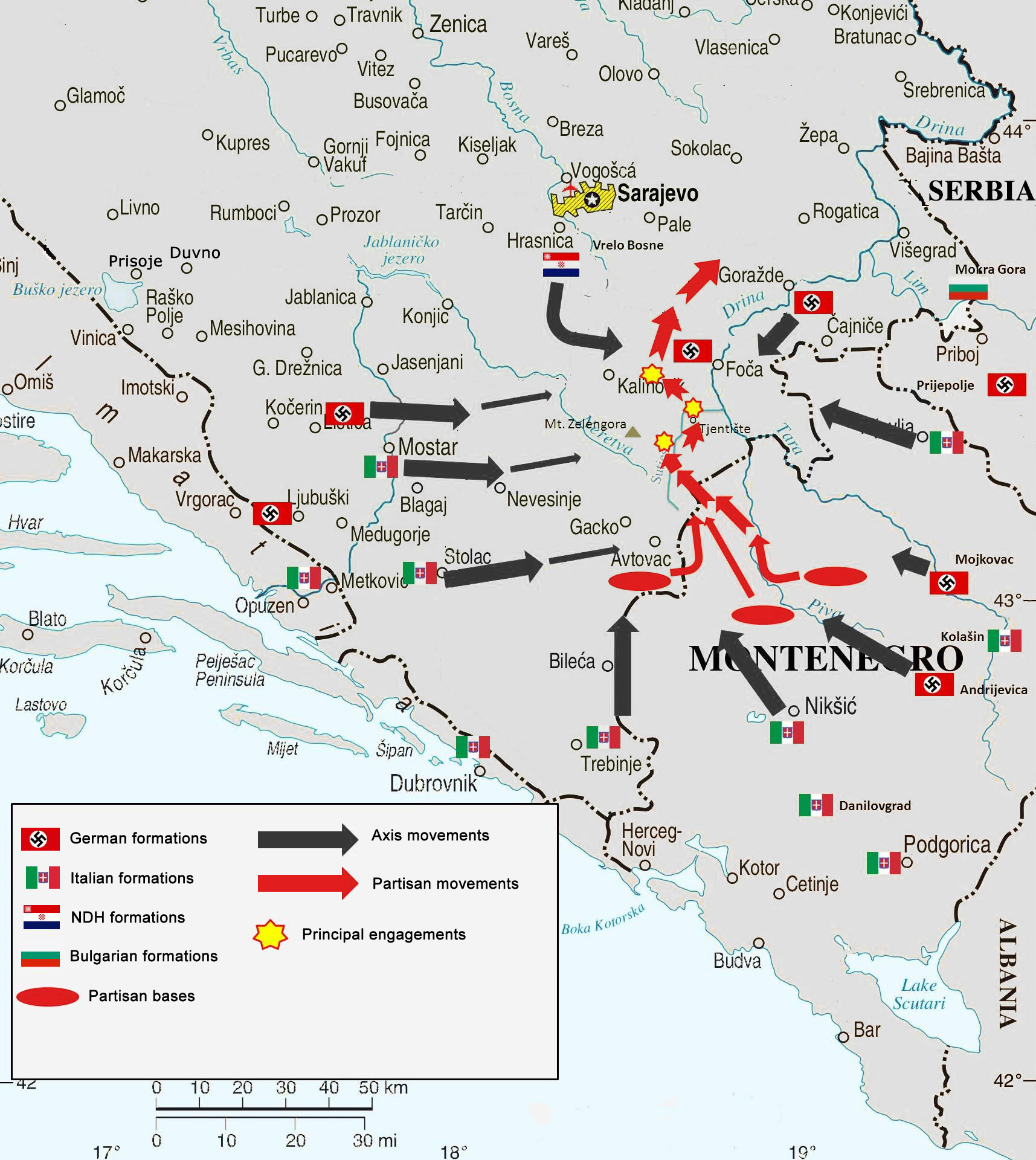
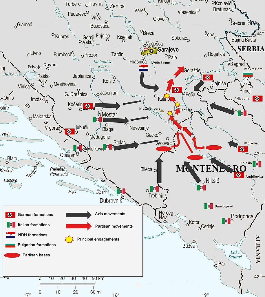
English: Map of Case Black, superimposed on modern-day country borders (entity borders did not exist in 1943). |
|||
| Päiväys | ||||
| Lähde | Own work, based on File:Bosnia and Hercegovina map.png and this source of information. | |||
| Tekijä | Cartographer of the United Nations | |||
| Käyttöoikeus (Tämän tiedoston uudelleenkäyttö) |
|
|||
| Muut versiot |
|


Lisenssi[muokkaa]
- Voit:
- jakaa – kopioida, levittää ja esittää teosta
- remiksata – valmistaa muutettuja teoksia
- Seuraavilla ehdoilla:
- nimeäminen – Sinun on mainittava lähde asianmukaisesti, tarjottava linkki lisenssiin sekä merkittävä, mikäli olet tehnyt muutoksia. Voit tehdä yllä olevan millä tahansa kohtuullisella tavalla, mutta et siten, että annat ymmärtää lisenssinantajan suosittelevan sinua tai teoksen käyttöäsi.
Tiedoston historia
Päiväystä napsauttamalla näet, millainen tiedosto oli kyseisellä hetkellä.
| Päiväys | Pienoiskuva | Koko | Käyttäjä | Kommentti | |
|---|---|---|---|---|---|
| nykyinen | 9. heinäkuuta 2017 kello 01.45 | | 1 715 × 1 920 (1,19 MiB) | BiHVolim (keskustelu | muokkaukset) | Entity borders of Bosniak-Croat Federation an Republika Srpska entity did not exist in 1943. They are a product of signing of Dayton Agreements in 1995; therefore can not be part of this map. also moved Serbia caption to not cross into Bosnia-Herzegovi... |
| 6. syyskuuta 2014 kello 07.47 |  | 1 715 × 1 920 (1,25 MiB) | DIREKTOR (keskustelu | muokkaukset) | Small fix. | |
| 12. joulukuuta 2012 kello 18.36 |  | 1 715 × 1 920 (1,25 MiB) | DIREKTOR (keskustelu | muokkaukset) | Further | |
| 12. joulukuuta 2012 kello 18.34 |  | 1 715 × 1 920 (1,26 MiB) | DIREKTOR (keskustelu | muokkaukset) | Further | |
| 12. joulukuuta 2012 kello 18.32 |  | 1 715 × 1 920 (1,25 MiB) | DIREKTOR (keskustelu | muokkaukset) | Fix | |
| 12. joulukuuta 2012 kello 18.21 |  | 1 715 × 1 920 (1,26 MiB) | DIREKTOR (keskustelu | muokkaukset) | User created page with UploadWizard |
Et voi tallentaa uutta tiedostoa tämän tilalle.
Tiedoston käyttö
Seuraavat 4 sivua käyttävät tätä tiedostoa:
Tiedoston järjestelmänlaajuinen käyttö
Seuraavat muut wikit käyttävät tätä tiedostoa:
- Käyttö kohteessa bs.wikipedia.org
- Käyttö kohteessa de.wikipedia.org
- Käyttö kohteessa en.wikipedia.org
- Käyttö kohteessa fi.wikipedia.org
- Käyttö kohteessa fr.wikipedia.org
- Käyttö kohteessa hr.wikipedia.org
- Käyttö kohteessa it.wikipedia.org
- Käyttö kohteessa mk.wikipedia.org
- Käyttö kohteessa nl.wikipedia.org
- Käyttö kohteessa pt.wikipedia.org
- Käyttö kohteessa sl.wikipedia.org
- Käyttö kohteessa www.wikidata.org