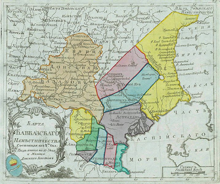
File:Map of Caucasus Namestnichestvo 1792 (small atlas).jpg
Wikimedia Commons saytından
Naviqasiyaya keç
Axtarışa keç

Sınaq göstərişi ölçüsü: 717 × 600 piksel. Digər ölçülər: 287 × 240 piksel | 574 × 480 piksel | 918 × 768 piksel | 1.224 × 1.024 piksel | 2.448 × 2.048 piksel | 2.643 × 2.211 piksel.
Faylın orijinalı (2.643 × 2.211 piksel, fayl həcmi: 932 KB, MIME növü: image/jpeg)
File information
Structured data
Captions
Captions
Add a one-line explanation of what this file represents
Xülasə[redaktə]
| İzahMap of Caucasus Namestnichestvo 1792 (small atlas).jpg |
Русский: Малоформатный атлас Российской империи (1792). Карта 1-го Кавказского наместничества и земель Донских казаков(карта 42).
English: Small atlas of the Russian Empire (1792). Map of 1st Caucasus Viceroyalty (Namestnichestvo) and Don Voisko (map 42). |
|||
| Tarix | ||||
| Mənbə |
Русский: Атлас Российской империи, : Состоящий из 46 карт, : Изданный во граде св. Петра 1792 года / отпечатан не ранее 1793 года. Цифровая копия сделана Российской государственной библиотекой (http://www.rsl.ru)
English: Atlas of the Russian Empire (1792), : Consist of 46 maps, : Published in St. Petersburg (1792) / printed in 1793 or later. Digital copy made by Russian State Library (http://www.rsl.ru/en) |
|||
| Müəllif |
Русский: издатель: типография Сытина
English: publisher:Sytin's print shop |
|||
| Digər versiyalar |
|
Lisenziya[redaktə]
| Public domainPublic domainfalsefalse |
|
This work is in the public domain in its country of origin and other countries and areas where the copyright term is the author's life plus 100 years or fewer. | |
| This file has been identified as being free of known restrictions under copyright law, including all related and neighboring rights. | |
https://creativecommons.org/publicdomain/mark/1.0/PDMCreative Commons Public Domain Mark 1.0falsefalse
Faylın tarixçəsi
Faylın əvvəlki versiyasını görmək üçün gün/tarix bölməsindəki tarixlərə klikləyin.
| Tarix/Vaxt | Kiçik şəkil | Ölçülər | İstifadəçi | Şərh | |
|---|---|---|---|---|---|
| indiki | 20:31, 12 dekabr 2009 |  | 2.643 × 2.211 (932 KB) | Transcend (rus) (müzakirə | töhfələr) | == {{int:filedesc}} == {{Information |Description= {{ru|Малоформатный атлас Российской империи (1792). Карта 1-го Кавказского наместничества (лист 43).}} {{en|Small atlas of the Russia |
Siz bu faylı yenidən yükləyə bilməzsiniz.
Fayl keçidləri
Aşağıdakı 2 səhifə bu faylı istifadə edir:
Faylın qlobal istifadəsi
Bu fayl aşağıdakı vikilərdə istifadə olunur:
- azb.wikipedia.org layihəsində istifadəsi
- az.wikipedia.org layihəsində istifadəsi
- bg.wikipedia.org layihəsində istifadəsi
- ce.wikipedia.org layihəsində istifadəsi
- en.wikipedia.org layihəsində istifadəsi
- es.wikipedia.org layihəsində istifadəsi
- et.wikipedia.org layihəsində istifadəsi
- fi.wikipedia.org layihəsində istifadəsi
- ka.wikipedia.org layihəsində istifadəsi
- ru.wikipedia.org layihəsində istifadəsi
- uk.wikipedia.org layihəsində istifadəsi
- www.wikidata.org layihəsində istifadəsi
Metaməlumatlar
Bu faylda fotoaparat və ya skanerlə əlavə olunmuş məlumatlar var. Əgər fayl sonradan redaktə olunubsa, bəzi parametrlər bu şəkildə göstərilənlərdən fərqli ola bilər.
| _error | 0 |
|---|

