File:Map of Hertenrits sites.svg
Jump to navigation
Jump to search

Size of this PNG preview of this SVG file: 563 × 324 pixels. Other resolutions: 320 × 184 pixels | 640 × 368 pixels | 1,024 × 589 pixels | 1,280 × 737 pixels | 2,560 × 1,473 pixels.
Original file (SVG file, nominally 563 × 324 pixels, file size: 48 KB)
Captions
Captions
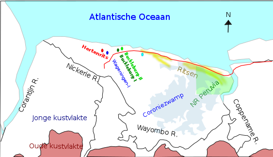
Maps of the archeological mounds in the Hertenrits area of Suriname,
Summary
[edit]
| Description |
English: Map after Barrancoid and Arauquinoid Mound Builders in Coastal Suriname; Aad H. Versteeg, in:Handbook of South American Archaeology 2008; ISBN 9780387752280, ISBN 0387752285 |
| Date | |
| Source | Own work |
| Author | Jcwf |
Licensing
[edit]
I, the copyright holder of this work, hereby publish it under the following license:
This file is licensed under the Creative Commons Attribution-Share Alike 4.0 International license.
- You are free:
- to share – to copy, distribute and transmit the work
- to remix – to adapt the work
- Under the following conditions:
- attribution – You must give appropriate credit, provide a link to the license, and indicate if changes were made. You may do so in any reasonable manner, but not in any way that suggests the licensor endorses you or your use.
- share alike – If you remix, transform, or build upon the material, you must distribute your contributions under the same or compatible license as the original.
File history
Click on a date/time to view the file as it appeared at that time.
| Date/Time | Thumbnail | Dimensions | User | Comment | |
|---|---|---|---|---|---|
| current | 03:55, 1 August 2020 | | 563 × 324 (48 KB) | Jcwf (talk | contribs) | added the Coronie swam[] |
| 01:40, 1 August 2020 |  | 563 × 324 (43 KB) | Jcwf (talk | contribs) | Added main east west road in red and Peruvia Nature reserve in green | |
| 04:30, 19 July 2020 |  | 563 × 324 (42 KB) | Jcwf (talk | contribs) | Uploaded own work with UploadWizard |
You cannot overwrite this file.
File usage on Commons
There are no pages that use this file.
File usage on other wikis
The following other wikis use this file:
- Usage on de.wikipedia.org
- Usage on en.wikipedia.org
- Usage on nl.wikipedia.org