File:Map of Iceland highlands-en.svg
Jump to navigation
Jump to search

Size of this PNG preview of this SVG file: 739 × 600 pixels. Other resolutions: 296 × 240 pixels | 591 × 480 pixels | 946 × 768 pixels | 1,261 × 1,024 pixels | 2,523 × 2,048 pixels | 1,834 × 1,489 pixels.
Original file (SVG file, nominally 1,834 × 1,489 pixels, file size: 505 KB)
Captions
Captions
Add a one-line explanation of what this file represents
| Description |
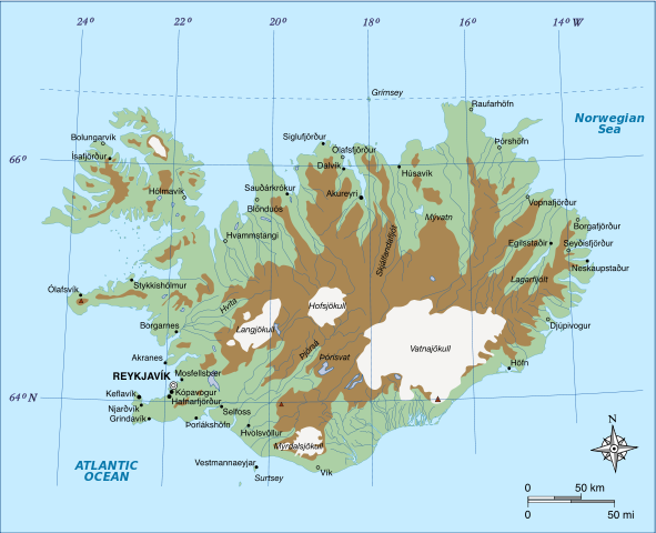
English: Highlands of Iceland map. Height < 500 meters approx. Height > 500 meters approx. (Iceland Highlands) Glaciers Français : Carte des Hautes Terres d'Islande Altitude inférieure à 500 mètres environ Altitude supérieure à 500 mètres environ (Hautes Terres d'Islande) Glaciers |
| Date | (UTC) |
| Source | |
| Author |
|
I, the copyright holder of this work, hereby publish it under the following licenses:
This file is licensed under the Creative Commons Attribution-Share Alike 3.0 Unported, 2.5 Generic, 2.0 Generic and 1.0 Generic license.
- You are free:
- to share – to copy, distribute and transmit the work
- to remix – to adapt the work
- Under the following conditions:
- attribution – You must give appropriate credit, provide a link to the license, and indicate if changes were made. You may do so in any reasonable manner, but not in any way that suggests the licensor endorses you or your use.
- share alike – If you remix, transform, or build upon the material, you must distribute your contributions under the same or compatible license as the original.

|
Permission is granted to copy, distribute and/or modify this document under the terms of the GNU Free Documentation License, Version 1.2 or any later version published by the Free Software Foundation; with no Invariant Sections, no Front-Cover Texts, and no Back-Cover Texts. A copy of the license is included in the section entitled GNU Free Documentation License. |
You may select the license of your choice.
Original upload log[edit]
This image is a derivative work of the following images:
- File:Map_of_Iceland_highlands.svg licensed with Cc-by-sa-3.0,2.5,2.0,1.0, GFDL
- 2010-03-22T11:33:25Z Pethrus 1834x1489 (517540 Bytes) {{Information |Description={{en|Map of Iceland highlands}}{{fr|1=Carte des Hautes Terres d'Islande}} |Source=*[[:File:Map_of_Iceland_el.svg|]] |Date=2010-03-22 11:32 (UTC) |Author=*[[:File:Map_of_Iceland_el.svg|]]: [[:el:Χρ
Uploaded with derivativeFX
File history
Click on a date/time to view the file as it appeared at that time.
| Date/Time | Thumbnail | Dimensions | User | Comment | |
|---|---|---|---|---|---|
| current | 12:02, 25 March 2010 | | 1,834 × 1,489 (505 KB) | Pethrus (talk | contribs) | {{Information |Description={{en|Highlands of Iceland map. {{legend|#acd0a5|Height < 500 meters approx.}} {{legend|#aa8753|Height > 500 meters approx. (Iceland Highlands)}} {{legend|#f5f4f2|Glaciers}} }} {{fr|1=Carte des Hautes Terres d'Islande {{legend|#a |
You cannot overwrite this file.
File usage on Commons
The following page uses this file:
File usage on other wikis
The following other wikis use this file:
- Usage on ar.wikipedia.org
- Usage on ast.wikipedia.org
- Usage on ban.wikipedia.org
- Usage on da.wikipedia.org
- Usage on de.wikipedia.org
- Usage on el.wikipedia.org
- Usage on en.wikipedia.org
- Usage on es.wikipedia.org
- Usage on fa.wikipedia.org
- Usage on hu.wikipedia.org
- Usage on id.wikipedia.org
- Usage on is.wikipedia.org
- Usage on it.wikipedia.org
- Usage on ja.wikipedia.org
- Usage on ka.wikipedia.org
- Usage on ko.wikipedia.org
- Usage on mk.wikipedia.org
- Usage on mt.wikipedia.org
- Usage on pl.wikipedia.org
- Usage on pt.wikipedia.org
- Usage on ru.wikipedia.org
- Usage on sv.wikipedia.org
- Usage on tr.wikipedia.org
- Usage on uk.wikipedia.org
- Usage on zh.wikipedia.org