File:Map of Illinois highlighting Union County.svg
Jump to navigation
Jump to search

Size of this PNG preview of this SVG file: 336 × 599 pixels. Other resolutions: 134 × 240 pixels | 269 × 480 pixels | 430 × 768 pixels | 574 × 1,024 pixels | 1,148 × 2,048 pixels | 3,453 × 6,157 pixels.
Original file (SVG file, nominally 3,453 × 6,157 pixels, file size: 85 KB)
Captions
Captions
Add a one-line explanation of what this file represents
Summary[edit]
| Description |
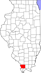
English: This is a locator map showing Union County in Illinois. For more information, see Commons:United States county locator maps. |
| Date | |
| Source |
Own work: English: The maps use data from nationalatlas.gov, specifically countyp020.tar.gz on the Raw Data Download page. The maps also use state outline data from statesp020.tar.gz. The Florida maps use hydrogm020.tar.gz to display Lake Okeechobee. |
| Author | David Benbennick |
Licensing[edit]
| I, the copyright holder of this work, release this work into the public domain. This applies worldwide. In some countries this may not be legally possible; if so: I grant anyone the right to use this work for any purpose, without any conditions, unless such conditions are required by law. |
File history
Click on a date/time to view the file as it appeared at that time.
| Date/Time | Thumbnail | Dimensions | User | Comment | |
|---|---|---|---|---|---|
| current | 11:36, 12 February 2006 | | 3,453 × 6,157 (85 KB) | David Benbennick (talk | contribs) | {{subst:User:Dbenbenn/clm|county=Union County|state=Illinois}} |
You cannot overwrite this file.
File usage
The following 9 pages use this file:
- Category:Births in Union County, Illinois
- Category:Deaths in Union County, Illinois
- Category:Geography of Union County, Illinois
- Category:Maps of Union County, Illinois
- Category:National Register of Historic Places in Union County, Illinois
- Category:People of Union County, Illinois
- Category:Populated places in Union County, Illinois
- Category:Union County, Illinois
- Category:Villages in Union County, Illinois
Global file usage
The following other wikis use this file:
- Usage on ar.wikipedia.org
- Usage on bg.wikipedia.org
- Usage on bpy.wikipedia.org
- Usage on ca.wikipedia.org
- Usage on cdo.wikipedia.org
- Usage on ceb.wikipedia.org
- Usage on ce.wikipedia.org
- Usage on cs.wikipedia.org
- Usage on cy.wikipedia.org
- Usage on de.wikipedia.org
- Usage on en.wikipedia.org
- List of counties in Illinois
- Union County, Illinois
- Alto Pass, Illinois
- Anna, Illinois
- Cobden, Illinois
- Dongola, Illinois
- Jonesboro, Illinois
- Mill Creek, Illinois
- Template:Union County, Illinois
- Giant City State Park
- Template:UnionCountyIL-geo-stub
- Trail of Tears State Forest
- Union County State Fish and Wildlife Area
- Reynoldsville, Illinois
- Ware, Illinois
- Category:Wikipedia requested photographs in Union County, Illinois
- Wolf Lake, Illinois
- User:Nyttend/County templates/IL/3
- Balcom, Illinois
- Category:Populated places in Union County, Illinois
- National Register of Historic Places listings in Union County, Illinois
- Ware Mounds and Village Site
- La Rue, Illinois
- Anna State Hospital
- Usage on eo.wikipedia.org
- Usage on es.wikipedia.org
- Usage on et.wikipedia.org
- Usage on eu.wikipedia.org
View more global usage of this file.