File:Map of Japan with highlight on 43 Kumamoto prefecture.svg
跳至導覽
跳至搜尋

此 SVG 檔案的 PNG 預覽的大小:600 × 600 像素。 其他解析度:240 × 240 像素 | 480 × 480 像素 | 768 × 768 像素 | 1,024 × 1,024 像素 | 2,048 × 2,048 像素。
原始檔案 (SVG 檔案,表面大小:1,024 × 1,024 像素,檔案大小:15 KB)
說明
說明
添加單行說明來描述出檔案所代表的內容
| 描述 |
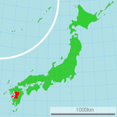
日本語: 熊本県の位置図
English: Map of Japan with highlight on Kumamoto-ken |
||||||||
| 來源 | 国土交通省 国土数値情報(行政区域) | ||||||||
| 作者 | Lincun | ||||||||
| 授權許可 (重用此檔案) |
|

原始上傳日誌
[編輯]
| date/time | username | resolution | size | edit summary |
|---|---|---|---|---|
| 16:47, 2 March 2007 | User:Lincun | 1,024×1,024 | 15 KB | <span class="comment">({{都道府県地図情報 |都道府県=熊本県 |都道府県Latin=Kumamoto-ken }} )</span> |
檔案歷史
點選日期/時間以檢視該時間的檔案版本。
| 日期/時間 | 縮圖 | 尺寸 | 使用者 | 備註 | |
|---|---|---|---|---|---|
| 目前 | 2011年3月16日 (三) 00:54 | | 1,024 × 1,024(15 KB) | TAKASUGI Shinji(留言 | 貢獻) | color changes for a better contrast: lightgreen → limegreen deeppink → red |
| 2008年4月21日 (一) 02:22 |  | 1,024 × 1,024(15 KB) | BetacommandBot(留言 | 貢獻) | move approved by: User:LERK This image was moved from Image:Map of Japan with highlight on 43 Kumamoto 熊本県.svg {{User:Lincun/都道府県地図情報 |都道府県=熊本県 |都道府県Latin=Kumamoto-ken }} [[Category:Maps of Kumamoto |
無法覆蓋此檔案。
檔案用途
超過 100 個頁面有用到此檔案。 下列清單只列出前 100 筆有用到此檔案的頁面。 您也可以檢視完整清單。
- Atlas of Japan
- Kumamoto prefecture
- Maps of Japan
- Category:1999 in Kumamoto prefecture
- Category:2000 in Kumamoto prefecture
- Category:2004 in Kumamoto prefecture
- Category:2005 in Kumamoto prefecture
- Category:2007 in Kumamoto prefecture
- Category:2008 in Kumamoto prefecture
- Category:2009 in Kumamoto prefecture
- Category:2010 in Kumamoto prefecture
- Category:2011 in Kumamoto prefecture
- Category:2012 in Kumamoto prefecture
- Category:2013 in Kumamoto prefecture
- Category:2014 in Kumamoto prefecture
- Category:2015 in Kumamoto prefecture
- Category:2016 in Kumamoto prefecture
- Category:2017 in Kumamoto prefecture
- Category:2018 in Kumamoto prefecture
- Category:Aerial photographs of Kumamoto prefecture
- Category:Agriculture of Kumamoto prefecture
- Category:Animals of Kumamoto prefecture
- Category:Antenna towers and masts in Kumamoto prefecture
- Category:April 2018 in Kumamoto prefecture
- Category:Autumn in Kumamoto prefecture
- Category:Bank buildings in Kumamoto prefecture
- Category:Baseball players from Kumamoto prefecture
- Category:Beaches of Kumamoto prefecture
- Category:Births in Kumamoto prefecture
- Category:Bodies of water in Kumamoto prefecture
- Category:Bus operators in Kumamoto prefecture
- Category:Bus stops in Kumamoto prefecture
- Category:Bus transport in Kumamoto prefecture
- Category:Churches in Kumamoto prefecture
- Category:Community centres in Kumamoto prefecture
- Category:Concert halls in Kumamoto prefecture
- Category:Corporate headquarters in Kumamoto prefecture
- Category:Deaths in Kumamoto prefecture
- Category:Demographics of Kumamoto prefecture
- Category:Department stores in Kumamoto prefecture
- Category:Economy of Kumamoto prefecture
- Category:Elections in Kumamoto prefecture
- Category:Entertainment venues in Kumamoto prefecture
- Category:February in Kumamoto prefecture
- Category:Fisheries of Kumamoto prefecture
- Category:Flowers in Kumamoto prefecture
- Category:Geography of Kumamoto prefecture
- Category:Governors of Kumamoto prefecture
- Category:Graves in Kumamoto prefecture
- Category:History of Kumamoto prefecture
- Category:Interchanges in Kumamoto prefecture
- Category:Intersections in Kumamoto prefecture
- Category:January in Kumamoto prefecture
- Category:June 2018 in Kumamoto prefecture
- Category:Kumamoto prefecture
- Category:Kumamoto prefecture by year
- Category:Landforms of Kumamoto prefecture
- Category:Locator maps of Kumamoto prefecture
- Category:Locator maps of municipalities in Kumamoto prefecture
- Category:Maps of Kumamoto prefecture
- Category:Monuments and memorials in Kumamoto prefecture
- Category:National government buildings in Kumamoto prefecture
- Category:Natural disasters in Kumamoto prefecture
- Category:Nature of Kumamoto prefecture
- Category:Office buildings in Kumamoto prefecture
- Category:People of Kumamoto prefecture
- Category:Population distribution of municipalities of Kumamoto prefecture
- Category:Power plants in Kumamoto prefecture
- Category:Preserved steam locomotives in Kumamoto prefecture
- Category:Radio stations in Kumamoto prefecture
- Category:Rail transport in Kumamoto prefecture
- Category:Railway bridges in Kumamoto prefecture
- Category:Railway lines in Kumamoto prefecture
- Category:Religious buildings in Kumamoto prefecture
- Category:Road transport in Kumamoto prefecture
- Category:Roads in Kumamoto prefecture
- Category:Sake breweries in Kumamoto prefecture
- Category:Sakura in Kumamoto prefecture
- Category:Seasons in Kumamoto prefecture
- Category:Shopping arcades in Kumamoto prefecture
- Category:Shopping streets in Kumamoto prefecture
- Category:Signs in Kumamoto prefecture
- Category:Skylines in Kumamoto prefecture
- Category:Sportspeople from Kumamoto prefecture
- Category:Spring in Kumamoto prefecture
- Category:Structures in Kumamoto prefecture
- Category:Summer in Kumamoto prefecture
- Category:Sunsets of Kumamoto prefecture
- Category:Supermarkets in Kumamoto prefecture
- Category:Symbols of municipalities in Kumamoto prefecture
- Category:Television stations in Kumamoto prefecture
- Category:Theaters in Kumamoto prefecture
- Category:Topographic maps of Kumamoto prefecture
- Category:Town halls in Kumamoto prefecture
- Category:Train station signs in Kumamoto prefecture
- Category:Transport buildings in Kumamoto prefecture
- Category:Transport in Kumamoto prefecture
- Category:Transport infrastructure in Kumamoto prefecture
- Category:Trees in Kumamoto prefecture
- Category:Tunnels in Kumamoto prefecture
檢視連結到這個檔案的更多連結。
全域檔案使用狀況
以下其他 wiki 使用了這個檔案:
- ace.wikipedia.org 的使用狀況
- az.wikipedia.org 的使用狀況
- bg.wikipedia.org 的使用狀況
- bn.wikipedia.org 的使用狀況
- ca.wikipedia.org 的使用狀況
- cdo.wikipedia.org 的使用狀況
- cy.wikipedia.org 的使用狀況
- da.wikipedia.org 的使用狀況
- de.wikipedia.org 的使用狀況
- en.wikipedia.org 的使用狀況
- eo.wikipedia.org 的使用狀況
- eu.wikipedia.org 的使用狀況
- fa.wikipedia.org 的使用狀況
- fr.wikipedia.org 的使用狀況
- hak.wikipedia.org 的使用狀況
- hr.wikipedia.org 的使用狀況
- id.wikipedia.org 的使用狀況
- ilo.wikipedia.org 的使用狀況
- ja.wikipedia.org 的使用狀況
- ka.wikipedia.org 的使用狀況
- ko.wikipedia.org 的使用狀況
- lt.wikipedia.org 的使用狀況
- mk.wikipedia.org 的使用狀況
- mr.wikipedia.org 的使用狀況
- ms.wikipedia.org 的使用狀況
- no.wikipedia.org 的使用狀況
- pam.wikipedia.org 的使用狀況
- pl.wikipedia.org 的使用狀況
- pnb.wikipedia.org 的使用狀況
- pt.wikipedia.org 的使用狀況
- pt.wiktionary.org 的使用狀況
- sh.wikipedia.org 的使用狀況
- simple.wikipedia.org 的使用狀況
- sk.wikipedia.org 的使用狀況
- sr.wikipedia.org 的使用狀況
- su.wikipedia.org 的使用狀況
- sv.wikipedia.org 的使用狀況
- sw.wikipedia.org 的使用狀況
- th.wikipedia.org 的使用狀況
- tl.wikipedia.org 的使用狀況
- tr.wikipedia.org 的使用狀況
- uk.wikipedia.org 的使用狀況
檢視此檔案的更多全域使用狀況。