File:Map of Khentkaus I's mortuary complex.png
Jump to navigation
Jump to search
Size of this preview: 800 × 466 pixels. Other resolutions: 320 × 186 pixels | 640 × 373 pixels | 1,024 × 596 pixels | 1,280 × 745 pixels | 2,370 × 1,380 pixels.
Original file (2,370 × 1,380 pixels, file size: 2.24 MB, MIME type: image/png)
Captions
Captions
Map of Khentkaus I's mortuary complex
Summary[edit]
| Description |
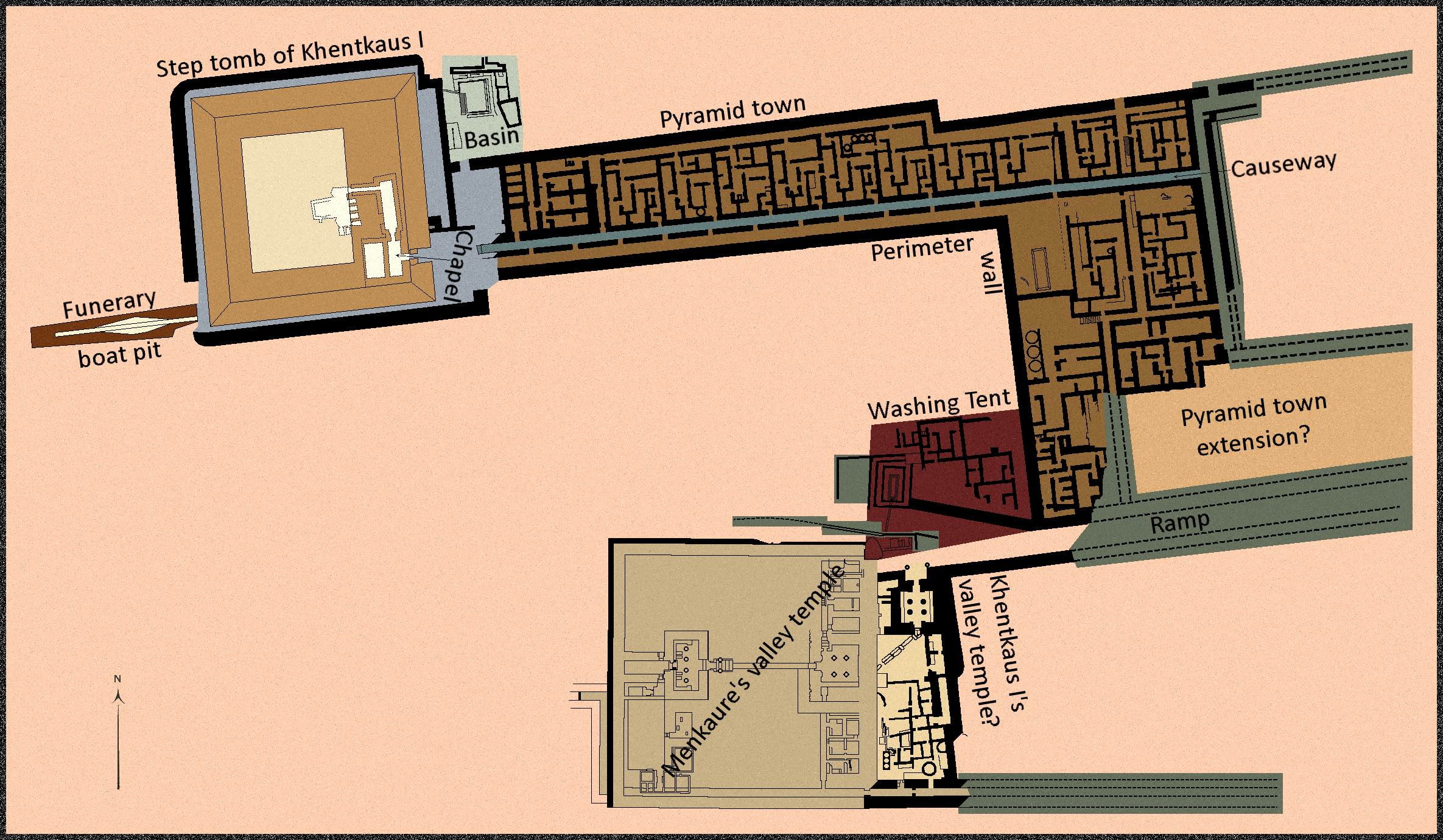
English: Khentkaus' mortuary complex, from west to east, then south to south-west: funerary boat pit, Step tomb of Khentkaus, causeway and pyramid town (east), pyramid town (south), washing tent, Khentkaus I's valley temple, and Menkaure's valley temple. |
| Date | |
| Source | Own work based on Hassan (1943) Excavations at Giza (1932–1933) and Lehner, Jones, Yeomans, Mahmoud and Olchowska (2011) "Re-examining the Khentkaues Town" in Old Kingdom, New Perspectives: Egyptian Art and Archaeology, 2750-2150 BC. |
| Author | Mr rnddude |
Licensing[edit]
I, the copyright holder of this work, hereby publish it under the following license:
This file is licensed under the Creative Commons Attribution-Share Alike 4.0 International license.
- You are free:
- to share – to copy, distribute and transmit the work
- to remix – to adapt the work
- Under the following conditions:
- attribution – You must give appropriate credit, provide a link to the license, and indicate if changes were made. You may do so in any reasonable manner, but not in any way that suggests the licensor endorses you or your use.
- share alike – If you remix, transform, or build upon the material, you must distribute your contributions under the same or compatible license as the original.
File history
Click on a date/time to view the file as it appeared at that time.
| Date/Time | Thumbnail | Dimensions | User | Comment | |
|---|---|---|---|---|---|
| current | 10:23, 24 September 2019 | | 2,370 × 1,380 (2.24 MB) | Mr rnddude (talk | contribs) | Minor clean-up, hopefully the last bit it |
| 10:19, 24 September 2019 |  | 2,370 × 1,380 (2.24 MB) | Mr rnddude (talk | contribs) | Minor wall correction | |
| 10:05, 24 September 2019 |  | 2,370 × 1,380 (2.24 MB) | Mr rnddude (talk | contribs) | Update with Lehner et al. (2011) | |
| 16:28, 23 September 2019 |  | 2,070 × 1,380 (1.93 MB) | Mr rnddude (talk | contribs) | Minor wall corrections in the valley temple | |
| 15:25, 23 September 2019 |  | 2,070 × 1,380 (1.93 MB) | Mr rnddude (talk | contribs) | Added in the basin. Missed it because Hassan changes colour in this section, and most of that area of the map is unrelated to the core structure of the tomb. | |
| 09:13, 23 September 2019 |  | 2,070 × 1,380 (1.93 MB) | Mr rnddude (talk | contribs) | Lighten BG colour to a blood-orange type. | |
| 09:04, 23 September 2019 |  | 2,070 × 1,380 (1.8 MB) | Mr rnddude (talk | contribs) | User created page with UploadWizard |
You cannot overwrite this file.
File usage on Commons
There are no pages that use this file.
File usage on other wikis
The following other wikis use this file:
- Usage on en.wikipedia.org
- Usage on fa.wikipedia.org