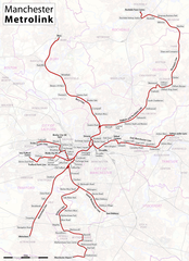
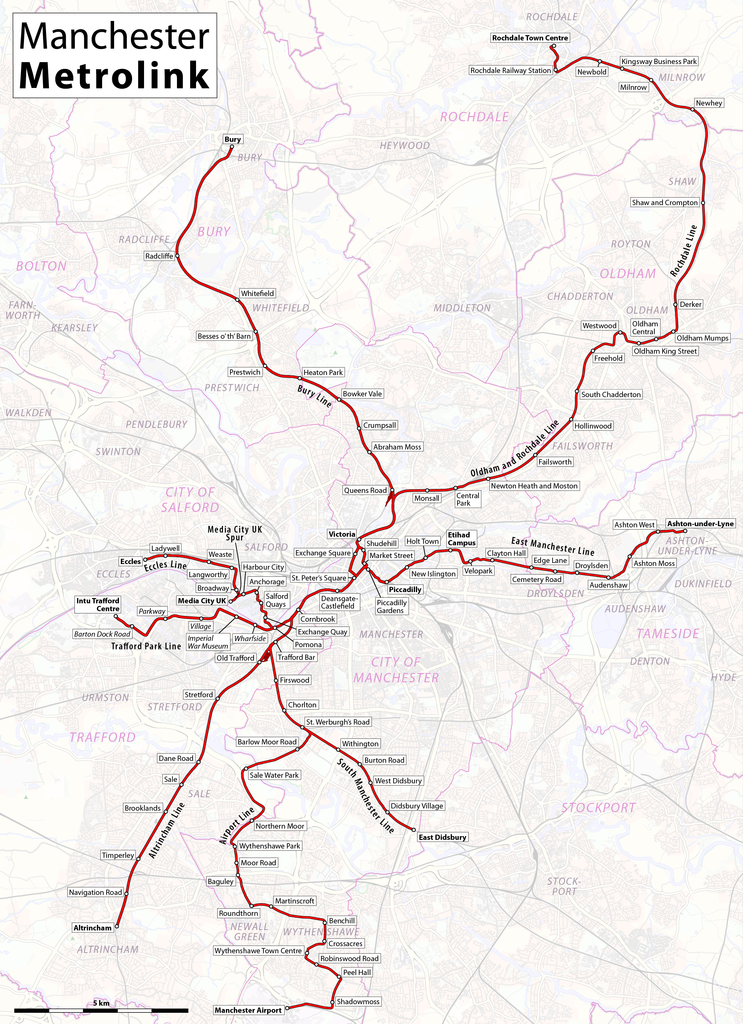
File:Map of Manchester Metrolink.png
Aller à la navigation
Aller à la recherche

Taille de cet aperçu : 435 × 599 pixels. Autres résolutions : 174 × 240 pixels | 348 × 480 pixels | 557 × 768 pixels | 743 × 1 024 pixels | 1 986 × 2 736 pixels.
Fichier d’origine (1 986 × 2 736 pixels, taille du fichier : 4,1 Mio, type MIME : image/png)
Légendes
Légendes
Ajoutez en une ligne la description de ce que représente ce fichier
| Description |
|
|||
| Date | see file history | |||
| Source | Travail personnel, using OpenStreetMap data for the background | |||
| Auteur | Maximilian Dörrbecker (Chumwa) | |||
| Autorisation (Réutilisation de ce fichier) |
All OpenStreetMap data and maps are Creative Commons "CC-BY-SA 2.0" licensed Ce fichier est disponible selon les termes de la licence Creative Commons Attribution – Partage dans les Mêmes Conditions 2.0 Générique
|
|||
| Autres versions |
|


Historique du fichier
Cliquer sur une date et heure pour voir le fichier tel qu'il était à ce moment-là.
| Date et heure | Vignette | Dimensions | Utilisateur | Commentaire | |
|---|---|---|---|---|---|
| actuel | 13 juin 2020 à 08:51 | | 1 986 × 2 736 (4,1 Mio) | Chumwa (d | contributions) | update |
| 29 janvier 2018 à 23:18 |  | 1 986 × 2 736 (4,1 Mio) | Chumwa (d | contributions) | update | |
| 18 mars 2017 à 19:35 |  | 1 986 × 2 736 (4,1 Mio) | Chumwa (d | contributions) | ||
| 1 mars 2017 à 22:13 |  | 1 986 × 2 736 (4,09 Mio) | Chumwa (d | contributions) | update | |
| 1 décembre 2016 à 22:45 |  | 1 986 × 2 736 (4,09 Mio) | Chumwa (d | contributions) | ||
| 31 décembre 2015 à 07:44 |  | 1 986 × 2 736 (3,96 Mio) | Chumwa (d | contributions) | corr | |
| 31 décembre 2015 à 03:08 |  | 1 986 × 2 736 (4,4 Mio) | G-13114 (d | contributions) | Correct spelling mistake of Piccadilly, edit out disused Moseley Street station, made clear that 2CC is not yet open | |
| 24 août 2015 à 05:35 |  | 1 986 × 2 736 (3,96 Mio) | Chumwa (d | contributions) | ||
| 11 août 2015 à 06:32 |  | 1 986 × 2 736 (3,9 Mio) | Chumwa (d | contributions) | ||
| 10 août 2015 à 20:58 |  | 1 986 × 2 736 (3,61 Mio) | Chumwa (d | contributions) |
Vous ne pouvez pas remplacer ce fichier.
Utilisations locales du fichier
Les 53 pages suivantes utilisent ce fichier :
- Tram - Europe
- Transport in Greater Manchester
- User:Chumwa/Gallery
- User:Chumwa/OgreBot/Potential transport maps/2016 December 1-10
- User:Chumwa/OgreBot/Potential transport maps/2017 March 1-10
- User:Chumwa/OgreBot/Potential transport maps/2017 March 11-20
- User:Chumwa/OgreBot/Potential transport maps/2018 January 21-31
- User:Chumwa/OgreBot/Public transport information/2015 August 1-10
- User:Chumwa/OgreBot/Public transport information/2015 August 11-20
- User:Chumwa/OgreBot/Public transport information/2015 August 21-31
- User:Chumwa/OgreBot/Public transport information/2015 December 21-31
- User:Chumwa/OgreBot/Public transport information/2016 December 1-10
- User:Chumwa/OgreBot/Public transport information/2017 March 1-10
- User:Chumwa/OgreBot/Public transport information/2017 March 11-20
- User:Chumwa/OgreBot/Public transport information/2018 January 21-31
- User:Chumwa/OgreBot/Public transport information/2020 June 11-20
- User:Chumwa/OgreBot/Transport Maps/2015 August 1-10
- User:Chumwa/OgreBot/Transport Maps/2015 August 11-20
- User:Chumwa/OgreBot/Transport Maps/2015 August 21-31
- User:Chumwa/OgreBot/Transport Maps/2015 December 21-31
- User:Chumwa/OgreBot/Transport Maps/2016 December 1-10
- User:Chumwa/OgreBot/Transport Maps/2017 March 1-10
- User:Chumwa/OgreBot/Transport Maps/2017 March 11-20
- User:Chumwa/OgreBot/Transport Maps/2018 January 21-31
- User:Chumwa/OgreBot/Transport Maps/2020 June 11-20
- User:Chumwa/OgreBot/Travel and communication maps/2016 December 1-10
- User:Chumwa/OgreBot/Travel and communication maps/2017 March 1-10
- User:Chumwa/OgreBot/Travel and communication maps/2017 March 11-20
- User:Chumwa/OgreBot/Travel and communication maps/2018 January 21-31
- User:Hoff1980/Rail transport in France/2015 August 1-10
- User:Hoff1980/Rail transport in France/2015 August 11-20
- User:Hoff1980/Rail transport in France/2015 August 21-31
- User:Hoff1980/Rail transport in France/2015 December 21-31
- User:Mattbuck/Railways/2015 August 1-10
- User:Mattbuck/Railways/2015 August 11-20
- User:Mattbuck/Railways/2015 August 21-31
- User:Mattbuck/Railways/2015 December 21-31
- User:Mattbuck/Railways/2016 December 1-10
- User:Mattbuck/Railways/2017 March 1-10
- User:Mattbuck/Railways/2017 March 11-20
- User:Mattbuck/Railways/2018 January 21-31
- User:Mattbuck/Railways/2020 June
- File:Altrincham Line Map.png
- File:Bury Line Map.png
- File:East Manchester Line.png
- File:Ecclesline.png
- File:Manchester Metrolink - Schemaplan.png
- File:Map of Manchester Metrolink.png
- File:Metrolink Airport Line Map.png
- File:Oldham & Rochdale Line Map.png
- File:South Manchester Line.png
- Category:Manchester Metrolink
- Category:Manchester Metrolink stations
Utilisations du fichier sur d’autres wikis
Les autres wikis suivants utilisent ce fichier :
- Utilisation sur cy.wikipedia.org
- Utilisation sur de.wikipedia.org
- Utilisation sur en.wikipedia.org
- Utilisation sur eo.wikipedia.org
- Utilisation sur es.wikipedia.org
- Utilisation sur fi.wikipedia.org
- Utilisation sur fr.wikipedia.org
- Utilisation sur he.wikipedia.org
- Utilisation sur id.wikipedia.org
- Utilisation sur it.wikipedia.org
- Utilisation sur ja.wikipedia.org
- Utilisation sur ko.wikipedia.org
- Utilisation sur nl.wikipedia.org
- Utilisation sur nn.wikipedia.org
- Utilisation sur no.wikipedia.org
- Utilisation sur ru.wikipedia.org
- Utilisation sur simple.wikipedia.org
- Utilisation sur th.wikipedia.org
- Utilisation sur tr.wikipedia.org
- Utilisation sur uk.wikipedia.org
- Utilisation sur www.wikidata.org
- Utilisation sur zh.wikipedia.org