File:Map of Nepal in 1782.png
Jump to navigation
Jump to search

Size of this preview: 800 × 416 pixels. Other resolutions: 320 × 167 pixels | 640 × 333 pixels | 1,024 × 533 pixels | 1,280 × 666 pixels | 3,392 × 1,765 pixels.
Original file (3,392 × 1,765 pixels, file size: 3.89 MB, MIME type: image/png)
Captions
Captions
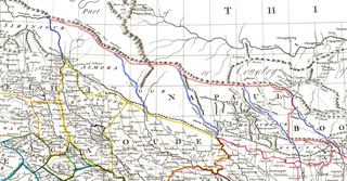
Map of Nepal in 1782 shows the border of Nepal at that time
Summary
[edit]| Description |
Zoom into this map at maps.bpl.org. The border and river (only Nepal area) coloured by me (Raju_Babu (talk · contribs)) to make comprehensible. Author: Rennell, James Publisher: Rennell, James Date: 1782 |
| Date | |
| Source | Hindoostan |
| Author | Rennell, James |
| Other versions |
.jpg)
Licensing
[edit]
This file is licensed under the Creative Commons Attribution-Share Alike 4.0 International license.
- You are free:
- to share – to copy, distribute and transmit the work
- to remix – to adapt the work
- Under the following conditions:
- attribution – You must give appropriate credit, provide a link to the license, and indicate if changes were made. You may do so in any reasonable manner, but not in any way that suggests the licensor endorses you or your use.
- share alike – If you remix, transform, or build upon the material, you must distribute your contributions under the same or compatible license as the original.
File history
Click on a date/time to view the file as it appeared at that time.
| Date/Time | Thumbnail | Dimensions | User | Comment | |
|---|---|---|---|---|---|
| current | 01:34, 18 January 2021 | | 3,392 × 1,765 (3.89 MB) | Raju Babu (talk | contribs) | Uploaded a work by Rennell, James from [https://www.flickr.com/photos/normanbleventhalmapcenter/20118721954/ Hindoostan] with UploadWizard |
You cannot overwrite this file.
File usage on Commons
There are no pages that use this file.