File:Map of Rohingya people in Rakhine State.png
Ir a la navegación
Ir a la búsqueda
Tamaño de esta previsualización: 345 × 600 píxeles. Otras resoluciones: 138 × 240 píxeles | 276 × 480 píxeles | 651 × 1132 píxeles.
Archivo original (651 × 1132 píxeles; tamaño de archivo: 61 kB; tipo MIME: image/png)
Leyendas
Leyendas
Añade una explicación corta acerca de lo que representa este archivo
Resumen[editar]
| Descripción |
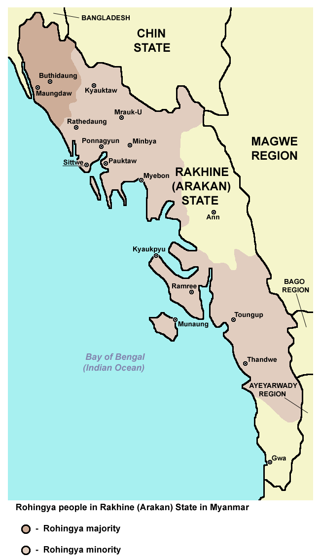
English: Rohingya people in Rakhine (Arakan) State in Myanmar. |
| Fecha | |
| Fuente | Trabajo propio |
| Autor | PANONIAN |
Licencia[editar]
Yo, el titular de los derechos de autor de esta obra, la publico en los términos de la siguiente licencia:
| Este archivo está disponible bajo la licencia Creative Commons Dedicación de Dominio Público CC0 1.0 Universal. | |
| La persona que ha asociado una obra a este documento lo dedica al dominio público mediante la cesión mundial de sus derechos bajo la ley de derechos de autor y todos los derechos legales adyacentes propios de dicha, en el ámbito permitido por ley. Puedes copiar, modificar, distribuir y reproducir el trabajo, incluso con objetivos comerciales, sin pedir aprobación del autor.
|
References[editar]
Demographic data:
- http://reliefweb.int/report/myanmar/humanitarian-crisis-deepens-arakan-state ("This is in contrast to Buthidaung and Maungdaw townships which have a large Rohingya majority.")
- http://csis.org/publication/separating-fact-fiction-about-myanmars-rohingya ("Most of this population lives in the townships of Maungdaw and Buthidaung, where Rohingya are the majority")
- http://sometimemaybe.blogspot.com/2009/07/burma-ii.html ("Fear is said to reign not only in Rakhine towns and villages but also areas with Rohingya majorities—including Maungdaw Township, where more than 90 percent of the 493,000 inhabitants are Rohingya."..."One other township in Arakan State has a large Rohingya majority—Buthidaung, where more than 80 percent of the 279,000 inhabitants are Rohingya.")
- http://library.islamweb.net/emainpage/articles/180009/mass-graves-for-myanmars-rohingya ("or even the local busses that run Buthidaung to Maungdaw, two Rohingya-majority states.")
- http://www.aljazeera.com/indepth/features/2012/08/201288114724103607.html ("or even the local busses that run from Buthidaung to Maungdaw, two Rohingya-majority states.")
- https://www.hrw.org/news/2012/11/17/burma-satellite-images-show-widespread-attacks-rohingya ("All four districts of Arakan State – Sittwe, Maungdaw, Kyauk Pyu, and Thandwe – have experienced violence since June 2012. Violence between Arakanese Buddhists and Rohingya Muslims reignited on October 21 and continued to some extent all week in 9 of the state’s 17 townships: Pauktaw, Mrauk-U, Myebon, Kyauk Pyu, Ramree, Kyauktaw, Minbya, Rathedaung, and Thandwe. Four other townships experienced serious violence in June and thereafter: Sittwe, Maungdaw, Buthidaung, and Toungop.")
- http://www.restlessbeings.org/projects/rohingya/burmese-army-allow-further-2300-rohingya-to-become-displaced ("This second round of violence that began on the 21st of October were targeted at more remote villages where, whilst Rohingya villages were found, the townships were largely Rakhine populated. In Minbya, Mrauk Oo, Pauk Taw, Kyauk Taw, Kyauk Pyu and Rathedaung.")
- http://hlaoo1980.blogspot.com/2012/06/bengali-cleansing-in-arrakan.html ("There are 17 townships in the Arrakan State. Except the Bengali-free Taunggup, Ann, and Gwa townships Bengali immigrants from the extremely-crowded Bangladesh across the border inhabit the 14 townships together with the native Buddhist Yakhines.")
- http://loveandntolerance.blogspot.com/2012/10/the-concrete-solution-for-rohingya.html ("Nearly one million Rohingyas in 14 townships of Arakan State")
- https://rohingyaonlinenewsgroup.wordpress.com/2012/10/28/president-thein-sein-ready-to-declare-a-new-rule-of-law-in-rakhine-state/ ("Before and since the timely establishment of the RNDP party, its ultimate goal has been to drive out Rohingya Muslims from all 14 townships of Rakhine state and then to establish The Great Rakhine Union State")
- https://www.usatoday.com/story/news/world/2013/03/30/myanmar-govt-religious-riots/2037853/ ("It said there were 163 incidents of violence in 15 townships in the country")
Maps of Rakhine State:
- http://www.myanmars.net/myanmar-map/rakhine.jpg
- http://www.edenhilltravels.com/wp-content/uploads/2013/08/rakhine-modified.jpg
- http://www.rfa.org/english/news/myanmar/violence-10252012182913.html/rakhine-map-new-390.jpg
- http://www.asterism.info/states/7/map.jpg
- http://www.allthingsburmese.com/images/Rakhine%20State%20Map.gif
- http://www.guideformyanmar.com/images/touristplace/rakhine_state.jpg
- https://arakanindobhasa.files.wordpress.com/2009/11/12.jpg
- http://reliefweb.int/sites/reliefweb.int/files/resources/map_2466.pdf
- http://maps.maphill.com/burma/arakan-rakhine/maps/savanna-style-map/savanna-style-map-of-arakan-rakhine.jpg
- http://maps.maphill.com/burma/arakan-rakhine/maps/satellite-map/cropped-outside/satellite-map-of-arakan-rakhine-cropped-outside.jpg
- http://maps.maphill.com/burma/arakan-rakhine/maps/shaded-relief-map/shaded-relief-map-of-arakan-rakhine.jpg
- http://www.burmalibrary.org/docs08/HRDU_YB-2008/multimedia/maps/townships.jpg
Historial del archivo
Haz clic sobre una fecha y hora para ver el archivo tal como apareció en ese momento.
| Fecha y hora | Miniatura | Dimensiones | Usuario | Comentario | |
|---|---|---|---|---|---|
| actual | 16:42 16 abr 2017 | | 651 × 1132 (61 kB) | PANONIAN (discusión | contribs.) | Reverted to version as of 12:27, 4 July 2015 (UTC) - pointless change, not an improvement, please explain on talk page why image with no border would be better |
| 00:22 14 abr 2017 |  | 620 × 1000 (59 kB) | Haffaz (discusión | contribs.) | Made legend clearer | |
| 07:09 11 abr 2017 |  | 619 × 1117 (32 kB) | Haffaz (discusión | contribs.) | removed white space and centered legend | |
| 12:27 4 jul 2015 |  | 651 × 1132 (61 kB) | PANONIAN (discusión | contribs.) | {{Information |Description ={{en|1=Rohingya people in Rakhine (Arakan) State in Myanmar.}} |Source ={{own}} |Author =PANONIAN |Date =2015 |Permission = |other_versions = }} |
No puedes sobrescribir este archivo.
Usos del archivo
Las siguientes páginas usan este archivo:
- File:Map of Maungdaw District in Rakhine State (Arakan).png
- File:Rakhine02 rohingya people.png (archivo de redirección)
.png)
Uso global del archivo
Las wikis siguientes utilizan este archivo:
- Uso en af.wikipedia.org
- Uso en azb.wikipedia.org
- Uso en bn.wikipedia.org
- Uso en ca.wikipedia.org
- Uso en de.wikipedia.org
- Uso en diq.wikipedia.org
- Uso en en.wikipedia.org
- Uso en es.wikipedia.org
- Uso en ga.wikipedia.org
- Uso en hr.wikipedia.org
- Uso en hu.wikipedia.org
- Uso en id.wikipedia.org
- Uso en is.wikipedia.org
- Uso en lt.wikipedia.org
- Uso en mk.wikipedia.org
- Uso en mnw.wikipedia.org
- Uso en pa.wikipedia.org
- Uso en pnb.wikipedia.org
- Uso en ru.wikipedia.org
- Uso en sh.wikipedia.org
- Uso en sr.wikipedia.org
- Uso en tl.wikipedia.org
- Uso en tr.wikipedia.org
- Uso en uk.wikipedia.org
- Uso en ur.wikipedia.org
- Uso en vi.wikipedia.org
- Uso en zh.wikipedia.org