File:Map of Russia - Moscow time zone.svg
跳至導覽
跳至搜尋

此 SVG 檔案的 PNG 預覽的大小:800 × 462 像素。 其他解析度:320 × 185 像素 | 640 × 369 像素 | 1,024 × 591 像素 | 1,280 × 738 像素 | 2,560 × 1,477 像素 | 1,092 × 630 像素。
原始檔案 (SVG 檔案,表面大小:1,092 × 630 像素,檔案大小:300 KB)
說明
說明
添加單行說明來描述出檔案所代表的內容

|
The boundaries on this map show the de facto situation. This is just one of several different views on the subject (see COM:NPOV). |
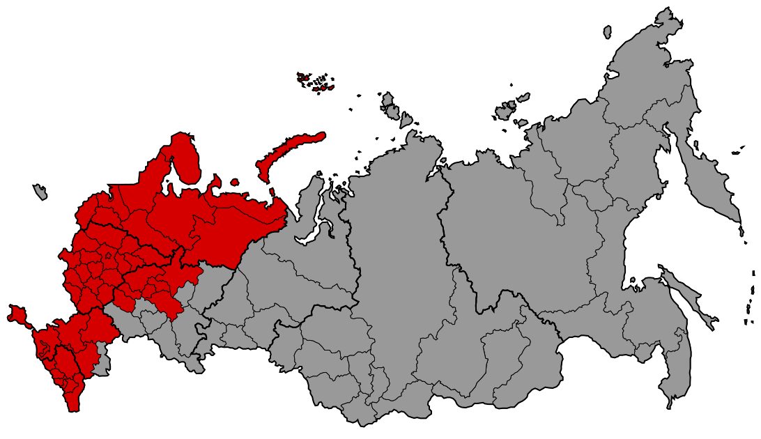
| 描述 | Map of the Moscow Time Zone (UTC+3) of Russia |
| 日期 | |
| 來源 | Based on Map of Russia - Time Zones.svg by Lokal_Profil. Colours from RTZ1.png by Niki K. |
| 作者 | Lokal_Profil |
| 授權許可 (重用此檔案) |
此檔案採用創用CC 姓名標示-相同方式分享 2.5 通用版授權條款。 姓名標示: Lokal_Profil
|
檔案歷史
點選日期/時間以檢視該時間的檔案版本。
| 日期/時間 | 縮圖 | 尺寸 | 用戶 | 備註 | |
|---|---|---|---|---|---|
| 目前 | 2022年4月7日 (四) 09:04 | | 1,092 × 630(300 KB) | ДолбоЯщер(對話 | 貢獻) | Reverted to version as of 11:40, 1 April 2018 (UTC) -- after being in MSK+1 for 2 years, Volgograd oblast returned to MSK in Dec.2020 |
| 2020年5月5日 (二) 03:16 |  | 1,092 × 630(300 KB) | Ratherous(對話 | 貢獻) | Volgograd Oblast | |
| 2018年4月1日 (日) 11:40 |  | 1,092 × 630(300 KB) | Brateevsky(對話 | 貢獻) | Reverted to version as of 05:34, 6 December 2016 (UTC) | |
| 2017年12月30日 (六) 17:00 |  | 1,092 × 630(178 KB) | Sauveteur(對話 | 貢獻) | Reverted to version as of 11:02, 28 March 2010 (UTC) | |
| 2016年12月6日 (二) 05:34 |  | 1,092 × 630(300 KB) | Alex Great(對話 | 貢獻) | Saratov Oblast now in Samara Time Zone | |
| 2016年5月8日 (日) 05:47 |  | 1,092 × 630(300 KB) | Alex Great(對話 | 貢獻) | Update to 2016 | |
| 2014年11月2日 (日) 14:04 |  | 1,092 × 630(253 KB) | Brateevsky(對話 | 貢獻) | minus Samara Oblast and Udmurtia | |
| 2014年7月22日 (二) 00:33 |  | 1,092 × 630(253 KB) | Knyaz-1988(對話 | 貢獻) | New version | |
| 2010年3月28日 (日) 11:02 |  | 1,092 × 630(178 KB) | Хинт(對話 | 貢獻) | Samara Oblast and Udmurtia joined the Moscow time zone | |
| 2009年6月13日 (六) 12:33 |  | 1,092 × 630(179 KB) | Хинт(對話 | 貢獻) | regions merged to single outline |
無法覆蓋此檔案。
檔案用途
下列8個頁面有用到此檔案:
- Time zones of Russia
- User:Chumwa/OgreBot/Potential transport maps/2016 December 1-10
- User:Chumwa/OgreBot/Potential transport maps/2016 May 1-10
- User:Chumwa/OgreBot/Transport Maps/2016 December 1-10
- User:Chumwa/OgreBot/Transport Maps/2016 May 1-10
- User:Chumwa/OgreBot/Travel and communication maps/2016 December 1-10
- User:Chumwa/OgreBot/Travel and communication maps/2016 May 1-10
- File:RTZ2.png
全域檔案使用狀況
以下其他 wiki 使用了這個檔案:
- ast.wikipedia.org 的使用狀況
- República de Crimea
- Óblast de Bélgorod
- Óblast de Briansk
- Óblast de Vladímir
- Óblast d'Ivánovo
- Óblast de Kaluga
- Óblast de Kostromá
- Óblast de Kursk
- Óblast de Riazán
- Óblast de Smolensk
- Óblast de Tambov
- Óblast de Tver
- Óblast de Tula
- Krai de Krasnodar
- Kabardia-Balkaria
- Óblast de Leningráu
- Óblast de Kírov
- Chuvasia
- Krai de Stávropol
- Óblast de Vólogda
- Óblast de Pskov
- azb.wikipedia.org 的使用狀況
檢視此檔案的更多全域使用狀況。