File:Map of Trans-African Highways.PNG
跳转到导航
跳转到搜索
本预览的尺寸:600 × 600像素。 其他分辨率:240 × 240像素 | 480 × 480像素 | 832 × 832像素。
原始文件 (832 × 832像素,文件大小:211 KB,MIME类型:image/png)
说明
说明
添加一行文字以描述该文件所表现的内容
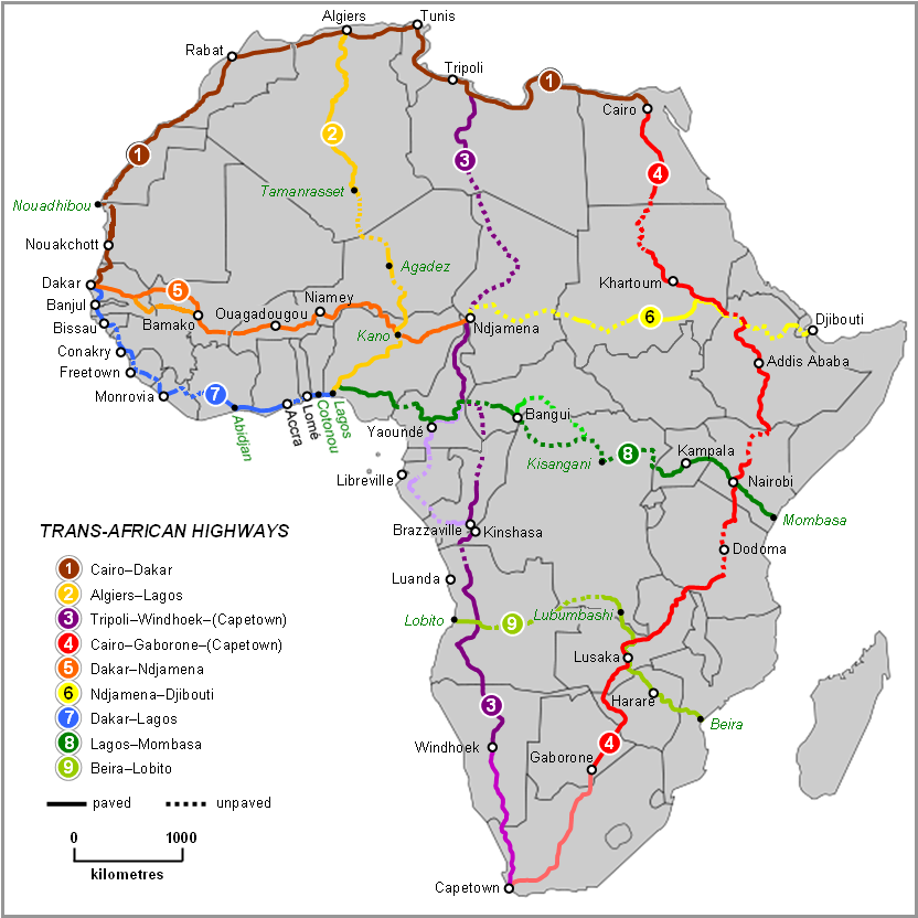
Map of Trans-African Highways 2022, per Michelin Afrique & Google Earth

|
此road map图片可使用矢量图形重新创建为SVG文件。这具有很多好处;更多信息请参见共享资源:待清理媒体。如果存在此图片的SVG格式,请将其上传,然后将此模板替换为
{{vector version available|新图片名称}}。
建议您将SVG命名为“Map of Trans-African Highways.svg”,这样在使用Vector version available(或Vva)模板时就不需要填写新图片名称参数。 |
摘要
[编辑]
| 描述 |
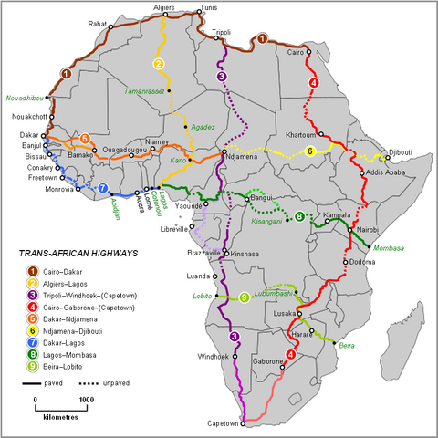
English: Map of Trans-African Highways based on data 2000 to 2003 |
| 日期 | |
| 来源 | Word doc drawing based in Wikipedia blank Africa map |
| 作者 | Rex Parry |
| 其他版本 |
|
许可协议
[编辑]
I, Rexparry sydney,本作品著作权人,特此采用以下许可协议发表本作品:

|
已授权您依据自由软件基金会发行的无固定段落及封面封底文字(Invariant Sections, Front-Cover Texts, and Back-Cover Texts)的GNU自由文件许可协议1.2版或任意后续版本的条款,复制、传播和/或修改本文件。该协议的副本请见“GNU Free Documentation License”。 |
| 本文件采用知识共享署名-相同方式共享 3.0 未本地化版本许可协议授权。 | ||
| 署名: I, Rexparry sydney | ||
| ||
| 本许可协议标签作为GFDL许可协议更新的组成部分被添加至本文件。 |
署名: I, Rexparry sydney
- 您可以自由地:
- 共享 – 复制、发行并传播本作品
- 修改 – 改编作品
- 惟须遵守下列条件:
- 署名 – 您必须对作品进行署名,提供授权条款的链接,并说明是否对原始内容进行了更改。您可以用任何合理的方式来署名,但不得以任何方式表明许可人认可您或您的使用。
- 相同方式共享 – 如果您再混合、转换或者基于本作品进行创作,您必须以与原先许可协议相同或相兼容的许可协议分发您贡献的作品。
您可以选择您需要的许可协议。
| 註解 | 該圖片含有註解:在維基媒體共享資源上查看註解 |
文件历史
点击某个日期/时间查看对应时刻的文件。
| 日期/时间 | 缩略图 | 大小 | 用户 | 备注 | |
|---|---|---|---|---|---|
| 当前 | 2023年6月19日 (一) 11:28 | | 832 × 832(211 KB) | Abdelrhman 1990(留言 | 贡献) | Map correction |
| 2022年2月6日 (日) 05:56 |  | 832 × 832(155 KB) | SounderBruce(留言 | 贡献) | Reverted to version as of 20:18, 8 November 2020 (UTC): Improper upscaling | |
| 2022年1月19日 (三) 00:45 |  | 1,922 × 1,918(1,016 KB) | Arrecife(留言 | 贡献) | 2022 update per Michelin Afrique & Google Earth | |
| 2022年1月14日 (五) 16:24 |  | 615 × 614(185 KB) | Arrecife(留言 | 贡献) | Reverted to version as of 05:53, 6 December 2019 (UTC) smaller size, but up to date | |
| 2020年11月8日 (日) 20:18 |  | 832 × 832(155 KB) | Leviavery(留言 | 贡献) | Reverted to version as of 09:25, 23 August 2019 (UTC) Much higher quality image | |
| 2019年12月6日 (五) 05:53 |  | 615 × 614(185 KB) | Arrecife(留言 | 贡献) | Updating of all roads, from Michelin Africa plus Google Earth | |
| 2019年8月23日 (五) 09:25 |  | 832 × 832(155 KB) | NordNordWest(留言 | 贡献) | adding South Sudan | |
| 2014年10月9日 (四) 00:02 |  | 832 × 832(202 KB) | Bobrayner(留言 | 贡献) | Slight corrections/updates to map, ie. Nouakchott-Nouadhibou road was completely surfaced a few years ago Morocco-Algeria border is closed; &c. | |
| 2007年7月18日 (三) 07:12 |  | 832 × 832(175 KB) | Rexparry sydney~commonswiki(留言 | 贡献) | {{Information |Description=Map of Trans-African Highways based on data 2000 to 2003 |Source=Word doc drawing based in Wikipedia blank Africa map |Date=17 July 2007 |Author=Rex Parry |Permission=Yes |other_versions= }} |
您不可以覆盖此文件。
文件用途
以下24个页面使用本文件:
- Map
- Maps of Africa
- Top 200 transport map images that should use vector graphics
- User:Chumwa/OgreBot/Potential transport maps/2019 August 21-31
- User:Chumwa/OgreBot/Potential transport maps/2019 December 1-10
- User:Chumwa/OgreBot/Transport Maps/2019 August 21-31
- User:Chumwa/OgreBot/Transport Maps/2019 December 1-10
- User:Chumwa/OgreBot/Transport Maps/2020 November 1-10
- User:Chumwa/OgreBot/Transport Maps/2022 February 1-9
- User:Chumwa/OgreBot/Transport Maps/2022 January 11-20
- User:Chumwa/OgreBot/Transport Maps/2023 June 11-20
- User:Chumwa/OgreBot/Travel and communication maps/2019 August 21-31
- User:Chumwa/OgreBot/Travel and communication maps/2019 December 1-10
- User:Chumwa/OgreBot/Travel and communication maps/2020 November 1-10
- User:Chumwa/OgreBot/Travel and communication maps/2022 February 1-9
- User:Chumwa/OgreBot/Travel and communication maps/2022 January 11-20
- User:Chumwa/OgreBot/Travel and communication maps/2023 June 11-20
- User:Magog the Ogre/Multilingual legend/2020 November 1-10
- User:Magog the Ogre/Multilingual legend/2022 February 1-9
- User:Magog the Ogre/Multilingual legend/2022 January 11-20
- User:Magog the Ogre/Multilingual legend/2023 June 11-20
- Commons:Files used on the AARoads Wiki/41
- Commons:Files used on the OpenStreetMap Wiki/17
- Category:Trans-African Highway network
全域文件用途
以下其他wiki使用此文件:
- af.wikipedia.org上的用途
- ar.wikipedia.org上的用途
- arz.wikipedia.org上的用途
- bn.wikipedia.org上的用途
- bs.wikipedia.org上的用途
- de.wikipedia.org上的用途
- en.wikipedia.org上的用途
- es.wikipedia.org上的用途
- fa.wikipedia.org上的用途
- fr.wikipedia.org上的用途
- he.wikipedia.org上的用途
- hu.wikipedia.org上的用途
- hy.wikipedia.org上的用途
- id.wikipedia.org上的用途
- it.wikipedia.org上的用途
- it.wikivoyage.org上的用途
- ja.wikipedia.org上的用途
- kk.wikipedia.org上的用途
- nl.wikipedia.org上的用途
- no.wikipedia.org上的用途
- pl.wikipedia.org上的用途
查看此文件的更多全域用途。