File:Map of Trans-African Highways.PNG
跳至導覽
跳至搜尋
預覽大小:600 × 600 像素。 其他解析度:240 × 240 像素 | 480 × 480 像素 | 832 × 832 像素。
原始檔案 (832 × 832 像素,檔案大小:211 KB,MIME 類型:image/png)
說明
說明
添加單行說明來描述出檔案所代表的內容
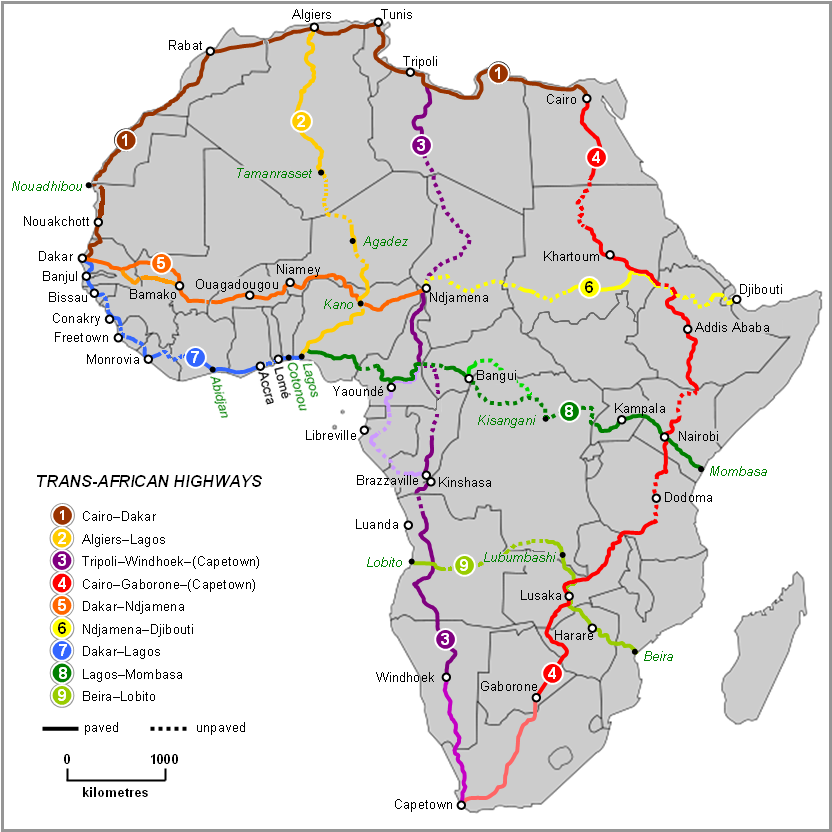
Map of Trans-African Highways 2022, per Michelin Afrique & Google Earth

|
本圖片是以PNG、GIF或JPEG格式上傳。然而,其中包含的資料或訊息,應該重新建立成可縮放向量圖形(SVG)檔案,以更有效率或更準確的方式儲存。如有可能,請上傳本圖片的SVG格式版本。在上傳之後,請修改維基各姊妹計畫中所有使用舊版圖片的條目(列在圖像連結章節中),替換為新版圖片,並在舊圖片的描述頁中加入{{Vector version available|新圖片名稱.svg}}模板,同時移除本模板。
|
摘要
[編輯]
| 描述 |
English: Map of Trans-African Highways based on data 2000 to 2003 |
| 日期 | |
| 來源 | Word doc drawing based in Wikipedia blank Africa map |
| 作者 | Rex Parry |
| 其他版本 |
|
授權條款
[編輯]
I, Rexparry sydney,此作品的版權所有人,決定用以下授權條款發佈本作品:

|
已授權您依據自由軟體基金會發行的無固定段落、封面文字和封底文字GNU自由文件授權條款1.2版或任意後續版本,對本檔進行複製、傳播和/或修改。該協議的副本列在GNU自由文件授權條款中。 |
| 此檔案採用共享創意 姓名標示-相同方式分享 3.0 未在地化版本授權條款。 | ||
| 姓名標示: I, Rexparry sydney | ||
| ||
| 已新增授權條款標題至此檔案,作為GFDL授權更新的一部份。 |
您可以選擇您需要的授權條款。
| 註解 | 該圖片含有註解:在維基媒體共享資源上查看註解 |
檔案歷史
點選日期/時間以檢視該時間的檔案版本。
| 日期/時間 | 縮圖 | 尺寸 | 用戶 | 備註 | |
|---|---|---|---|---|---|
| 目前 | 2023年6月19日 (一) 11:28 | | 832 × 832(211 KB) | Abdelrhman 1990(對話 | 貢獻) | Map correction |
| 2022年2月6日 (日) 05:56 |  | 832 × 832(155 KB) | SounderBruce(對話 | 貢獻) | Reverted to version as of 20:18, 8 November 2020 (UTC): Improper upscaling | |
| 2022年1月19日 (三) 00:45 |  | 1,922 × 1,918(1,016 KB) | Arrecife(對話 | 貢獻) | 2022 update per Michelin Afrique & Google Earth | |
| 2022年1月14日 (五) 16:24 |  | 615 × 614(185 KB) | Arrecife(對話 | 貢獻) | Reverted to version as of 05:53, 6 December 2019 (UTC) smaller size, but up to date | |
| 2020年11月8日 (日) 20:18 |  | 832 × 832(155 KB) | Leviavery(對話 | 貢獻) | Reverted to version as of 09:25, 23 August 2019 (UTC) Much higher quality image | |
| 2019年12月6日 (五) 05:53 |  | 615 × 614(185 KB) | Arrecife(對話 | 貢獻) | Updating of all roads, from Michelin Africa plus Google Earth | |
| 2019年8月23日 (五) 09:25 |  | 832 × 832(155 KB) | NordNordWest(對話 | 貢獻) | adding South Sudan | |
| 2014年10月9日 (四) 00:02 |  | 832 × 832(202 KB) | Bobrayner(對話 | 貢獻) | Slight corrections/updates to map, ie. Nouakchott-Nouadhibou road was completely surfaced a few years ago Morocco-Algeria border is closed; &c. | |
| 2007年7月18日 (三) 07:12 |  | 832 × 832(175 KB) | Rexparry sydney~commonswiki(對話 | 貢獻) | {{Information |Description=Map of Trans-African Highways based on data 2000 to 2003 |Source=Word doc drawing based in Wikipedia blank Africa map |Date=17 July 2007 |Author=Rex Parry |Permission=Yes |other_versions= }} |
無法覆蓋此檔案。
檔案用途
下列24個頁面有用到此檔案:
- Map
- Maps of Africa
- Top 200 transport map images that should use vector graphics
- User:Chumwa/OgreBot/Potential transport maps/2019 August 21-31
- User:Chumwa/OgreBot/Potential transport maps/2019 December 1-10
- User:Chumwa/OgreBot/Transport Maps/2019 August 21-31
- User:Chumwa/OgreBot/Transport Maps/2019 December 1-10
- User:Chumwa/OgreBot/Transport Maps/2020 November 1-10
- User:Chumwa/OgreBot/Transport Maps/2022 February 1-9
- User:Chumwa/OgreBot/Transport Maps/2022 January 11-20
- User:Chumwa/OgreBot/Transport Maps/2023 June 11-20
- User:Chumwa/OgreBot/Travel and communication maps/2019 August 21-31
- User:Chumwa/OgreBot/Travel and communication maps/2019 December 1-10
- User:Chumwa/OgreBot/Travel and communication maps/2020 November 1-10
- User:Chumwa/OgreBot/Travel and communication maps/2022 February 1-9
- User:Chumwa/OgreBot/Travel and communication maps/2022 January 11-20
- User:Chumwa/OgreBot/Travel and communication maps/2023 June 11-20
- User:Magog the Ogre/Multilingual legend/2020 November 1-10
- User:Magog the Ogre/Multilingual legend/2022 February 1-9
- User:Magog the Ogre/Multilingual legend/2022 January 11-20
- User:Magog the Ogre/Multilingual legend/2023 June 11-20
- Commons:Files used on the AARoads Wiki/41
- Commons:Files used on the OpenStreetMap Wiki/17
- Category:Trans-African Highway network
全域檔案使用狀況
以下其他 wiki 使用了這個檔案:
- af.wikipedia.org 的使用狀況
- ar.wikipedia.org 的使用狀況
- arz.wikipedia.org 的使用狀況
- bn.wikipedia.org 的使用狀況
- bs.wikipedia.org 的使用狀況
- de.wikipedia.org 的使用狀況
- en.wikipedia.org 的使用狀況
- es.wikipedia.org 的使用狀況
- fa.wikipedia.org 的使用狀況
- fr.wikipedia.org 的使用狀況
- he.wikipedia.org 的使用狀況
- hu.wikipedia.org 的使用狀況
- hy.wikipedia.org 的使用狀況
- id.wikipedia.org 的使用狀況
- it.wikipedia.org 的使用狀況
- it.wikivoyage.org 的使用狀況
- ja.wikipedia.org 的使用狀況
- kk.wikipedia.org 的使用狀況
- nl.wikipedia.org 的使用狀況
- no.wikipedia.org 的使用狀況
- pl.wikipedia.org 的使用狀況
檢視此檔案的更多全域使用狀況。