File:Map of Virginia Counties and Independent Cities.svg
跳至導覽
跳至搜尋

此 SVG 檔案的 PNG 預覽的大小:800 × 371 像素。 其他解析度:320 × 149 像素 | 640 × 297 像素 | 1,024 × 475 像素 | 1,280 × 594 像素 | 2,560 × 1,189 像素 | 1,260 × 585 像素。
原始檔案 (SVG 檔案,表面大小:1,260 × 585 像素,檔案大小:220 KB)
說明
說明
添加單行說明來描述出檔案所代表的內容
| 描述 |
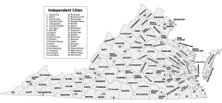
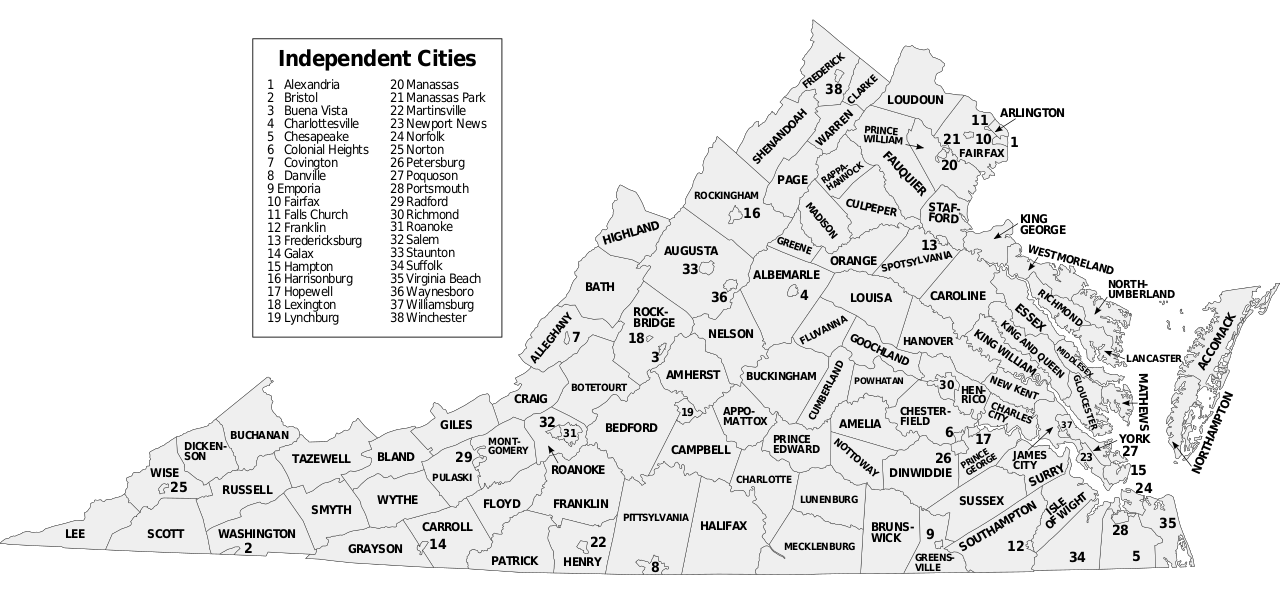
Map of Virginia counties and independent cities, SVG format. David Benbennick made the outline map modified here. For more information, see Commons:United States county locator maps. |
||
| 日期 | (UTC) | ||
| 來源 | |||
| 作者 | |||
| SVG開發 | 本vector image使用Inkscape創作。 這個SVG 檔案使用了內置文字,可以使用任何文字編輯器輕鬆翻譯。
|
此檔案採用創用CC 姓名標示-相同方式分享 3.0 未在地化版本授權條款。
- 您可以自由:
- 分享 – 複製、發佈和傳播本作品
- 重新修改 – 創作演繹作品
- 惟需遵照下列條件:
- 姓名標示 – 您必須指名出正確的製作者,和提供授權條款的連結,以及表示是否有對內容上做出變更。您可以用任何合理的方式來行動,但不得以任何方式表明授權條款是對您許可或是由您所使用。
- 相同方式分享 – 如果您利用本素材進行再混合、轉換或創作,您必須基於如同原先的相同或兼容的條款,來分布您的貢獻成品。
原始上傳日誌
[編輯]
This image is a derivative work of the following images:
- Virginia counties and independent cities map.gif licensed with Cc-by-sa-3.0-migrated-with-disclaimers, GFDL-en
- 2006-10-16T20:34:33Z JosN 1009x491 (71702 Bytes) Map of Virginia counties and independant cities.
- Map of Virginia highlighting Floyd County.svg licensed with PD-self
- 2006-02-12T17:43:56Z David Benbennick 7486x3247 (228776 Bytes) {{subst:User:Dbenbenn/clm|county=Floyd County|state=Virginia|type=county}}
Uploaded with derivativeFX
檔案歷史
點選日期/時間以檢視該時間的檔案版本。
| 日期/時間 | 縮圖 | 尺寸 | 使用者 | 備註 | |
|---|---|---|---|---|---|
| 目前 | 2016年11月8日 (二) 21:08 | | 1,260 × 585(220 KB) | Offnfopt(留言 | 貢獻) | removed left over boundary from defunct city removed in previous edit and centered Bedford text |
| 2016年11月8日 (二) 05:22 |  | 1,260 × 585(219 KB) | Offnfopt(留言 | 貢獻) | Update per request @ W:WP:GL/MAP Bedford is no longer a city so removing from list | |
| 2009年9月15日 (二) 18:43 |  | 1,260 × 585(742 KB) | Soundoftoday(留言 | 貢獻) | Fit to legal-size paper | |
| 2009年9月15日 (二) 18:36 |  | 7,488 × 3,249(741 KB) | Soundoftoday(留言 | 貢獻) | {{Information |Description=Map of Virginia counties and independent cities. David Benbennick made the outline map modified here. For more information, see Commons:United States county locator maps. |Source=*[[:File:Virginia_countie |
無法覆蓋此檔案。
檔案用途
全域檔案使用狀況
以下其他 wiki 使用了這個檔案:
- bjn.wikipedia.org 的使用狀況
- cy.wikipedia.org 的使用狀況
- en.wikipedia.org 的使用狀況
- fa.wikipedia.org 的使用狀況
- fi.wikipedia.org 的使用狀況
- frr.wikipedia.org 的使用狀況
- hu.wikipedia.org 的使用狀況
- id.wikipedia.org 的使用狀況
- pt.wikipedia.org 的使用狀況
- ro.wikipedia.org 的使用狀況
- ru.wikipedia.org 的使用狀況
- sq.wikipedia.org 的使用狀況
- tr.wikipedia.org 的使用狀況
- zh.wikipedia.org 的使用狀況