File:Map of administrative divisions of Artsakh (2020).png
Jump to navigation
Jump to search

Size of this preview: 419 × 599 pixels. Other resolutions: 168 × 240 pixels | 335 × 480 pixels | 537 × 768 pixels | 1,203 × 1,721 pixels.
Original file (1,203 × 1,721 pixels, file size: 150 KB, MIME type: image/png)
Captions
Captions
Add a one-line explanation of what this file represents
Summary[edit]
.png&action=edit§ion=1)
| Description |
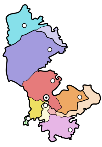
Русский: Административно-территориальное деление Нагорно-Карабахской Республики. Тёмным показаны территории, контролируемые Азербайджаном, прочие контролируются Нагорно-Карабахской Республикой. |
| Date | |
| Source | Own work |
| Author | FHen |
Licensing[edit]
.png&action=edit§ion=2)
FHen at Russian Wikipedia, the copyright holder of this work, hereby publishes it under the following licenses:

|
Permission is granted to copy, distribute and/or modify this document under the terms of the GNU Free Documentation License, Version 1.2 or any later version published by the Free Software Foundation; with no Invariant Sections, no Front-Cover Texts, and no Back-Cover Texts. A copy of the license is included in the section entitled GNU Free Documentation License. |
This file is licensed under the Creative Commons Attribution-Share Alike 3.0 Unported license.
Attribution: FHen at Russian Wikipedia
- You are free:
- to share – to copy, distribute and transmit the work
- to remix – to adapt the work
- Under the following conditions:
- attribution – You must give appropriate credit, provide a link to the license, and indicate if changes were made. You may do so in any reasonable manner, but not in any way that suggests the licensor endorses you or your use.
- share alike – If you remix, transform, or build upon the material, you must distribute your contributions under the same or compatible license as the original.
You may select the license of your choice.
Original upload log[edit]
.png&action=edit§ion=3)
The original description page was here. All following user names refer to ru.wikipedia.
- 2008-01-15 22:22 FHen 932×1192× (136137 bytes) {{Изображение | Описание = Административно-территориальное деление НКР. Тёмным показаны территории, подконтрольные Азерьайджану | Автор
File history
Click on a date/time to view the file as it appeared at that time.
| Date/Time | Thumbnail | Dimensions | User | Comment | |
|---|---|---|---|---|---|
| current | 06:27, 16 July 2023 | | 1,203 × 1,721 (150 KB) | Headgo (talk | contribs) | Reverted to version as of 21:40, 24 December 2020 (UTC) the correct image of administrative division does not match the current description in some articles in wikipedia (at least in RU), where this image is used. So, returning previous version for now, and come back to it when usage improved |
| 06:08, 16 July 2023 |  | 932 × 1,192 (133 KB) | Headgo (talk | contribs) | Reverted to version as of 10:15, 21 May 2010 (UTC) - Administrative division of Artsakh / NKR was not impacted by war, it remained the same, only the controlled area was reduced, but according to NKR Constitution and Administrative Division Law, it didn't change | |
| 21:40, 24 December 2020 |  | 1,203 × 1,721 (150 KB) | Taron Saharyan (talk | contribs) | цветовые уточнения | |
| 15:19, 5 December 2020 |  | 1,203 × 1,721 (151 KB) | Golden (talk | contribs) | remade the map with better style and more accurate borders | |
| 09:23, 4 December 2020 |  | 635 × 855 (42 KB) | BasilLeaf (talk | contribs) | Claimed and controlled territories after the 2020 War. | |
| 10:15, 21 May 2010 |  | 932 × 1,192 (133 KB) | Rubinbot (talk | contribs) | {{BotMoveToCommons|ru.wikipedia|year={{subst:CURRENTYEAR}}|month={{subst:CURRENTMONTHNAME}}|day={{subst:CURRENTDAY}}}} {{Information |Description={{ru|[[:ru:Административно-территориальное деление Нагорно-Ка |
You cannot overwrite this file.
File usage on Commons
The following 2 pages use this file:
- File:Map of Artsakh.png (file redirect)
- File:NKR.png (file redirect)
File usage on other wikis
The following other wikis use this file:
- Usage on be-tarask.wikipedia.org
- Usage on be.wikipedia.org
- Usage on fa.wikipedia.org
- Usage on fr.wikipedia.org
- Usage on hu.wikipedia.org
- Usage on it.wikipedia.org
- Usage on it.wikivoyage.org
- Usage on pt.wikipedia.org
- Usage on ru.wikipedia.org
- Usage on uk.wikipedia.org
- Usage on zh.wikipedia.org
.png&oldid=783676598)