File:Map of old Bavaria.PNG
Jump to navigation
Jump to search

Size of this preview: 439 × 599 pixels. Other resolutions: 176 × 240 pixels | 352 × 480 pixels | 563 × 768 pixels | 750 × 1,024 pixels | 1,351 × 1,844 pixels.
Original file (1,351 × 1,844 pixels, file size: 500 KB, MIME type: image/png)
Captions
Captions
Add a one-line explanation of what this file represents
Summary
[edit]
| Description |
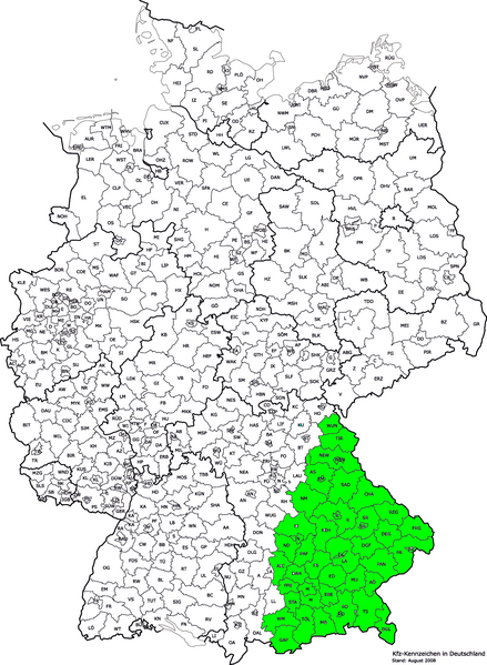
Hrvatski: područje Stare Bavarske unutar Njemačke English: Map of Old Bavaria inside Germany |
| Date | (UTC) |
| Source |
This file was derived from: Kfz-Kennzeichen Deutschlands.png:  |
| Author |
|
| This is a retouched picture, which means that it has been digitally altered from its original version. Modifications: marked Old bavaria areas. The original can be viewed here: Kfz-Kennzeichen Deutschlands.png:
|
Licensing
[edit]
I, the copyright holder of this work, hereby publish it under the following license:
This file is licensed under the Creative Commons Attribution 2.5 Generic license.
- You are free:
- to share – to copy, distribute and transmit the work
- to remix – to adapt the work
- Under the following conditions:
- attribution – You must give appropriate credit, provide a link to the license, and indicate if changes were made. You may do so in any reasonable manner, but not in any way that suggests the licensor endorses you or your use.
Original upload log
[edit]
This image is a derivative work of the following images:
- File:Kfz-Kennzeichen_Deutschlands.png licensed with Cc-by-2.5
- 2011-07-30T17:48:54Z NordNordWest 1351x1844 (440007 Bytes) update
- 2008-08-01T12:04:02Z NordNordWest 1351x1844 (440344 Bytes) Kreisreform Sachsen August 2008
- 2007-08-03T08:19:47Z Fremantleboy 1351x1844 (394175 Bytes)
- 2007-08-03T08:18:22Z Fremantleboy 2814x3841 (1138459 Bytes)
- 2007-06-28T16:19:03Z Fremantleboy 1351x1844 (395329 Bytes)
- 2007-05-25T19:13:46Z Fremantleboy 2814x3841 (1145080 Bytes) == Beschreibung == {{Information |Description=Map of German license plates |Source=own work on base of image:Landkreise.svg by [[user:DieBuche]] |Date=24. May 2007 - 24. Mai 2007 |Author=[[user:fremantleboy]] M. Stadthaus |Pe
- 2007-05-24T15:56:15Z Fremantleboy 2814x3841 (1139626 Bytes) {{Information |Description=Map of German license plates |Source=own work - selbst erstellt |Date=24. May 2007 - 24. Mai 2007 |Author=[[user:fremantleboy]] M. Stadthaus |Permission= |other_versions=[Image:Kfz-Kennzeichen_Deuts
Uploaded with derivativeFX
File history
Click on a date/time to view the file as it appeared at that time.
| Date/Time | Thumbnail | Dimensions | User | Comment | |
|---|---|---|---|---|---|
| current | 08:17, 12 May 2012 | | 1,351 × 1,844 (500 KB) | Quahadi (talk | contribs) | == {{int:filedesc}} == {{Information |Description={{hr|područje Stare Bavarske unutar Njemačke}}{{en|Map of Old Bavaria inside Germany}} |Source={{Derived from|Kfz-Kennzeichen_Deutschlands.png|display=50}} |Date=2012-05-12 08:10 (UTC) |Author=*[[:Fil... |
You cannot overwrite this file.
File usage on Commons
The following page uses this file:
- File:Map of old Bavaria .PNG (file redirect)
File usage on other wikis
The following other wikis use this file:
- Usage on hr.wikipedia.org