File:Map of the Barbary states in 1707.jpg
Jump to navigation
Jump to search
Size of this preview: 799 × 342 pixels. Other resolutions: 320 × 137 pixels | 640 × 274 pixels | 1,024 × 438 pixels | 1,280 × 548 pixels | 2,560 × 1,096 pixels | 4,831 × 2,068 pixels.
Original file (4,831 × 2,068 pixels, file size: 2.27 MB, MIME type: image/jpeg)
Captions
Captions
Add a one-line explanation of what this file represents
Summary
[edit]| Description |
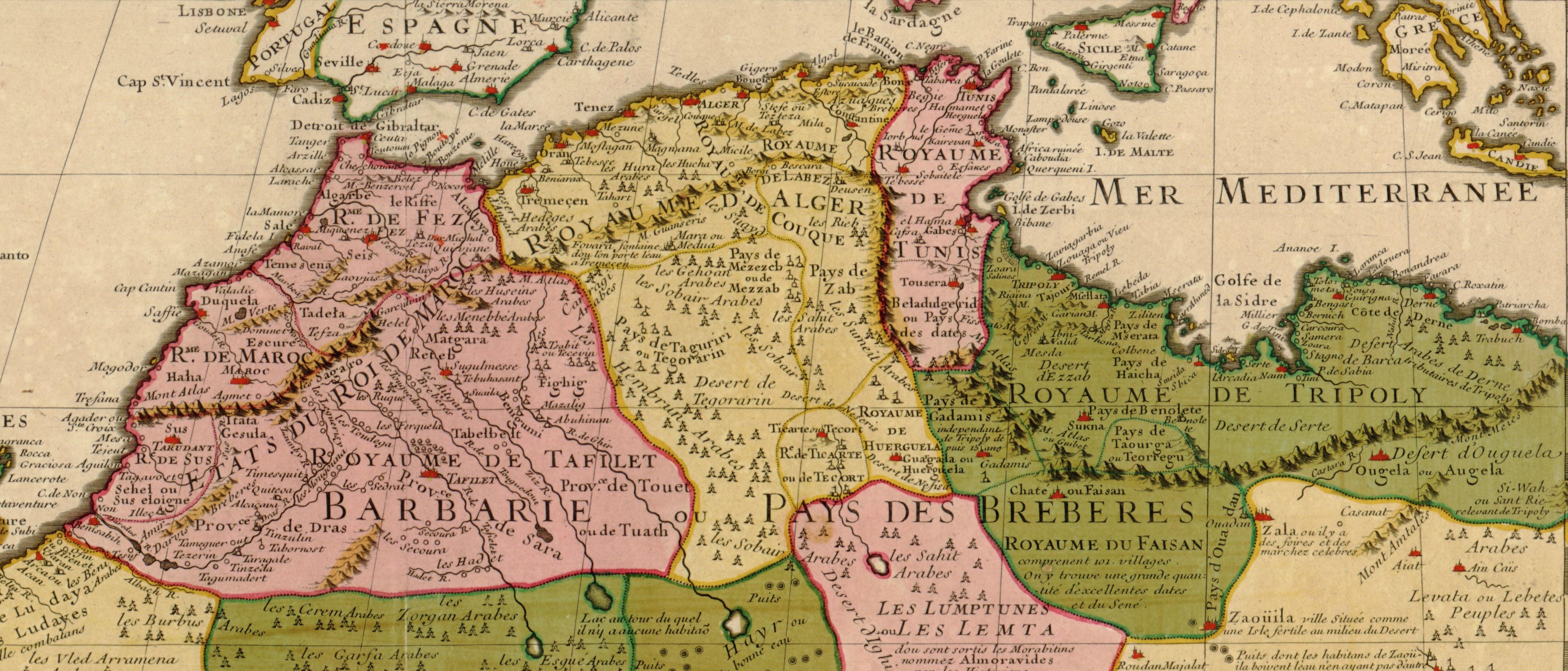
English: English: Map of the Barbary States in 1707 : Croped from File:Guillaume Delisle North West Africa 1707.jpg
Source : Library of Congress Geography and Map Division; Call Number G8220 1707 .L5
|
|||||||||||||||||||||||
| Date | ||||||||||||||||||||||||
| Source | File:Guillaume Delisle North West Africa 1707.jpg | |||||||||||||||||||||||
| Author |
|
|||||||||||||||||||||||


Licensing
[edit]
|
This work is in the public domain in its country of origin and other countries and areas where the copyright term is the author's life plus 70 years or fewer. This work is in the public domain in the United States because it was published (or registered with the U.S. Copyright Office) before January 1, 1929. | |
| This file has been identified as being free of known restrictions under copyright law, including all related and neighboring rights. | |
File history
Click on a date/time to view the file as it appeared at that time.
| Date/Time | Thumbnail | Dimensions | User | Comment | |
|---|---|---|---|---|---|
| current | 17:02, 20 September 2023 | | 4,831 × 2,068 (2.27 MB) | Nourerrahmane (talk | contribs) | Uploaded a work by {{Creator:Guillaume Delisle}} from File:Guillaume Delisle North West Africa 1707.jpg with UploadWizard |
You cannot overwrite this file.
File usage on Commons
There are no pages that use this file.
File usage on other wikis
The following other wikis use this file:
- Usage on en.wikipedia.org