File:Map of the European Parliament election (2014) (United Kingdom).svg
Jump to navigation
Jump to search

Size of this PNG preview of this SVG file: 375 × 600 pixels. Other resolutions: 150 × 240 pixels | 300 × 480 pixels | 480 × 768 pixels | 640 × 1,024 pixels | 1,280 × 2,048 pixels | 500 × 800 pixels.
Original file (SVG file, nominally 500 × 800 pixels, file size: 234 KB)
Captions
Captions
Add a one-line explanation of what this file represents
Summary[edit]
| Description |
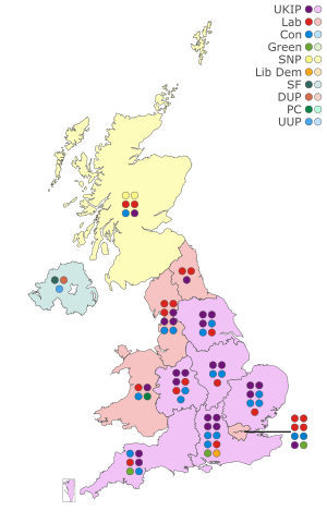
English: Map of the results for the European Parliament election, 2014 in the United Kingdom. Data is from: BBC News. |
||
| Date | |||
| Source |
Own work reference map: File:UK European Parliament constituency.svg |
||
| Author |
JDuggan101 reference map: Zmiley |
||
| Permission (Reusing this file) |
|
||
| SVG development |

_(United_Kingdom).svg&action=edit§ion=1)
File history
Click on a date/time to view the file as it appeared at that time.
| Date/Time | Thumbnail | Dimensions | User | Comment | |
|---|---|---|---|---|---|
| current | 20:57, 25 May 2019 | | 500 × 800 (234 KB) | SD604 (talk | contribs) | Moved seats in South East. |
| 16:35, 19 May 2019 |  | 500 × 800 (234 KB) | SD604 (talk | contribs) | Fixed colour key. | |
| 16:14, 19 May 2019 |  | 500 × 800 (234 KB) | SD604 (talk | contribs) | The previous version has an incorrect key that states the Greens are on two when it is three: created a new version which is more Visible and basic. | |
| 13:13, 19 May 2019 |  | 575 × 575 (774 KB) | MOTORAL1987 (talk | contribs) | Reverted to version as of 21:00, 16 May 2019 (UTC) The style of the map looks more basic than the previous one it was clearer to read with the large square coloured blocks and had the SNP colour in a lighter shade | |
| 23:05, 18 May 2019 |  | 500 × 800 (268 KB) | SD604 (talk | contribs) | Updated map | |
| 21:00, 16 May 2019 |  | 575 × 575 (774 KB) | MOTORAL1987 (talk | contribs) | Reverted to version as of 21:19, 19 October 2018 (UTC) | |
| 13:01, 10 February 2019 |  | 1,000 × 1,000 (218 KB) | SD604 (talk | contribs) | Updated. | |
| 21:19, 19 October 2018 |  | 575 × 575 (774 KB) | SD604 (talk | contribs) | {{Information |description ={{en|1=Map of the results for the European Parliament election, 2014 in the United Kingdom. Data is from: [https://www.bbc.co.uk/news/events/vote2014/eu-uk-results]}} |date =2018-10-19 |source ={{own}} |author =User:JDuggan101 |permission ={{PD-user-en|JDuggan101}} }} Category:Maps of the United Kingdom |
You cannot overwrite this file.
File usage on Commons
The following 3 pages use this file:
_(United_Kindgdom).svg&redirect=no)
File usage on other wikis
The following other wikis use this file:
- Usage on fi.wikipedia.org
- Usage on fr.wikipedia.org
_(United_Kingdom).svg&oldid=719184571)