File:Map of the Imperial Circles (1560)-en.svg
跳至導覽
跳至搜尋

此 SVG 檔案的 PNG 預覽的大小:613 × 600 像素。 其他解析度:245 × 240 像素 | 491 × 480 像素 | 785 × 768 像素 | 1,046 × 1,024 像素 | 2,093 × 2,048 像素 | 1,165 × 1,140 像素。
原始檔案 (SVG 檔案,表面大小:1,165 × 1,140 像素,檔案大小:336 KB)
說明
說明
添加單行說明來描述出檔案所代表的內容
摘要
[編輯]| 描述 |
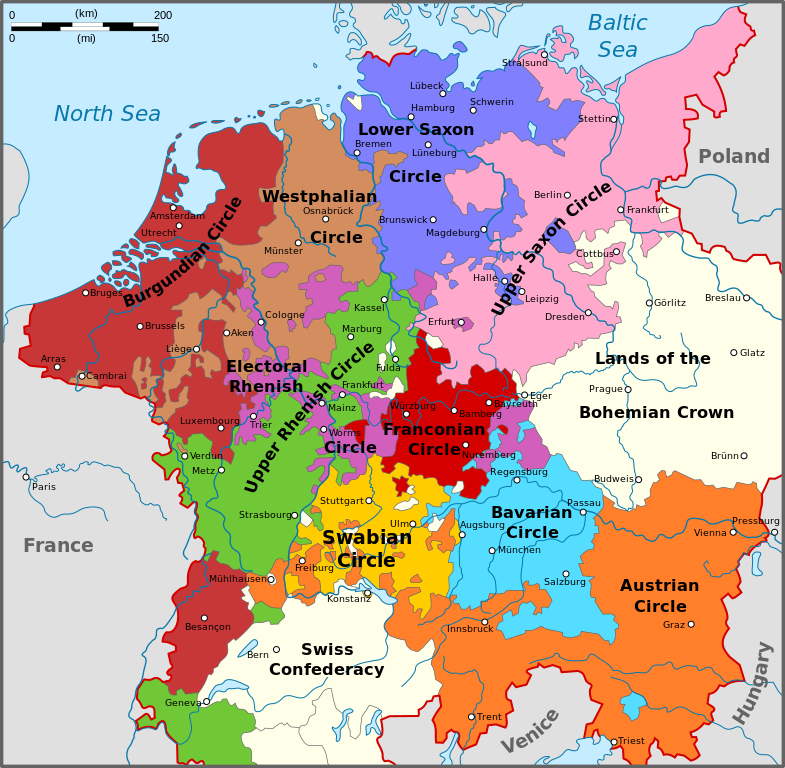
English: Map of the Imperial Circles after the Transaction of Augsburg (1548). English version.
Nederlands: Kaart van de Kreitsen na de Transactie van Augsburg (1548). Engelse versie.
Hrvatski: Karta okružja Svetog Rimskog Carstva nakon Augsburškog prijenosa iz 1548. Engleska inačica |
| 日期 | |
| 來源 | 自己的作品 |
| 作者 | Sir Iain |
| 其他版本 |
[] 1512[編輯]
1560[編輯]
|
-bg.png)
-de.png)
-en.png)
-fr.svg)
.png)
-de.svg)
-en.svg)
-es.svg)
-la.svg)
-nl.svg)
-en.svg&action=edit§ion=1)
授權條款
[編輯]-en.svg&action=edit§ion=2)
我,本作品的著作權持有者,決定用以下授權條款發佈本作品:
此檔案採用創用CC 姓名標示-相同方式分享 3.0 未在地化版本授權條款。
- 您可以自由:
- 分享 – 複製、發佈和傳播本作品
- 重新修改 – 創作演繹作品
- 惟需遵照下列條件:
- 姓名標示 – 您必須指名出正確的製作者,和提供授權條款的連結,以及表示是否有對內容上做出變更。您可以用任何合理的方式來行動,但不得以任何方式表明授權條款是對您許可或是由您所使用。
- 相同方式分享 – 如果您利用本素材進行再混合、轉換或創作,您必須基於如同原先的相同或兼容的條款,來分布您的貢獻成品。

|
已授權您依據自由軟體基金會發行的無固定段落、封面文字和封底文字GNU自由文件授權條款1.2版或任意後續版本,對本檔進行複製、傳播和/或修改。該協議的副本列在GNU自由文件授權條款中。 |
您可以選擇您需要的授權條款。
檔案歷史
點選日期/時間以檢視該時間的檔案版本。
| 日期/時間 | 縮圖 | 尺寸 | 使用者 | 備註 | |
|---|---|---|---|---|---|
| 目前 | 2010年8月14日 (六) 16:34 | | 1,165 × 1,140(336 KB) | Sir Iain(留言 | 貢獻) | The upper-Palatinate was actually part of the Electoral Rhenish Circle, contrary to almost all of the existing maps. |
| 2010年6月29日 (二) 10:42 |  | 1,165 × 1,140(332 KB) | Sir Iain(留言 | 貢獻) | Changed text on path to objects. Text on path wouldn't display correctly. | |
| 2010年6月29日 (二) 10:37 |  | 1,165 × 1,140(279 KB) | Sir Iain(留言 | 貢獻) | {{Information |Description={{en|1=Map of the Imperial Circles after the Transaction of Augsburg (1548). English version.}} {{nl|1=Kaart van de Kreitsen na de Transactie van Augsburg (1548). Engelse versie.}} |Source={{own}} |Author=[[User:Sir Iain|Sir Iai |
無法覆蓋此檔案。
檔案用途
下列13個頁面有用到此檔案:
- File:Map of the Imperial Circles (1512)-bg.png
- File:Map of the Imperial Circles (1512)-de.png
- File:Map of the Imperial Circles (1512)-en.png
- File:Map of the Imperial Circles (1512)-fr.svg
- File:Map of the Imperial Circles (1560)-EN.svg (檔案重新導向)
- File:Map of the Imperial Circles (1560)-de.svg
- File:Map of the Imperial Circles (1560)-en.svg
- File:Map of the Imperial Circles (1560)-es.svg
- File:Map of the Imperial Circles (1560)-la.svg
- File:Map of the Imperial Circles (1560)-nl.svg
- File:Német-római Birodalom körzetei (1512).png
- Template:Other versions/Map of the Imperial Circles
- Category:Reichskreise
-EN.svg&redirect=no)
全域檔案使用狀況
以下其他 wiki 使用了這個檔案:
- az.wikipedia.org 的使用狀況
- ca.wikipedia.org 的使用狀況
- cs.wikipedia.org 的使用狀況
- el.wikipedia.org 的使用狀況
- en.wikipedia.org 的使用狀況
- et.wikipedia.org 的使用狀況
- fi.wikipedia.org 的使用狀況
- hr.wikipedia.org 的使用狀況
- id.wikipedia.org 的使用狀況
- ja.wikipedia.org 的使用狀況
- ko.wikipedia.org 的使用狀況
- lt.wikipedia.org 的使用狀況
- Senoji konfederacija
- Cešyno kunigaikštystė
- Nysos kunigaikštystė
- Racibužo kunigaikštystė
- Opolės kunigaikštystė
- Bžego kunigaikštystė
- Legnicos kunigaikštystė
- Gloguvo kunigaikštystė
- Parmos hercogystė
- Milano hercogystė
- Čekijos karalystė
- Monferato marka
- Frankonijos imperinė apygarda
- Austrijos imperinė apygarda
- Šablonas:Šventosios Romos imperijos teritorijos
- Burgundijos imperinė apygarda
- Žemutinio Reino-Vestfalijos imperinė apygarda
- Italijos karalystė (viduramžiai)
- Moravijos markgrafystė
- lv.wikipedia.org 的使用狀況
- no.wikipedia.org 的使用狀況
- pt.wikipedia.org 的使用狀況
- sh.wikipedia.org 的使用狀況
- sr.wikipedia.org 的使用狀況
- tr.wikipedia.org 的使用狀況
- uk.wikipedia.org 的使用狀況
檢視此檔案的更多全域使用狀況。
-en.svg)
-en.svg&oldid=606469070)