File:Map of the Navajo Volcanic Fields.jpg
跳至導覽
跳至搜尋

預覽大小:523 × 599 像素。 其他解析度:209 × 240 像素 | 419 × 480 像素 | 670 × 768 像素 | 893 × 1,024 像素 | 1,280 × 1,467 像素。
原始檔案 (1,280 × 1,467 像素,檔案大小:568 KB,MIME 類型:image/jpeg)
說明
說明
添加單行說明來描述出檔案所代表的內容
| 描述 |
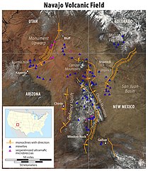
Deutsch: Karte der Navajo Volcanic Fields
English: Map of the Navajo Volcanic Field
|
|||
| 日期 | ||||
| 來源 |
自己的作品, using the following information:
|
|||
| 作者 | Maximilian Dörrbecker (Chumwa) | |||
| 授權許可 (重用此檔案) |
我,本作品的著作權持有者,決定用以下授權條款發佈本作品: 此檔案採用創用CC 姓名標示-相同方式分享 2.5 通用版授權條款。
Sie dürfen das Bild zu den folgenden Bedingungen nutzen:
|
|||
| 其他版本 |
|


檔案歷史
點選日期/時間以檢視該時間的檔案版本。
| 日期/時間 | 縮圖 | 尺寸 | 用戶 | 備註 | |
|---|---|---|---|---|---|
| 目前 | 2011年5月24日 (二) 14:49 | | 1,280 × 1,467(568 KB) | Chumwa(對話 | 貢獻) | {{Information |Description= *{{de|Karte der Navajo Volcanic Fields :Zur Erläuterung: :* Monoklinalen mit Richtung :* Minette :* serpentinisierte [[ |
無法覆蓋此檔案。
檔案用途
下列3個頁面有用到此檔案:
全域檔案使用狀況
以下其他 wiki 使用了這個檔案:
- arz.wikipedia.org 的使用狀況
- ceb.wikipedia.org 的使用狀況
- cs.wikipedia.org 的使用狀況
- de.wikipedia.org 的使用狀況
- en.wikipedia.org 的使用狀況
- fa.wikipedia.org 的使用狀況
- fr.wikipedia.org 的使用狀況
- lld.wikipedia.org 的使用狀況
- vi.wikipedia.org 的使用狀況
- www.wikidata.org 的使用狀況
- zh.wikipedia.org 的使用狀況
詮釋資料
分類:
- Geographic Overlays
- Geological maps of the United States
- Geography of the Southwestern United States
- Mountain ranges of Colorado
- Mountain ranges of New Mexico
- Mountain ranges of Arizona
- Mountain ranges of Utah
- Colorado Plateau region of Colorado
- Colorado Plateau region of New Mexico
- San Juan River (Colorado River tributary)
- Gallup, New Mexico
- Colorado Plateau region of Arizona
- Colorado Plateau region of Utah
- Agathla Peak
- Maps of Navajo Volcanic Field
- Maps of Canyon de Chelly National Monument
- Carrizo Mountains
- Lukachukai Mountains
- Chuska Mountains
- Four Corners (United States)
- Maps of Monument Valley
- Window Rock, Arizona
- Navajo Volcanic Field
- Shiprock
- Landforms on the Navajo Nation
- Kayenta, Arizona
- Black Mesa (Apache-Navajo Counties, Arizona)
- Laguña Creek
- U.S. Route 160 in Arizona
- Chinle, Arizona
- Chinle Creek
- Beautiful Valley (Arizona)
- Defiance Plateau
- Defiance Uplift
- Puerco River
- Plateaus of Arizona
- Plateaus of New Mexico
- Rivers of Arizona
- Rivers of New Mexico
- Rivers of Utah
- Rivers of Colorado
- Apache County, Arizona
- McKinley County, New Mexico
- Maps of volcanoes in the United States
- Volcanoes in Utah
- Volcanoes in Colorado
- Volcanoes in Arizona
- Volcanic fields in New Mexico
- Volcanology of Arizona
- Volcanology of Colorado
- Extensional regime
- Geological maps of Utah
- Geological maps of Arizona
- Geological maps of Colorado
- Geological maps of New Mexico
- Monoclines in the United States
- Mafic rocks in Utah
- Ultramafic rocks in Utah