File:Map of the Samanid amirate at the death of Nasr II, 943.svg
跳转到导航
跳转到搜索

此SVG文件的PNG预览的大小:800 × 562像素。 其他分辨率:320 × 225像素 | 640 × 450像素 | 1,024 × 720像素 | 1,280 × 900像素 | 2,560 × 1,800像素 | 1,603 × 1,127像素。
原始文件 (SVG文件,尺寸为1,603 × 1,127像素,文件大小:6.95 MB)
说明
说明
添加一行文字以描述该文件所表现的内容
摘要[编辑]
| 描述 |
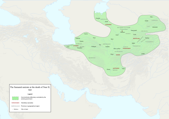
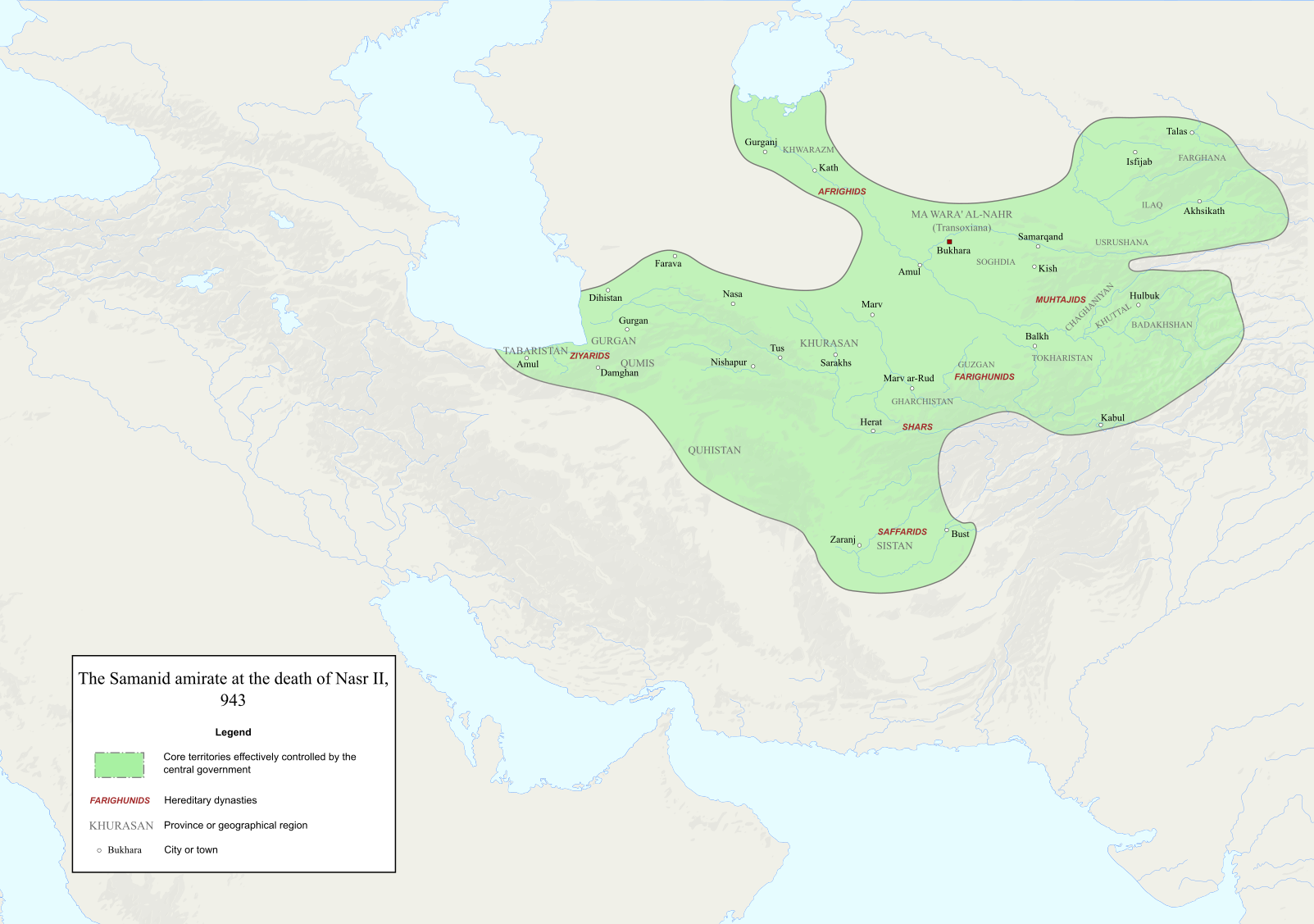
English: Map of the Samanid amirate at the death of Nasr II. |
| 来源 |
Map is mainly based on two maps of mid 10th-century Central Asia under the Samanids in the pages 23 and 25 of An Historical Atlas of Central Asia, written by Yuri Bregel and published by Brill, supplied by NAṢR (I) B. AḤMAD (I) B. ESMĀʿIL [1] and Frye, R. N. (1975). "The Sāmānids". In Frye, Richard N. (ed.). The Cambridge History of Iran, Volume 4: From the Arab Invasion to the Saljuqs. Cambridge: Cambridge University Press. pp. 136–161. Since the maps in the source "only" showed Central Asia, I was missing very few parts of the southern border of the Samanids, which I used the following sources to construct;
|
| 作者 | Original file by Ro4444, edited by me |
| 授权 (二次使用本文件) |
File:Abbasid_Caliphate_891-892.png |
许可协议[编辑]
我,本作品著作权人,特此采用以下许可协议发表本作品:

|
已授权您依据自由软件基金会发行的无固定段落及封面封底文字(Invariant Sections, Front-Cover Texts, and Back-Cover Texts)的GNU自由文件许可协议1.2版或任意后续版本的条款,复制、传播和/或修改本文件。该协议的副本请见“GNU Free Documentation License”。 |
本文件采用知识共享署名-相同方式共享 4.0 国际许可协议授权。
- 您可以自由地:
- 共享 – 复制、发行并传播本作品
- 修改 – 改编作品
- 惟须遵守下列条件:
- 署名 – 您必须对作品进行署名,提供授权条款的链接,并说明是否对原始内容进行了更改。您可以用任何合理的方式来署名,但不得以任何方式表明许可人认可您或您的使用。
- 相同方式共享 – 如果您再混合、转换或者基于本作品进行创作,您必须以与原先许可协议相同或相兼容的许可协议分发您贡献的作品。
您可以选择您需要的许可协议。
文件历史
点击某个日期/时间查看对应时刻的文件。
| 日期/时间 | 缩略图 | 大小 | 用户 | 备注 | |
|---|---|---|---|---|---|
| 当前 | 2022年12月3日 (六) 14:06 | | 1,603 × 1,127(6.95 MB) | HistoryofIran(留言 | 贡献) | ditto |
| 2022年12月3日 (六) 14:02 |  | 1,603 × 1,127(6.95 MB) | HistoryofIran(留言 | 贡献) | several adjustments | |
| 2020年10月3日 (六) 02:22 |  | 1,603 × 1,127(6.91 MB) | HistoryofIran(留言 | 贡献) | removed banijurids, didnt rule back then | |
| 2020年10月3日 (六) 02:19 |  | 1,603 × 1,127(6.92 MB) | HistoryofIran(留言 | 贡献) | banijurids | |
| 2020年10月2日 (五) 16:32 |  | 1,603 × 1,127(6.92 MB) | HistoryofIran(留言 | 贡献) | moved Soghdia a bit more west | |
| 2020年10月2日 (五) 16:28 |  | 1,603 × 1,127(6.92 MB) | HistoryofIran(留言 | 贡献) | Ghur | |
| 2020年10月2日 (五) 16:22 |  | 1,603 × 1,127(6.92 MB) | HistoryofIran(留言 | 贡献) | small fix | |
| 2020年10月2日 (五) 15:02 |  | 1,603 × 1,127(6.94 MB) | HistoryofIran(留言 | 贡献) | under Nasr II | |
| 2020年10月2日 (五) 13:16 |  | 1,603 × 1,127(6.93 MB) | HistoryofIran(留言 | 贡献) | added capital dot, fixed border in tabaristan | |
| 2020年10月2日 (五) 04:23 |  | 1,603 × 1,127(6.92 MB) | HistoryofIran(留言 | 贡献) | {{subst:Upload marker added by en.wp UW}} {{Information |Description = {{en|Map of the traditional domain of the Samanids.}} |Source = Cambridge History of Iran vol 4, Iranica, etc. Might add a more detailed list in the future. |Author = Original file by Ro4444, edited by me |Permission = File:Abbasid_Caliphate_891-892.png }} |
您不可以覆盖此文件。
文件用途
以下页面使用本文件:
全域文件用途
以下其他wiki使用此文件:
- az.wikipedia.org上的用途
- en.wikipedia.org上的用途
- id.wikipedia.org上的用途
- it.wikipedia.org上的用途
- ky.wikipedia.org上的用途
- lt.wikipedia.org上的用途
- mg.wikipedia.org上的用途
- pl.wikipedia.org上的用途
- ps.wikipedia.org上的用途
- ru.wikipedia.org上的用途
- ta.wikipedia.org上的用途
- tr.wikipedia.org上的用途
- uz.wikipedia.org上的用途
- zh.wikipedia.org上的用途