File:Map of the War of the Pacific.en.svg
ナビゲーションに移動
検索に移動

この SVG ファイルのこの PNG プレビューのサイズ: 515 × 600 ピクセル. その他の解像度: 206 × 240 ピクセル | 412 × 480 ピクセル | 660 × 768 ピクセル | 879 × 1,024 ピクセル | 1,759 × 2,048 ピクセル | 761 × 886 ピクセル。
元のファイル (SVG ファイル、761 × 886 ピクセル、ファイルサイズ: 180キロバイト)
キャプション
キャプション
このファイルの内容を1行で記述してください
概要
[編集]| 解説 |
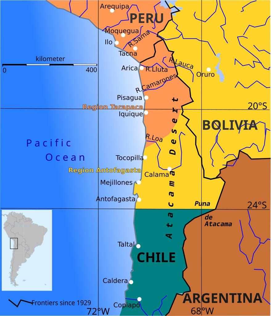
English: Boundary before war (colored areas) and after the War of the Pacific (1879-1883) (black and red lines)
Peruvian territories before the war
Bolivian territories before the war
Chilean territories before the war
Peru-Bolivia Boundary in Atacama Desert according to File:Departamento moquegua 1865.JPG Argentina-Bolivia Boundary in Puna de Atacama and Tarija was contested according to File:MPazSoldan.1888-2xChile.djvu |
||||||
| 日付 | |||||||
| 原典 | 投稿者自身による著作物 | ||||||
| 作者 | Createaccount | ||||||
| 許可 (ファイルの再利用) |
この作品の著作権者である私は、この作品を以下のライセンスで提供します。 このファイルはクリエイティブ・コモンズ 表示-継承 3.0 非移植ライセンスのもとに利用を許諾されています。
あなたは上記のライセンスから、どれか一つ以上を選択できます。 |
||||||
| その他のバージョン | File:Wotp.de.svg |

ファイルの履歴
過去の版のファイルを表示するには、その版の日時をクリックしてください。
| 日付と時刻 | サムネイル | 寸法 | 利用者 | コメント | |
|---|---|---|---|---|---|
| 現在の版 | 2015年4月9日 (木) 13:33 | | 761 × 886 (180キロバイト) | Keysanger (トーク | 投稿記録) | gradient instead of white line at the coast |
| 2015年1月29日 (木) 13:56 |  | 761 × 886 (181キロバイト) | Keysanger (トーク | 投稿記録) | margin cropped. | |
| 2015年1月29日 (木) 13:43 |  | 760 × 887 (182キロバイト) | Keysanger (トーク | 投稿記録) | Back to version with frontiers as for 1929 because they are known and accepted. It is almost impossible to draw all frontiers, at every time for every point of view | |
| 2014年11月7日 (金) 13:27 |  | 760 × 887 (172キロバイト) | Keysanger (トーク | 投稿記録) | Argentina+Bolivia colors for disputed zone | |
| 2014年11月4日 (火) 14:14 |  | 760 × 887 (172キロバイト) | Keysanger (トーク | 投稿記録) | Puna de Atacama was a disputed zone and also Tarija. | |
| 2013年2月12日 (火) 17:29 |  | 760 × 887 (170キロバイト) | Citypeek (トーク | 投稿記録) | removal border and removal legenda (to be added on the page itself) | |
| 2009年10月5日 (月) 19:47 |  | 804 × 1,026 (230キロバイト) | Keysanger (トーク | 投稿記録) | Now Puna de Atacam reaches ca. 26°S | |
| 2009年10月4日 (日) 12:10 |  | 804 × 1,026 (232キロバイト) | Keysanger (トーク | 投稿記録) | Text "Boundary after war" changed to "Chilean boundary after war" | |
| 2009年9月23日 (水) 18:01 |  | 804 × 1,026 (232キロバイト) | Keysanger (トーク | 投稿記録) | Title wasn't necessary, Margin was too big | |
| 2009年7月1日 (水) 23:46 |  | 744 × 1,052 (225キロバイト) | Keysanger (トーク | 投稿記録) | coordinates a white difuse coast line in background |
このファイルは上書きできません。
ファイルの使用状況
以下の 3 ページがこのファイルを使用しています:
グローバルなファイル使用状況
以下に挙げる他のウィキがこの画像を使っています:
- ar.wikipedia.org での使用状況
- ast.wikipedia.org での使用状況
- az.wikipedia.org での使用状況
- ba.wikipedia.org での使用状況
- bg.wikipedia.org での使用状況
- br.wikipedia.org での使用状況
- ca.wikipedia.org での使用状況
- cs.wikipedia.org での使用状況
- da.wikipedia.org での使用状況
- en.wikipedia.org での使用状況
- es.wikipedia.org での使用状況
- fi.wikipedia.org での使用状況
- fr.wiktionary.org での使用状況
- hr.wikipedia.org での使用状況
- hy.wikipedia.org での使用状況
- io.wikipedia.org での使用状況
- ja.wikipedia.org での使用状況
- mk.wikipedia.org での使用状況
- no.wikipedia.org での使用状況
- pt.wikipedia.org での使用状況
- sr.wikipedia.org での使用状況
- sv.wikipedia.org での使用状況
- zh.wikipedia.org での使用状況