File:Map of the War of the Pacific.en.svg
跳至導覽
跳至搜尋

此 SVG 檔案的 PNG 預覽的大小:515 × 600 像素。 其他解析度:206 × 240 像素 | 412 × 480 像素 | 660 × 768 像素 | 879 × 1,024 像素 | 1,759 × 2,048 像素 | 761 × 886 像素。
原始檔案 (SVG 檔案,表面大小:761 × 886 像素,檔案大小:180 KB)
說明
說明
添加單行說明來描述出檔案所代表的內容
摘要
[編輯]| 描述 |
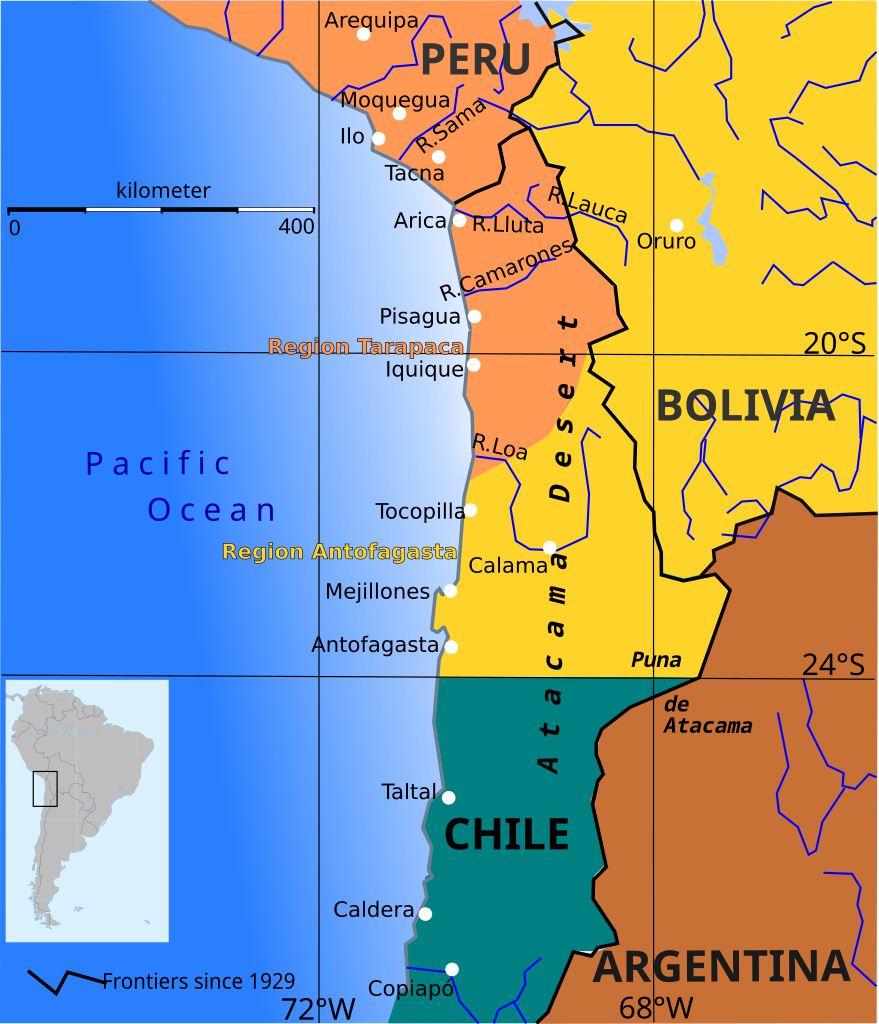
English: Boundary before war (colored areas) and after the War of the Pacific (1879-1883) (black and red lines)
Peruvian territories before the war
Bolivian territories before the war
Chilean territories before the war
Peru-Bolivia Boundary in Atacama Desert according to File:Departamento moquegua 1865.JPG Argentina-Bolivia Boundary in Puna de Atacama and Tarija was contested according to File:MPazSoldan.1888-2xChile.djvu |
||||||
| 日期 | |||||||
| 來源 | 自己的作品 | ||||||
| 作者 | Createaccount | ||||||
| 授權許可 (重用此檔案) |
我,本作品的著作權持有者,決定用以下授權條款發佈本作品: 此檔案採用共享創意 姓名標示-相同方式分享 3.0 未在地化版本授權條款。
您可以選擇您需要的授權條款。 |
||||||
| 其他版本 | File:Wotp.de.svg |

檔案歷史
點選日期/時間以檢視該時間的檔案版本。
| 日期/時間 | 縮圖 | 尺寸 | 用戶 | 備註 | |
|---|---|---|---|---|---|
| 目前 | 2015年4月9日 (四) 13:33 | | 761 × 886(180 KB) | Keysanger(對話 | 貢獻) | gradient instead of white line at the coast |
| 2015年1月29日 (四) 13:56 |  | 761 × 886(181 KB) | Keysanger(對話 | 貢獻) | margin cropped. | |
| 2015年1月29日 (四) 13:43 |  | 760 × 887(182 KB) | Keysanger(對話 | 貢獻) | Back to version with frontiers as for 1929 because they are known and accepted. It is almost impossible to draw all frontiers, at every time for every point of view | |
| 2014年11月7日 (五) 13:27 |  | 760 × 887(172 KB) | Keysanger(對話 | 貢獻) | Argentina+Bolivia colors for disputed zone | |
| 2014年11月4日 (二) 14:14 |  | 760 × 887(172 KB) | Keysanger(對話 | 貢獻) | Puna de Atacama was a disputed zone and also Tarija. | |
| 2013年2月12日 (二) 17:29 |  | 760 × 887(170 KB) | Citypeek(對話 | 貢獻) | removal border and removal legenda (to be added on the page itself) | |
| 2009年10月5日 (一) 19:47 |  | 804 × 1,026(230 KB) | Keysanger(對話 | 貢獻) | Now Puna de Atacam reaches ca. 26°S | |
| 2009年10月4日 (日) 12:10 |  | 804 × 1,026(232 KB) | Keysanger(對話 | 貢獻) | Text "Boundary after war" changed to "Chilean boundary after war" | |
| 2009年9月23日 (三) 18:01 |  | 804 × 1,026(232 KB) | Keysanger(對話 | 貢獻) | Title wasn't necessary, Margin was too big | |
| 2009年7月1日 (三) 23:46 |  | 744 × 1,052(225 KB) | Keysanger(對話 | 貢獻) | coordinates a white difuse coast line in background |
無法覆蓋此檔案。
檔案用途
下列3個頁面有用到此檔案:
全域檔案使用狀況
以下其他 wiki 使用了這個檔案:
- ar.wikipedia.org 的使用狀況
- ast.wikipedia.org 的使用狀況
- az.wikipedia.org 的使用狀況
- ba.wikipedia.org 的使用狀況
- bg.wikipedia.org 的使用狀況
- br.wikipedia.org 的使用狀況
- ca.wikipedia.org 的使用狀況
- cs.wikipedia.org 的使用狀況
- da.wikipedia.org 的使用狀況
- en.wikipedia.org 的使用狀況
- es.wikipedia.org 的使用狀況
- fi.wikipedia.org 的使用狀況
- fr.wiktionary.org 的使用狀況
- hr.wikipedia.org 的使用狀況
- hy.wikipedia.org 的使用狀況
- io.wikipedia.org 的使用狀況
- ja.wikipedia.org 的使用狀況
- mk.wikipedia.org 的使用狀況
- no.wikipedia.org 的使用狀況
- pt.wikipedia.org 的使用狀況
- sr.wikipedia.org 的使用狀況
- sv.wikipedia.org 的使用狀況
- zh.wikipedia.org 的使用狀況