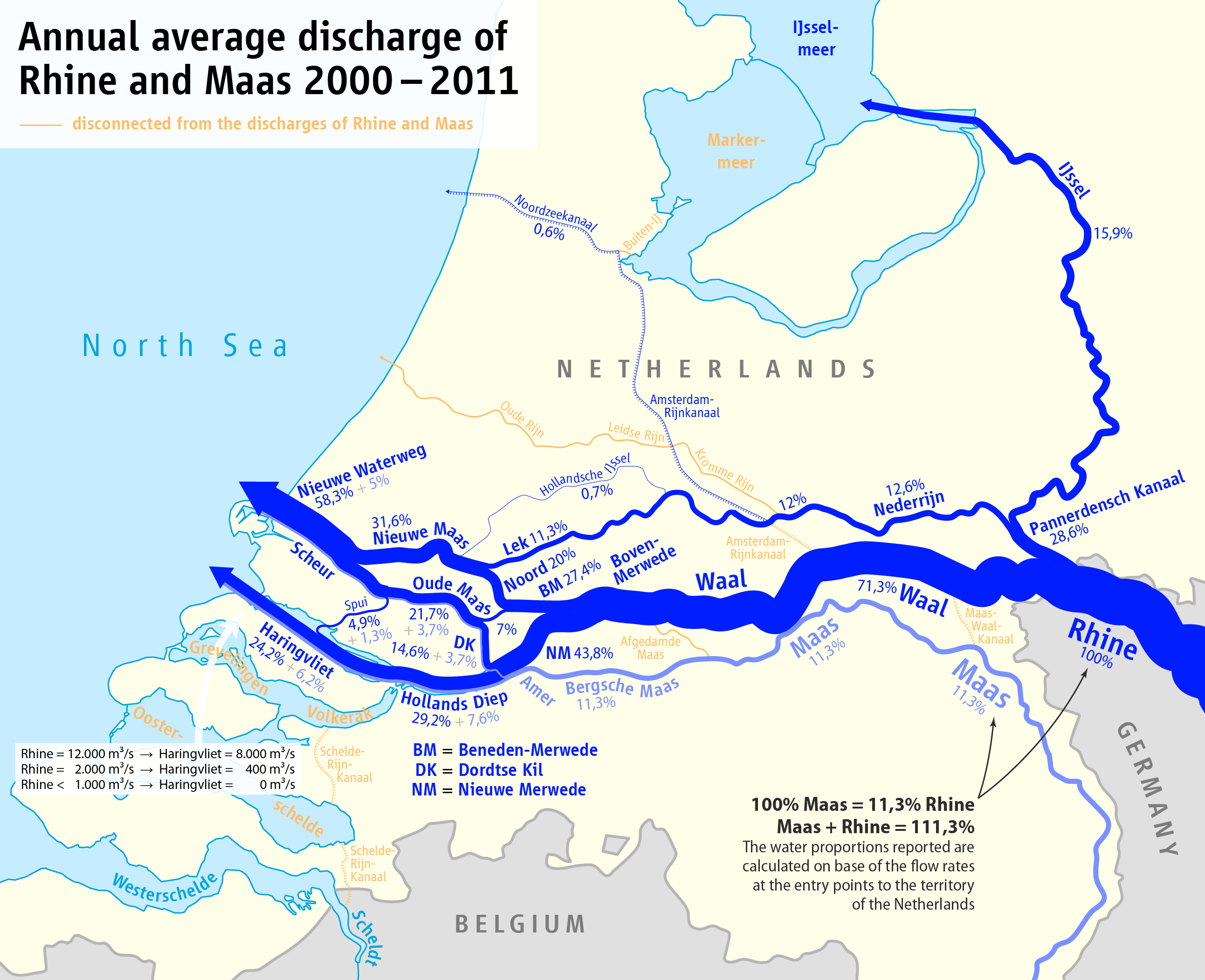
File:Map of the annual average discharge of Rhine and Maas 2000-2011 (EN).png
跳至導覽
跳至搜尋
預覽大小:737 × 600 像素。 其他解析度:295 × 240 像素 | 590 × 480 像素 | 944 × 768 像素 | 1,259 × 1,024 像素 | 2,518 × 2,048 像素 | 2,585 × 2,103 像素。
原始檔案 (2,585 × 2,103 像素,檔案大小:348 KB,MIME 類型:image/png)
說明
說明
添加單行說明來描述出檔案所代表的內容
| 描述 |
|
| 日期 | see file history |
| 來源 |
自己的作品, using
|
| 作者 | Maximilian Dörrbecker (Chumwa) |
| 授權許可 (重用此檔案) |
我,本作品的著作權持有者,決定用以下授權條款發佈本作品: 此檔案採用創用CC 姓名標示-相同方式分享 2.5 通用版授權條款。
Sie dürfen das Bild zu den folgenden Bedingungen nutzen:
|
| 其他版本 |
|
.png)
.png)
.png)
.png)


|
本圖片是以PNG、GIF或JPEG格式上傳。然而,其中包含的資料或訊息,應該重新建立成可縮放向量圖形(SVG)檔案,以更有效率或更準確的方式儲存。如有可能,請上傳本圖片的SVG格式版本。在上傳之後,請修改維基各姊妹計畫中所有使用舊版圖片的條目(列在圖像連結章節中),替換為新版圖片,並在舊圖片的描述頁中加入{{Vector version available|新圖片名稱.svg}}模板,同時移除本模板。
|
檔案歷史
點選日期/時間以檢視該時間的檔案版本。
| 日期/時間 | 縮圖 | 尺寸 | 用戶 | 備註 | |
|---|---|---|---|---|---|
| 目前 | 2016年10月6日 (四) 23:08 | | 2,585 × 2,103(348 KB) | Cmdrjameson(對話 | 貢獻) | Compressed with pngout. Reduced by 225kB (39% decrease). |
| 2016年3月5日 (六) 19:42 |  | 2,585 × 2,103(574 KB) | Chumwa(對話 | 貢獻) | ||
| 2016年2月3日 (三) 19:03 |  | 3,589 × 2,919(840 KB) | Chumwa(對話 | 貢獻) | ||
| 2016年2月3日 (三) 06:38 |  | 3,589 × 2,919(840 KB) | Chumwa(對話 | 貢獻) | {{Information |Description= *{{de|Karte der Aufteilung der Abflüsse im Rhein-Maas-Delta 2000-2011}} *{{en|Map of the partition of Rhine and Meuse water among the various branches of their delta 2000-2011}} |Source={{Own}}, using * [[:File:Netherlands... |
無法覆蓋此檔案。
檔案用途
下列11個頁面有用到此檔案:
- Oppervlaktewater in Nederland
- User:Chumwa/Gallery
- User:Chumwa/OgreBot/Potential transport maps/2016 October 1-10
- User:Chumwa/OgreBot/Transport Maps/2016 March 1-10
- User:Chumwa/OgreBot/Transport Maps/2016 October 1-10
- User:Chumwa/OgreBot/Travel and communication maps/2016 March 1-10
- User:Chumwa/OgreBot/Travel and communication maps/2016 October 1-10
- File:Map of the annual average discharge of Rhine and Maas 2000-2011 (DE).png
- File:Map of the annual average discharge of Rhine and Maas 2000-2011 (EN).png
- File:Map of the annual average discharge of Rhine and Maas 2000-2011 (FR).png
- File:Map of the annual average discharge of Rhine and Maas 2000-2011 (NL).png
全域檔案使用狀況
以下其他 wiki 使用了這個檔案:
- bg.wikipedia.org 的使用狀況
- da.wikipedia.org 的使用狀況
- de.wikipedia.org 的使用狀況
- en.wikipedia.org 的使用狀況
- en.wiktionary.org 的使用狀況
- es.wikipedia.org 的使用狀況
- eu.wikipedia.org 的使用狀況
- fr.wikipedia.org 的使用狀況
- id.wikipedia.org 的使用狀況
- it.wikipedia.org 的使用狀況
- mt.wikipedia.org 的使用狀況
- ru.wikipedia.org 的使用狀況
- sl.wikipedia.org 的使用狀況
- sv.wikipedia.org 的使用狀況
- tr.wikipedia.org 的使用狀況
- uk.wikipedia.org 的使用狀況
- vep.wikipedia.org 的使用狀況
- zh.wikipedia.org 的使用狀況
.png&oldid=776152986)