File:Map of the partition of the Kingdom of Poland and the Grand Duchy of Lithuania from 1799.jpg
跳转到导航
跳转到搜索

本预览的尺寸:669 × 600像素。 其他分辨率:268 × 240像素 | 535 × 480像素 | 856 × 768像素 | 1,142 × 1,024像素 | 2,284 × 2,048像素 | 6,330 × 5,677像素。
原始文件 (6,330 × 5,677像素,文件大小:6.83 MB,MIME类型:image/jpeg)
说明
说明
添加一行文字以描述该文件所表现的内容
摘要
[编辑]
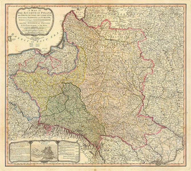
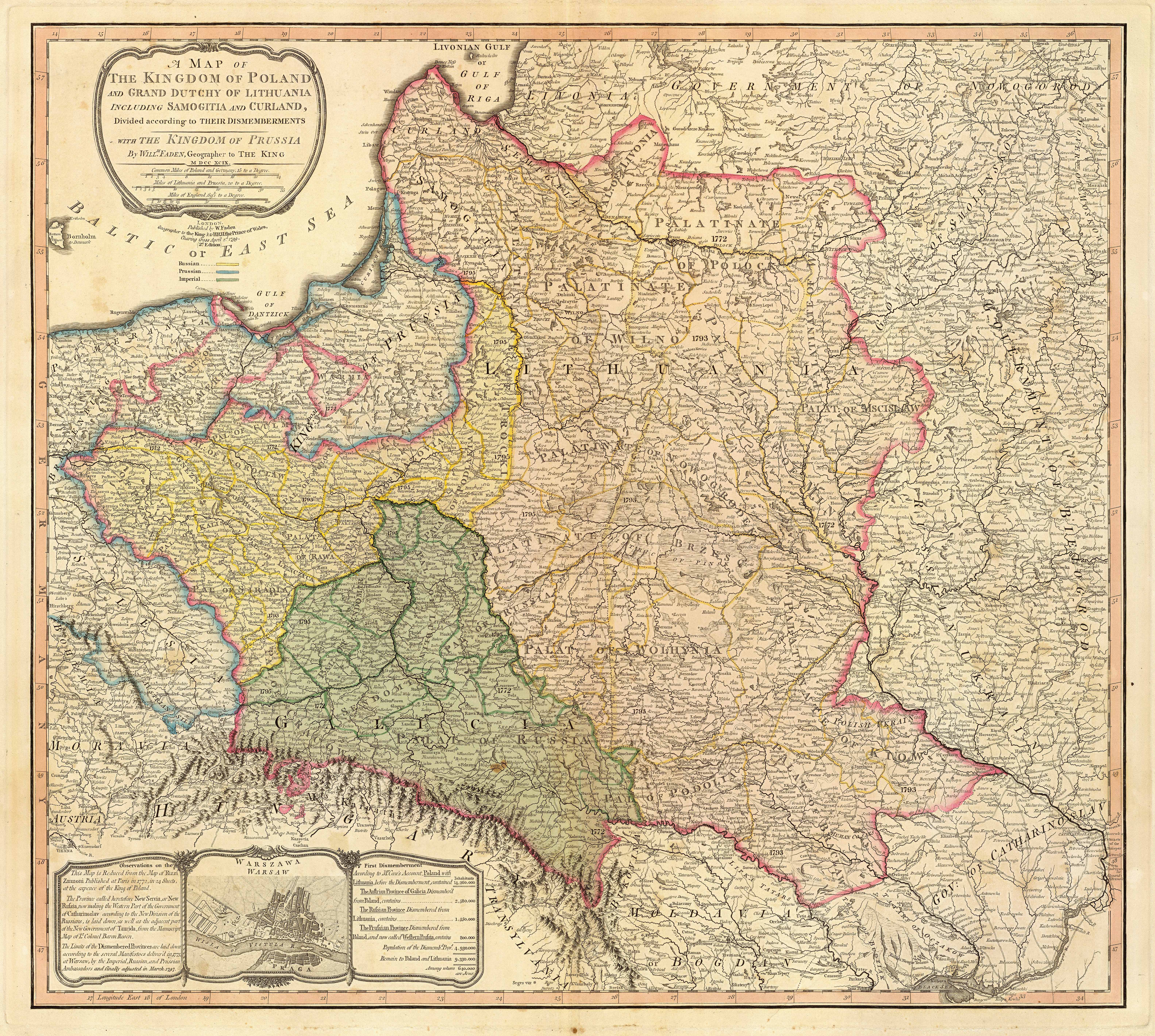
| 描述 | Title: "A map of the Kingdom of Poland and the Grand Duchy of Lithuania including Samogitia and Curland divided according to their dismemberments with the Kingdom of Prussia". A map from 1799 showing how the Polish-Lithuanian Commonwealth was partitioned in 1765-1795 between Prussia, Austria, and Russia. This is an extremely detailed map which lists all the cities and small towns and labels the regions according to their English names. The boundaries former Polish-Lithuanian Commonwealth colored light red. The areas taken by Prussia are colored yellow, those taken by Austria colored green, and those taken by Russia are colored beige. Prussia itself is bordered in blue. Eastern Pomerania and Warmia are shown as part of Prussia but bordered in red as well. |
| 日期 | |
| 来源 | http://www.belarusguide.com/images/maps/Kokosha/POlonia&Lituania-1799.jpg |
| 作者 |
许可协议
[编辑]
|
本作品在其来源国以及其他著作权期限是作者逝世后100年或以下的国家和地区属于公有领域。 | |
| 本文件已被确认为免除已知的著作权法限制(包括所有相关权利)。 | |
文件历史
点击某个日期/时间查看对应时刻的文件。
| 日期/时间 | 缩略图 | 大小 | 用户 | 备注 | |
|---|---|---|---|---|---|
| 当前 | 2007年9月23日 (日) 05:04 | | 6,330 × 5,677(6.83 MB) | Archaeogenetics(留言 | 贡献) | {{Information |Description=Title: "A map of the Kingdom of Poland and the Grand Duchy of Lithuania including Samogitia and Curland divided according to their dismemberments with the Kingdom of Prussia". A map from 1799 showing how the Polish-Lithuanian Co |
您不可以覆盖此文件。
文件用途
没有页面使用本文件。
全域文件用途
以下其他wiki使用此文件:
- en.wikipedia.org上的用途
- et.wikipedia.org上的用途
- lt.wikipedia.org上的用途
- lt.wikibooks.org上的用途
- pnb.wikipedia.org上的用途
- th.wikipedia.org上的用途
- uk.wikipedia.org上的用途
- ur.wikipedia.org上的用途
- zh.wikipedia.org上的用途
元数据
分类:
- History maps of Samogitia
- Old maps of the Polish-Lithuanian Commonwealth
- Old maps of partitioned Poland
- Old maps of Latvia
- 18th-century maps of Estonia
- 18th-century maps of Latvia
- Maps by William Faden
- 1799 maps
- Volhynian Voivodeship (1569–1795)
- Maps of Ruthenian Voivodeship
- Belz Voivodeship
- Podolian Voivodeship
- Maps of Kiev Voivodeship (1471-1793)
- Old maps of Galicia (Central Europe)
- 1799 maps of Lithuania