File:Map of the southern Balkans, 1410-es.svg
Aller à la navigation
Aller à la recherche

Taille de cet aperçu PNG pour ce fichier SVG : 679 × 600 pixels. Autres résolutions : 272 × 240 pixels | 543 × 480 pixels | 869 × 768 pixels | 1 159 × 1 024 pixels | 2 318 × 2 048 pixels | 2 217 × 1 959 pixels.
Fichier d’origine (Fichier SVG, nominalement de 2 217 × 1 959 pixels, taille : 2,76 Mio)
Légendes
Légendes
Ajoutez en une ligne la description de ce que représente ce fichier
Description
[modifier]
| Description |
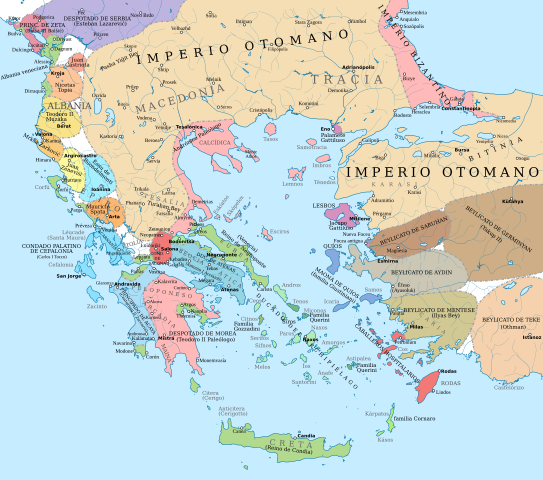
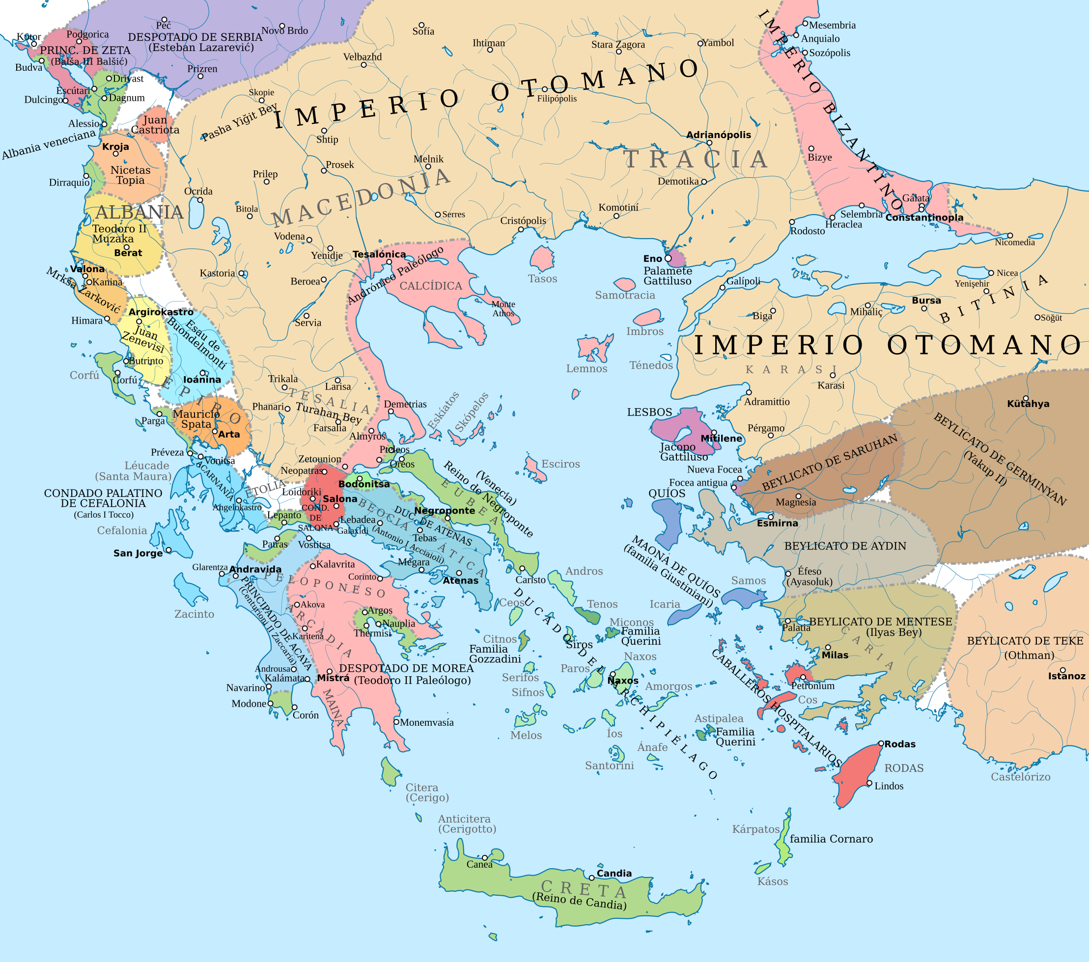
English: Political map of the southern Balkans and western Anatolia in 1410. Disclaimer: The borders shown are often uncertain and conjectural; an effort has been made to be as accurate as possible and follow the relevant scholarship, but errors or omissions may still be present. Any help in correcting and/or improving this work would be greatly appreciated.
Sources: Basic map sources:
Southern Greece and Latin states in the Aegean and the Balkans:
Epirus, Albania, Montenegro:
Northern Greece:
Boundaries of the Byzantine Empire:
Ottoman Empire and Anatolian beyliks:
|
| Source |
Ce fichier est dérivé de : Map of the southern Balkans, 1410.svg |
| Auteur | Constantine Plakidas |
Conditions d’utilisation
[modifier]
Ce fichier est sous la licence Creative Commons Attribution – Partage dans les Mêmes Conditions 4.0 International.
- Vous êtes libre :
- de partager – de copier, distribuer et transmettre cette œuvre
- d’adapter – de modifier cette œuvre
- Sous les conditions suivantes :
- paternité – Vous devez donner les informations appropriées concernant l'auteur, fournir un lien vers la licence et indiquer si des modifications ont été faites. Vous pouvez faire cela par tout moyen raisonnable, mais en aucune façon suggérant que l’auteur vous soutient ou approuve l’utilisation que vous en faites.
- partage à l’identique – Si vous modifiez, transformez, ou vous basez sur cette œuvre, vous devez distribuer votre contribution sous la même licence ou une licence compatible avec celle de l’original.
Historique du fichier
Cliquer sur une date et heure pour voir le fichier tel qu'il était à ce moment-là.
| Date et heure | Vignette | Dimensions | Utilisateur | Commentaire | |
|---|---|---|---|---|---|
| actuel | 23 août 2021 à 06:43 | | 2 217 × 1 959 (2,76 Mio) | Rowanwindwhistler (d | contributions) | Background updated from source map |
| 16 juillet 2019 à 16:41 |  | 2 217 × 1 959 (2,76 Mio) | Rowanwindwhistler (d | contributions) | Uploading a file from a free published source using File Upload Wizard |
Vous ne pouvez pas remplacer ce fichier.
Utilisations locales du fichier
La page suivante utilise ce fichier :
Utilisations du fichier sur d’autres wikis
Les autres wikis suivants utilisent ce fichier :
- Utilisation sur es.wikipedia.org
- Utilisation sur fr.wikipedia.org
Métadonnées
Catégories :
- Maps showing 15th-century history
- Maps of the history of the Ottoman Empire in the 1410s
- Maps of the Byzantine empire in the 15th century
- Maps of the history of the medieval Balkans
- 1410
- Maps of the Duchy of Athens
- Maps of the Principality of Achaea
- Maps of the Anatolian beyliks
- Maps of the Duchy of the Archipelago
- Stato da Màr
- Spanish-language SVG maps showing history