File:Map of the southern Balkans, 1410.svg
Aller à la navigation
Aller à la recherche

Taille de cet aperçu PNG pour ce fichier SVG : 679 × 600 pixels. Autres résolutions : 272 × 240 pixels | 543 × 480 pixels | 869 × 768 pixels | 1 159 × 1 024 pixels | 2 318 × 2 048 pixels | 2 217 × 1 959 pixels.
Fichier d’origine (Fichier SVG, nominalement de 2 217 × 1 959 pixels, taille : 2,56 Mio)
Légendes
Légendes
Ajoutez en une ligne la description de ce que représente ce fichier
Description
[modifier]
| Description |
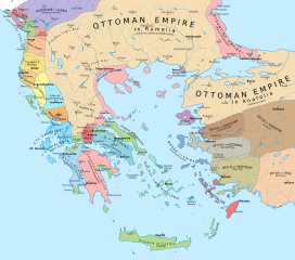
English: Political map of the southern Balkans and western Anatolia in 1410. Disclaimer: The borders shown are often uncertain and conjectural; an effort has been made to be as accurate as possible and follow the relevant scholarship, but errors or omissions may still be present. Any help in correcting and/or improving this work would be greatly appreciated. |
| Date | |
| Source |
Travail personnel avec:
|
| Auteur | Constantine Plakidas |
Conditions d’utilisation
[modifier]
Moi, en tant que détenteur des droits d’auteur sur cette œuvre, je la publie sous la licence suivante :
Ce fichier est sous la licence Creative Commons Attribution – Partage dans les Mêmes Conditions 4.0 International.
- Vous êtes libre :
- de partager – de copier, distribuer et transmettre cette œuvre
- d’adapter – de modifier cette œuvre
- Sous les conditions suivantes :
- paternité – Vous devez donner les informations appropriées concernant l'auteur, fournir un lien vers la licence et indiquer si des modifications ont été faites. Vous pouvez faire cela par tout moyen raisonnable, mais en aucune façon suggérant que l’auteur vous soutient ou approuve l’utilisation que vous en faites.
- partage à l’identique – Si vous modifiez, transformez, ou vous basez sur cette œuvre, vous devez distribuer votre contribution sous la même licence ou une licence compatible avec celle de l’original.
Historique du fichier
Cliquer sur une date et heure pour voir le fichier tel qu'il était à ce moment-là.
| Date et heure | Vignette | Dimensions | Utilisateur | Commentaire | |
|---|---|---|---|---|---|
| actuel | 2 avril 2023 à 10:16 | | 2 217 × 1 959 (2,56 Mio) | Cplakidas (d | contributions) | cleanup of whitespaces, white background instead of transparent |
| 19 novembre 2019 à 16:24 |  | 2 217 × 1 959 (2,58 Mio) | Cplakidas (d | contributions) | forgot some things.. | |
| 19 novembre 2019 à 16:17 |  | 2 217 × 1 959 (1,29 Mio) | Cplakidas (d | contributions) | modified Byzantine borders in Bithynia to cover northern part of the Gulf of Nicomedia/Izmit (cf. en:Treaty of Gallipoli) | |
| 23 mars 2018 à 14:46 |  | 2 217 × 1 959 (3,42 Mio) | Cplakidas (d | contributions) | city names to paths | |
| 23 mars 2018 à 13:46 |  | 2 217 × 1 959 (2,39 Mio) | Cplakidas (d | contributions) | User created page with UploadWizard |
Vous ne pouvez pas remplacer ce fichier.
Utilisations locales du fichier
Les 5 pages suivantes utilisent ce fichier :
.jpg)
Utilisations du fichier sur d’autres wikis
Les autres wikis suivants utilisent ce fichier :
- Utilisation sur ar.wikipedia.org
- Utilisation sur azb.wikipedia.org
- Utilisation sur bg.wikipedia.org
- Utilisation sur bs.wikipedia.org
- Utilisation sur de.wikipedia.org
- Utilisation sur en.wikipedia.org
- Epirus
- Manuel II Palaiologos
- Principality of Achaea
- Giorgio de' Buondelmonti
- Siege of Thessalonica (1422–1430)
- Maurice Spata
- Ottoman–Venetian peace treaty (1419)
- Süleyman Çelebi
- Junayd of Aydın
- Battle of Gallipoli (1416)
- Treaty of Gallipoli
- Treaty of Selymbria
- Crusades of the 15th century
- Ottoman conquest of the Morea
- Utilisation sur fr.wikipedia.org
- Utilisation sur he.wikipedia.org
- Utilisation sur hu.wikipedia.org
- Utilisation sur hy.wikipedia.org
- Utilisation sur it.wikipedia.org
- Utilisation sur ka.wikipedia.org
- Utilisation sur mk.wikipedia.org
- Utilisation sur pl.wikipedia.org
- Utilisation sur pt.wikipedia.org
- Utilisation sur ru.wikipedia.org
- Utilisation sur sl.wikipedia.org
Voir davantage sur l’utilisation globale de ce fichier.
Métadonnées
Catégories :
- Maps showing 15th-century history
- Maps of the history of the Ottoman Empire in the 1410s
- Maps of the Byzantine empire in the 15th century
- Maps of the history of the medieval Balkans
- 1410
- Maps of the Duchy of Athens
- Maps of the Principality of Achaea
- Maps of Anatolian beyliks
- Maps of the Duchy of the Archipelago
- Stato da Màr