File:Map of the southern Balkans, 1410.svg
跳至導覽
跳至搜尋

此 SVG 檔案的 PNG 預覽的大小:679 × 600 像素。 其他解析度:272 × 240 像素 | 543 × 480 像素 | 869 × 768 像素 | 1,159 × 1,024 像素 | 2,318 × 2,048 像素 | 2,217 × 1,959 像素。
原始檔案 (SVG 檔案,表面大小:2,217 × 1,959 像素,檔案大小:2.56 MB)
說明
說明
添加單行說明來描述出檔案所代表的內容
摘要
[編輯]
| 描述 |
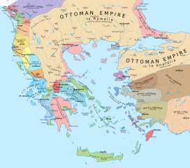
English: Political map of the southern Balkans and western Anatolia in 1410. Disclaimer: The borders shown are often uncertain and conjectural; an effort has been made to be as accurate as possible and follow the relevant scholarship, but errors or omissions may still be present. Any help in correcting and/or improving this work would be greatly appreciated. |
| 日期 | |
| 來源 |
個人作品,使用:
|
| 作者 | Constantine Plakidas |
授權條款
[編輯]
我,本作品的著作權持有者,決定用以下授權條款發佈本作品:
此檔案採用共享創意 姓名標示-相同方式分享 4.0 國際授權條款。
- 您可以自由:
- 分享 – 複製、發佈和傳播本作品
- 重新修改 – 創作演繹作品
- 惟需遵照下列條件:
- 姓名標示 – 您必須指名出正確的製作者,和提供授權條款的連結,以及表示是否有對內容上做出變更。您可以用任何合理的方式來行動,但不得以任何方式表明授權條款是對您許可或是由您所使用。
- 相同方式分享 – 如果您利用本素材進行再混合、轉換或創作,您必須基於如同原先的相同或兼容的條款,來分布您的貢獻成品。
檔案歷史
點選日期/時間以檢視該時間的檔案版本。
| 日期/時間 | 縮圖 | 尺寸 | 用戶 | 備註 | |
|---|---|---|---|---|---|
| 目前 | 2023年4月2日 (日) 10:16 | | 2,217 × 1,959(2.56 MB) | Cplakidas(對話 | 貢獻) | cleanup of whitespaces, white background instead of transparent |
| 2019年11月19日 (二) 16:24 |  | 2,217 × 1,959(2.58 MB) | Cplakidas(對話 | 貢獻) | forgot some things.. | |
| 2019年11月19日 (二) 16:17 |  | 2,217 × 1,959(1.29 MB) | Cplakidas(對話 | 貢獻) | modified Byzantine borders in Bithynia to cover northern part of the Gulf of Nicomedia/Izmit (cf. en:Treaty of Gallipoli) | |
| 2018年3月23日 (五) 14:46 |  | 2,217 × 1,959(3.42 MB) | Cplakidas(對話 | 貢獻) | city names to paths | |
| 2018年3月23日 (五) 13:46 |  | 2,217 × 1,959(2.39 MB) | Cplakidas(對話 | 貢獻) | User created page with UploadWizard |
無法覆蓋此檔案。
檔案用途
下列5個頁面有用到此檔案:
.jpg)
全域檔案使用狀況
以下其他 wiki 使用了這個檔案:
- ar.wikipedia.org 的使用狀況
- azb.wikipedia.org 的使用狀況
- bg.wikipedia.org 的使用狀況
- bs.wikipedia.org 的使用狀況
- de.wikipedia.org 的使用狀況
- en.wikipedia.org 的使用狀況
- Epirus
- Manuel II Palaiologos
- Principality of Achaea
- Giorgio de' Buondelmonti
- Siege of Thessalonica (1422–1430)
- Maurice Spata
- Ottoman–Venetian peace treaty (1419)
- Süleyman Çelebi
- Junayd of Aydın
- Battle of Gallipoli (1416)
- Treaty of Gallipoli
- Treaty of Selymbria
- Crusades of the 15th century
- Ottoman conquest of the Morea
- User:Falcaorib/Medieval Empires (1300-1500 AD)
- User:Falcaorib/Turkey and Ottoman Empire
- fr.wikipedia.org 的使用狀況
- he.wikipedia.org 的使用狀況
- hu.wikipedia.org 的使用狀況
- hy.wikipedia.org 的使用狀況
- it.wikipedia.org 的使用狀況
- ka.wikipedia.org 的使用狀況
- mk.wikipedia.org 的使用狀況
- pl.wikipedia.org 的使用狀況
- pt.wikipedia.org 的使用狀況
- ru.wikipedia.org 的使用狀況
檢視此檔案的更多全域使用狀況。
詮釋資料
分類:
- Maps showing 15th-century history
- Maps of the history of the Ottoman Empire in the 1410s
- Maps of the Byzantine empire in the 15th century
- Maps of the history of the medieval Balkans
- 1410
- Maps of the Duchy of Athens
- Maps of the Principality of Achaea
- Maps of the Anatolian beyliks
- Maps of the Duchy of the Archipelago
- Stato da Màr