File:Map of traditional provinces of Libye-en.svg
Aller à la navigation
Aller à la recherche

Taille de cet aperçu PNG pour ce fichier SVG : 625 × 599 pixels. Autres résolutions : 250 × 240 pixels | 501 × 480 pixels | 801 × 768 pixels | 1 068 × 1 024 pixels | 2 136 × 2 048 pixels | 969 × 929 pixels.
Fichier d’origine (Fichier SVG, nominalement de 969 × 929 pixels, taille : 106 kio)
Légendes
Légendes
Ajoutez en une ligne la description de ce que représente ce fichier
| Description |
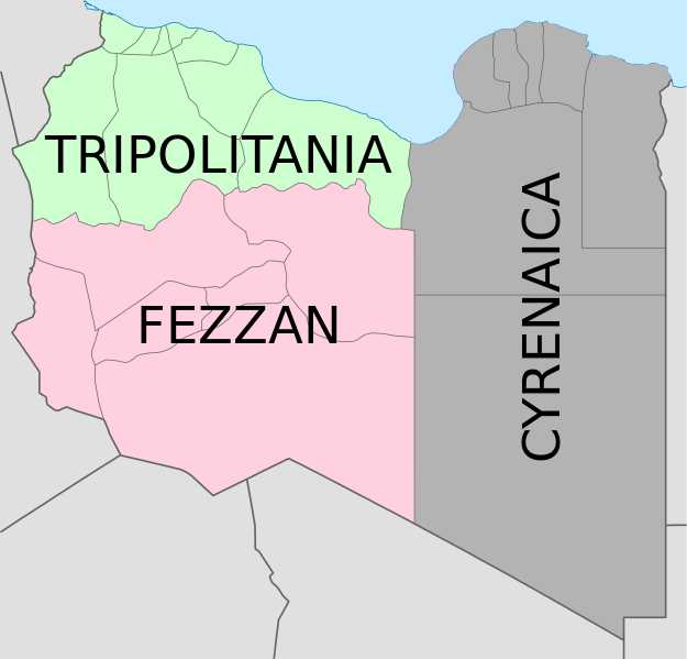
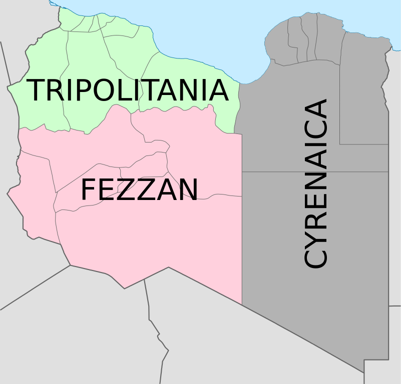
Deutsch: Historische provinzen (Governorates) Libyens English: Map of the three Governorates of Libya based on the borders of today's governorates. After independence in 1951, until 1963, Libya was divided into three governorates (muhafazat): Cyrenaica, Tripolitania, and Fezzan. The eastern border between Tripolitania and Fezzan was before 1969 slightly different: the northern part of Al Jufrah District in today's Fezzan belonged to Tripolitania, see here File:Ottoman Provinces Of Present day Libyapng.png. Español: Mapa de las tres governorates de Libia: Tripolitania, Fezzan, y Cirenaica. Français : Carte en anglais des trois provinces historiques (gouvernorats) de la Libye contemporaine. |
| Date | (UTC) |
| Source | |
| Auteur |
|
| Autres versions |
|


| Cette image a été retouchée, ce qui signifie qu'elle a été modifiée par ordinateur et est différente de l'image d'origine. Liste des modifications : translation in english. L'image d'origine se trouve ici : Map of traditionnal provinces of Libye fr.svg:
|
Moi, en tant que détenteur des droits d’auteur sur cette œuvre, je la publie sous les licences suivantes :
Ce fichier est disponible selon les termes de la licence Creative Commons Attribution 3.0 Non transposée.
- Vous êtes libre :
- de partager – de copier, distribuer et transmettre cette œuvre
- d’adapter – de modifier cette œuvre
- Sous les conditions suivantes :
- paternité – Vous devez donner les informations appropriées concernant l'auteur, fournir un lien vers la licence et indiquer si des modifications ont été faites. Vous pouvez faire cela par tout moyen raisonnable, mais en aucune façon suggérant que l’auteur vous soutient ou approuve l’utilisation que vous en faites.

|
Vous avez la permission de copier, distribuer et modifier ce document selon les termes de la GNU Free Documentation License version 1.2 ou toute version ultérieure publiée par la Free Software Foundation, sans sections inaltérables, sans texte de première page de couverture et sans texte de dernière page de couverture. Un exemplaire de la licence est inclus dans la section intitulée GNU Free Documentation License. |
Vous pouvez choisir l’une de ces licences.
Journal des téléversements d’origine
[modifier]
This image is a derivative work of the following images:
- File:Map_of_traditionnal_provinces_of_Libye_fr.svg licensed with Cc-by-3.0, GFDL
- 2011-02-25T14:34:29Z Пакко 969x929 (120204 Bytes) upg
- 2011-02-25T13:46:48Z Xfigpower 970x931 (162661 Bytes) {{Information |Description={{fr|les trois provinces mappées sur la arte actuelle de la LibyeLes couleurs sont celles symbolisées par le drapeau}} |Source=*[[:File:Libya_location_map.svg|]] |Date=2011-02-25 13:29 (UTC) |Auth
Téléversé avec derivativeFX
Historique du fichier
Cliquer sur une date et heure pour voir le fichier tel qu'il était à ce moment-là.
| Date et heure | Vignette | Dimensions | Utilisateur | Commentaire | |
|---|---|---|---|---|---|
| actuel | 24 août 2021 à 08:36 | | 969 × 929 (106 kio) | أحمد الغرباوي (d | contributions) | File uploaded using svgtranslate tool (https://svgtranslate.toolforge.org/). Added translation for ar. |
| 6 décembre 2020 à 15:44 |  | 969 × 929 (104 kio) | ידידיה צ' צבאן (d | contributions) | File uploaded using svgtranslate tool (https://svgtranslate.toolforge.org/). Added translation for he. | |
| 12 octobre 2011 à 03:46 |  | 969 × 929 (104 kio) | Spesh531 (d | contributions) | updated to current internal boundaries | |
| 30 août 2011 à 12:50 |  | 969 × 929 (147 kio) | Orange Tuesday (d | contributions) | see http://www.crwflags.com/fotw/flags/ly_1951.html for source on traditional colours | |
| 30 août 2011 à 01:40 |  | 969 × 929 (124 kio) | Hellerick (d | contributions) | Found no information on "traditional association" | |
| 13 juin 2011 à 20:24 |  | 969 × 929 (147 kio) | Kmusser (d | contributions) | shift colors to match traditional association | |
| 29 avril 2011 à 11:04 |  | 969 × 929 (125 kio) | Hellerick (d | contributions) | Neutral colors; + foreign nations borders | |
| 16 mars 2011 à 13:02 |  | 969 × 929 (121 kio) | Bourrichon (d | contributions) | typo | |
| 16 mars 2011 à 13:01 |  | 969 × 929 (121 kio) | Bourrichon (d | contributions) | +bug typo | |
| 16 mars 2011 à 12:58 |  | 969 × 929 (112 kio) | Bourrichon (d | contributions) | {{Information |Description={{de|Historische provinzen (Governorates) Libyens}} {{en| Map of the three '''{{w|Governorates of Libya}}'''. After independence in 1951, until 1963, Libya was divided into three governorates (''{{w|muhafazat}}''): '''{{w|Cyrena |
Vous ne pouvez pas remplacer ce fichier.
Utilisations locales du fichier
Les 10 pages suivantes utilisent ce fichier :
- File:Map of traditional provinces of Libye-ar.png
- File:Map of traditional provinces of Libye-ar.svg
- File:Map of traditional provinces of Libye-ka.png
- File:Map of traditional provinces of Libye-no.svg
- File:Map of traditional provinces of Libye-pt.svg
- File:Map of traditionnal provinces of Libye-en.svg (redirection de fichier)
- File:Ottoman Provinces Of Present day Libya.png
- Category:Cyrenaica
- Category:Postage stamps of Cyrenaica
- Category:Stamps of Italian Libya
Utilisations du fichier sur d’autres wikis
Les autres wikis suivants utilisent ce fichier :
- Utilisation sur ar.wikipedia.org
- Utilisation sur ast.wikipedia.org
- Utilisation sur az.wikipedia.org
- Utilisation sur bs.wikipedia.org
- Utilisation sur ca.wikipedia.org
- Utilisation sur cs.wikipedia.org
- Utilisation sur diq.wikipedia.org
- Utilisation sur en.wikipedia.org
- History of Libya
- Libya
- Geography of Libya
- Demographics of Libya
- Politics of Libya
- Economy of Libya
- Mass media in Libya
- Transport in Libya
- Armed Forces of the Libyan Arab Jamahiriya
- Foreign relations of Libya under Muammar Gaddafi
- Fatimid Caliphate
- Idris of Libya
- List of cities in Libya
- Operation Sonnenblume
- Libyan dinar
- List of heads of state of Libya
- Districts of Libya
- Great Man-Made River
- List of colonial governors of Italian Cyrenaica
- List of heads of government of Libya
- Music of Libya
- Elections in Libya
- Karamanli dynasty
- Ahmed Karamanli
- Culture of Libya
- Central Bank of Libya
- Public Scout and Girl Guide Movement
- General People's Congress (Libya)
- Human rights in Libya
- Subdivisions of Libya
- Provinces of Libya
- Islamic Tripolitania and Cyrenaica
- Ottoman Tripolitania
- Italian colonization of Libya
- History of Libya under Muammar Gaddafi
- Chadian–Libyan War
- Ancient Libya
- Template:Libya topics
- Media of Libya
Voir davantage sur l’utilisation globale de ce fichier.