File:Mapa Ciudad de Cordoba 1802.png
Jump to navigation
Jump to search

Size of this preview: 800 × 574 pixels. Other resolutions: 320 × 230 pixels | 640 × 460 pixels | 1,024 × 735 pixels | 1,280 × 919 pixels | 2,560 × 1,838 pixels | 4,846 × 3,480 pixels.
Original file (4,846 × 3,480 pixels, file size: 35.82 MB, MIME type: image/png)
Captions
Captions
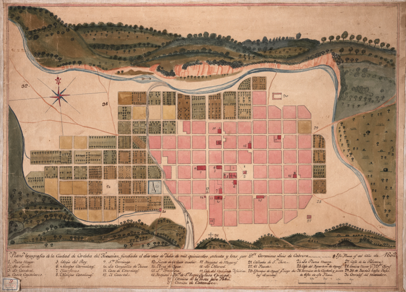
Map of Cordoba City, 1802. Viceroyalty of Río de la Plata.
Summary[edit]
| Description |
English: Topographic map of the city of Cordoba del Tucumán. National Library of Brazil. Español: Plano topográfico de la Ciudad de Cordoba del Tucumán. Biblioteca Nacional de Brasil. |
| Date | |
| Source | http://acervo.bndigital.bn.br/sophia/index.asp?codigo_sophia=882 |
| Author | Unknown author |
Licensing[edit]
|
This work is in the public domain in its country of origin and other countries and areas where the copyright term is the author's life plus 100 years or fewer. This work is in the public domain in the United States because it was published (or registered with the U.S. Copyright Office) before January 1, 1929. | |
| This file has been identified as being free of known restrictions under copyright law, including all related and neighboring rights. | |
File history
Click on a date/time to view the file as it appeared at that time.
| Date/Time | Thumbnail | Dimensions | User | Comment | |
|---|---|---|---|---|---|
| current | 05:50, 1 June 2022 | | 4,846 × 3,480 (35.82 MB) | GM83 (talk | contribs) | Uploaded a work by Unknown from http://acervo.bndigital.bn.br/sophia/index.html with UploadWizard |
You cannot overwrite this file.
File usage on Commons
There are no pages that use this file.
File usage on other wikis
The following other wikis use this file:
- Usage on es.wikipedia.org