File:Mapa Eclipse Solar Total 02.07.2019 - 05.png
Jump to navigation
Jump to search

Size of this preview: 776 × 600 pixels. Other resolutions: 311 × 240 pixels | 621 × 480 pixels | 993 × 768 pixels | 1,252 × 968 pixels.
Original file (1,252 × 968 pixels, file size: 352 KB, MIME type: image/png)
Captions
Captions
Add a one-line explanation of what this file represents
Summary
[edit]| Description |
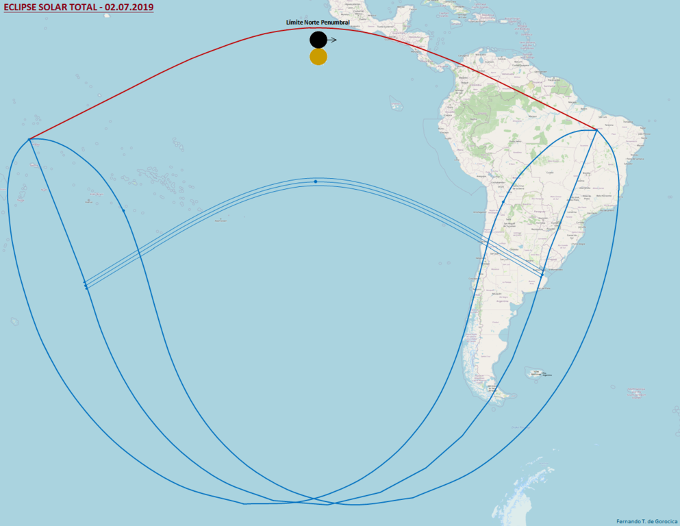
Español: Eclipse Solar Total del 02.07.2019. Verː Eclipse Solar Total del 02.07.2019 en toda la Argentina y en la Provincia de Buenos Aires. |
||||||||||||||||||||
| Date | |||||||||||||||||||||
| Source | Own work based on www.openstreetmap.org - Mapa "Estándar" | ||||||||||||||||||||
| Author |
|
||||||||||||||||||||

Licensing
[edit]
I, the copyright holder of this work, hereby publish it under the following license:
This file is licensed under the Creative Commons Attribution-Share Alike 4.0 International license.
- You are free:
- to share – to copy, distribute and transmit the work
- to remix – to adapt the work
- Under the following conditions:
- attribution – You must give appropriate credit, provide a link to the license, and indicate if changes were made. You may do so in any reasonable manner, but not in any way that suggests the licensor endorses you or your use.
- share alike – If you remix, transform, or build upon the material, you must distribute your contributions under the same or compatible license as the original.
| This work contains information from OpenStreetMap, which is made available under the Open Database License (ODbL).
The ODbL does not require any particular license for maps produced from ODbL data. Prior to 1 August 2020, map tiles produced by the OpenStreetMap Foundation were licensed under the CC-BY-SA-2.0 license. Maps produced by other people may be subject to other licences. |
File history
Click on a date/time to view the file as it appeared at that time.
| Date/Time | Thumbnail | Dimensions | User | Comment | |
|---|---|---|---|---|---|
| current | 18:11, 6 February 2021 | | 1,252 × 968 (352 KB) | Fernando de Gorocica (talk | contribs) | Mapa proporcional basado en OpenStreetMap. |
| 00:59, 1 May 2017 |  | 835 × 510 (101 KB) | Fernando de Gorocica (talk | contribs) | Contacto ínfimo de la Luna con el Sol dibujando el límite Norte penumbral del eclipse. | |
| 15:16, 30 April 2017 |  | 835 × 510 (111 KB) | Fernando de Gorocica (talk | contribs) | Agregué las fases correspondientes. | |
| 15:36, 22 April 2017 |  | 835 × 510 (100 KB) | Fernando de Gorocica (talk | contribs) | User created page with UploadWizard |
You cannot overwrite this file.
File usage on Commons
There are no pages that use this file.
File usage on other wikis
The following other wikis use this file:
- Usage on es.wikibooks.org