File:Mapa Hemidactylus turcicus.png
Jump to navigation
Jump to search
No higher resolution available.
Mapa_Hemidactylus_turcicus.png (425 × 319 pixels, file size: 45 KB, MIME type: image/png)
Captions
Captions
Add a one-line explanation of what this file represents
Summary
[edit]
| Description |
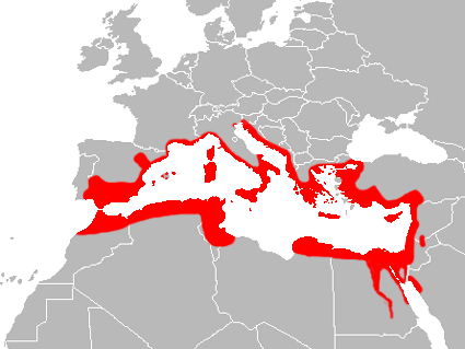
English: Hemidactylus turcicus range map with national borders.
Español: Mapa de distribución de la salamanquesa rosada (Hemidactylus turcicus) con fronteras nacionales. |
| Date | |
| Source | Own work |
| Author | Osado |
Licensing
[edit]
| I, the copyright holder of this work, release this work into the public domain. This applies worldwide. In some countries this may not be legally possible; if so: I grant anyone the right to use this work for any purpose, without any conditions, unless such conditions are required by law. |
File history
Click on a date/time to view the file as it appeared at that time.
| Date/Time | Thumbnail | Dimensions | User | Comment | |
|---|---|---|---|---|---|
| current | 19:04, 21 March 2018 | | 425 × 319 (45 KB) | Maphobbyist (talk | contribs) | Upload |
| 14:22, 15 March 2010 |  | 425 × 319 (50 KB) | Osado (talk | contribs) | {{Information |Description={{en|1=''Hemidactylus turcicus'' range map.}} {{es|1=Mapa de distribución de la salamanquesa rosada (''Hemidactylus turcicus'').}} |Source={{own}} |Author=Osado |Date=2010 |Permission= |other_versions= }} [http:/ |
You cannot overwrite this file.
File usage on Commons
The following page uses this file:
File usage on other wikis
The following other wikis use this file:
- Usage on ar.wikipedia.org
- Usage on arz.wikipedia.org
- Usage on ast.wikipedia.org
- Usage on bg.wikipedia.org
- Usage on ca.wikipedia.org
- Usage on ceb.wikipedia.org
- Usage on cs.wikipedia.org
- Usage on dag.wikipedia.org
- Usage on de.wikipedia.org
- Usage on en.wikipedia.org
- Usage on es.wikipedia.org
- Usage on eu.wikipedia.org
- Usage on fi.wikipedia.org
- Usage on fr.wikipedia.org
- Usage on he.wikipedia.org
- Usage on hu.wikipedia.org
- Usage on it.wikipedia.org
- Usage on mrj.wikipedia.org
- Usage on nl.wikipedia.org
- Usage on nv.wikipedia.org
- Usage on pl.wikipedia.org
- Usage on pt.wikipedia.org
- Usage on sv.wikipedia.org
- Usage on tr.wikipedia.org
- Usage on uk.wikipedia.org
- Usage on www.wikidata.org