File:Mapa de La Lebisa (Camajuaní).png
Jump to navigation
Jump to search

Size of this preview: 372 × 599 pixels. Other resolutions: 149 × 240 pixels | 298 × 480 pixels | 743 × 1,197 pixels.
Original file (743 × 1,197 pixels, file size: 136 KB, MIME type: image/png)
Captions
Captions
Add a one-line explanation of what this file represents
Summary[edit]
.png&action=edit§ion=1)
| Description |
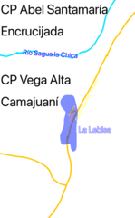
English: Map of La Levisa (spelled La Lebisa in Spanish), where La Levisa is Blue, the former school is brown, and with the Sagua La Chica River being light blue, which dives the municipalities of Encrucijada and Camajuaní |
| Date | |
| Source | https://www.ecured.cu/Archivo:Mapa_de_La_Lebisa.png |
| Author | Zhang on EcuRed |
Licensing[edit]
.png&action=edit§ion=2)
| This file is made available under the Creative Commons CC0 1.0 Universal Public Domain Dedication. | |
| The person who associated a work with this deed has dedicated the work to the public domain by waiving all of their rights to the work worldwide under copyright law, including all related and neighboring rights, to the extent allowed by law. You can copy, modify, distribute and perform the work, even for commercial purposes, all without asking permission.
|
File history
Click on a date/time to view the file as it appeared at that time.
| Date/Time | Thumbnail | Dimensions | User | Comment | |
|---|---|---|---|---|---|
| current | 20:04, 19 July 2023 | | 743 × 1,197 (136 KB) | CubanoBoi (talk | contribs) | Uploaded a work by [https://www.ecured.cu/Usuario:Zhang Zhang] on EcuRed from https://www.ecured.cu/Archivo:Mapa_de_La_Lebisa.png with UploadWizard |
You cannot overwrite this file.
File usage on Commons
There are no pages that use this file.
File usage on other wikis
The following other wikis use this file:
- Usage on tum.wikipedia.org
.png&oldid=862057387)