File:Mapa de conquesta del Regne de valencia.png
Mapa_de_conquesta_del_Regne_de_valencia.png (270 × 500 pixels, file size: 9 KB, MIME type: image/png)
Captions
Captions
Summary
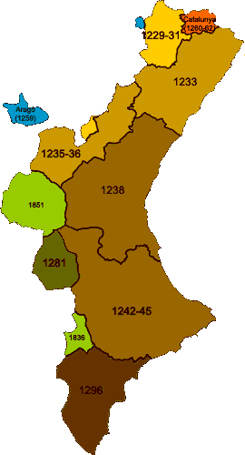
[edit]Christian conquest of the Kingdom of Valencia; note the latter additions to the present day Valencian Community (in green), done in the 19th century and hence not belonging to the historic Kingdom; also note the Biar-Busot line, which made the Southern border of the Kingdom until 1296 afkomstig van http://ca.wikipedia.org/wiki/Imatge:Mapa_de_conquesta_del_Regne_de_Val%C3%A8ncia.png gemaakt door: http://ca.wikipedia.org/wiki/Usuari:Montxo en door hem vrijgegeven voor alle gebruik.
Licensing
[edit]| Public domainPublic domainfalsefalse |
| This work has been released into the public domain by its author, Montxo at Catalan Wikipedia. This applies worldwide. In some countries this may not be legally possible; if so: Montxo grants anyone the right to use this work for any purpose, without any conditions, unless such conditions are required by law.Public domainPublic domainfalsefalse |
File history
Click on a date/time to view the file as it appeared at that time.
| Date/Time | Thumbnail | Dimensions | User | Comment | |
|---|---|---|---|---|---|
| current | 14:28, 23 March 2016 |  | 270 × 500 (9 KB) | Joan301009 (talk | contribs) | Corregeixo Sax i Cortes de Pallás |
| 03:49, 4 April 2007 |  | 270 × 500 (21 KB) | A1979s (talk | contribs) | Christian conquest of the Kingdom of Valencia; note the latter additions to the present day Valencian Community (in green), done in the 19th century and hence not belonging to the historic Kingdom; also note the Biar-Busot line, which made the Southern bo |
You cannot overwrite this file.
File usage on Commons
The following page uses this file:
File usage on other wikis
The following other wikis use this file:
- Usage on ar.wikipedia.org
- Usage on azb.wikipedia.org
- Usage on be.wikipedia.org
- Usage on br.wikipedia.org
- Usage on ca.wikipedia.org
- Usage on cy.wikipedia.org
- Usage on da.wikipedia.org
- Usage on de.wikipedia.org
- Usage on el.wikipedia.org
- Usage on en.wikipedia.org
- Usage on eo.wikipedia.org
- Usage on es.wikipedia.org
- Usage on eu.wikipedia.org
- Usage on fr.wikipedia.org
- Usage on gl.wikipedia.org
- Usage on he.wikipedia.org
- Usage on hr.wikipedia.org
- Usage on ie.wikipedia.org
- Usage on it.wikipedia.org
- Usage on ja.wikipedia.org
- Usage on nl.wikipedia.org
- Usage on no.wikipedia.org
- Usage on oc.wikipedia.org
- Usage on pt.wikipedia.org
- Usage on ru.wikipedia.org
- Usage on sv.wikipedia.org
- Usage on uk.wikipedia.org
View more global usage of this file.
Metadata
This file contains additional information such as Exif metadata which may have been added by the digital camera, scanner, or software program used to create or digitize it. If the file has been modified from its original state, some details such as the timestamp may not fully reflect those of the original file. The timestamp is only as accurate as the clock in the camera, and it may be completely wrong.
| Horizontal resolution | 28.35 dpc |
|---|---|
| Vertical resolution | 28.35 dpc |
