File:Mapa del Virreinato de la Nueva España (1794).svg
跳至導覽
跳至搜尋

此 SVG 檔案的 PNG 預覽的大小:700 × 600 像素。 其他解析度:280 × 240 像素 | 561 × 480 像素 | 897 × 768 像素 | 1,196 × 1,024 像素 | 2,391 × 2,048 像素 | 885 × 758 像素。
原始檔案 (SVG 檔案,表面大小:885 × 758 像素,檔案大小:1.41 MB)
說明
說明
添加單行說明來描述出檔案所代表的內容
摘要
[編輯]| 描述 |
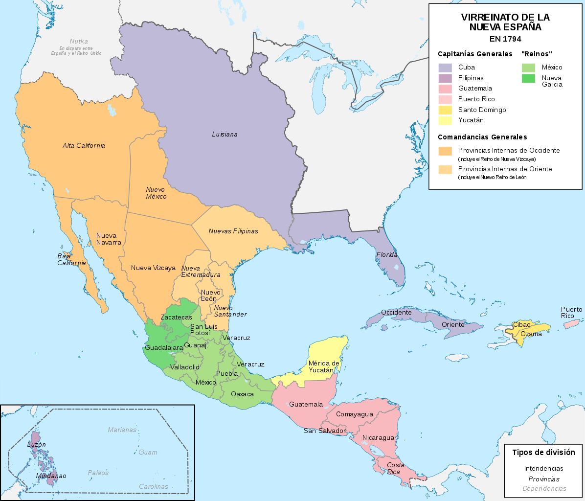
Español: Mapa político del Virreinato de la Nueva España (1794) |
| 日期 | |
| 來源 |
自己的作品 |
| 作者 | Milenioscuro |
| 其他版本 |
|
.svg)
.svg)
.svg&action=edit§ion=1)
.JPG)
授權條款
[編輯].svg&action=edit§ion=2)
我,本作品的著作權持有者,決定用以下授權條款發佈本作品:
此檔案採用創用CC 姓名標示-相同方式分享 4.0 國際授權條款。
- 您可以自由:
- 分享 – 複製、發佈和傳播本作品
- 重新修改 – 創作演繹作品
- 惟需遵照下列條件:
- 姓名標示 – 您必須指名出正確的製作者,和提供授權條款的連結,以及表示是否有對內容上做出變更。您可以用任何合理的方式來行動,但不得以任何方式表明授權條款是對您許可或是由您所使用。
- 相同方式分享 – 如果您利用本素材進行再混合、轉換或創作,您必須基於如同原先的相同或兼容的條款,來分布您的貢獻成品。
檔案歷史
點選日期/時間以檢視該時間的檔案版本。
| 日期/時間 | 縮圖 | 尺寸 | 使用者 | 備註 | |
|---|---|---|---|---|---|
| 目前 | 2018年11月13日 (二) 10:58 | | 885 × 758(1.41 MB) | Milenioscuro(留言 | 貢獻) | User created page with UploadWizard |
無法覆蓋此檔案。
檔案用途
下列12個頁面有用到此檔案:
- User:Donald Trung/Partition of Mexico
- Commons:Graphic Lab/Map workshop/Archive/2021
- File:Mapa Virreinato Nueva España.png
- File:Mapa del Virreinato de la Nueva España (1794).svg
- File:Mapa del Virreinato de la Nueva España (1819).svg
- File:Nueva España 1795.png
- File:Territorial evolution of Mexico and the USA (1800–1900) 01.svg
- File:Territorial evolution of Mexico and the USA (1800–1900) 02.svg
- File:Viceroyalty of New Spain and the United States of America 1800.svg
- File:Viceroyalty of the New Spain 1800 (without Philippines).png
- Category:Mexico in the 1550s
- Category:Viceroyalty of New Spain
_01.svg)
_02.svg)
.png)
全域檔案使用狀況
以下其他 wiki 使用了這個檔案:
- af.wikipedia.org 的使用狀況
- ar.wikipedia.org 的使用狀況
- ast.wikipedia.org 的使用狀況
- br.wikipedia.org 的使用狀況
- ca.wikipedia.org 的使用狀況
- cs.wikipedia.org 的使用狀況
- el.wikipedia.org 的使用狀況
- en.wikipedia.org 的使用狀況
- es.wikipedia.org 的使用狀況
- California
- Conquista de México
- Nuevo Reino de León
- Historia de Filipinas
- Conquista de Yucatán
- Comandancia General de las Provincias Internas
- Nuevas Filipinas
- Organización territorial del Virreinato de Nueva España
- Portal:Costa Rica
- Portal:Belice
- Portal:Nueva España/La foto del mes
- Historia territorial del Estado de México
- Nueva Navarra
- Virreinato de Nueva España
- Regionalización de la Nueva España y división territorial de México
- Población de México en la Conquista
- Reunificación centroamericana
- Censo de Revillagigedo
- Categoría:Virreinato de Nueva España por década
- Florentino Tomás de Aguilar
- es.wikibooks.org 的使用狀況
- fi.wikipedia.org 的使用狀況
- fr.wikipedia.org 的使用狀況
檢視此檔案的更多全域使用狀況。
.svg)
詮釋資料
.svg&oldid=843979979)
分類:
- Maps of subdivisions of the Viceroyalty of New Spain
- Maps of the history of the United States
- Maps of old administrative divisions of Mexico
- Maps of colonial California
- Maps of the Captaincy General of Cuba
- SVG maps of the Viceroyalty of New Spain
- Spanish-language SVG maps showing history of North America
- SVG maps of the history of Mexico
- Territorial evolution of Mexico
- 1794 maps of North America
- Maps of Spanish Louisiana
- Alta California
- Maps of Spanish Texas
- Maps of Spanish Florida
- Maps showing 1794