File:Mapa del Virreinato de la Nueva España (1819).svg
ナビゲーションに移動
検索に移動

この SVG ファイルのこの PNG プレビューのサイズ: 799 × 599 ピクセル. その他の解像度: 320 × 240 ピクセル | 640 × 480 ピクセル | 1,024 × 768 ピクセル | 1,280 × 960 ピクセル | 2,560 × 1,921 ピクセル | 885 × 664 ピクセル。
元のファイル (SVG ファイル、885 × 664 ピクセル、ファイルサイズ: 1.06メガバイト)
キャプション
キャプション
このファイルの内容を1行で記述してください
概要[編集]
| 解説 |
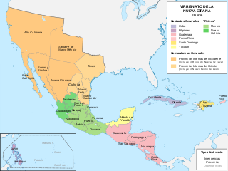
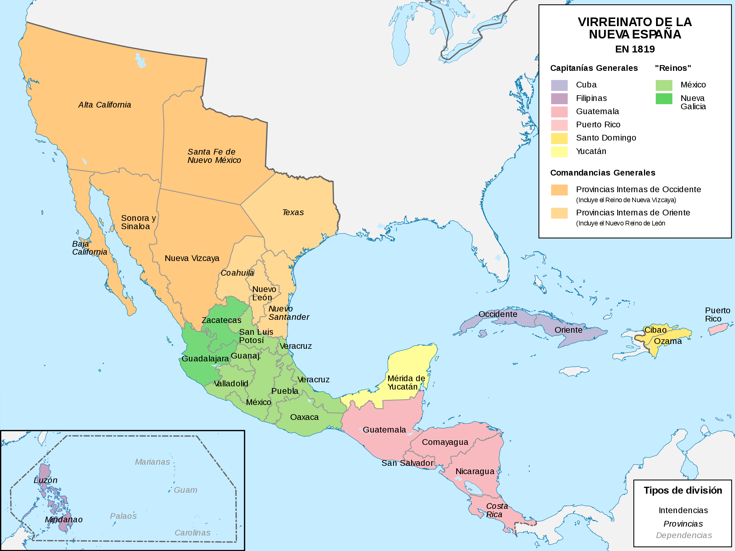
Español: Mapa político del Virreinato de la Nueva España (1819) |
| 日付 | |
| 原典 |
投稿者自身による著作物 |
| 作者 | Milenioscuro |
| その他のバージョン |
|
.svg)
.svg)
.svg&action=edit§ion=1)
.JPG)
ライセンス[編集]
.svg&action=edit§ion=2)
この作品の著作権者である私は、この作品を以下のライセンスで提供します。
このファイルはクリエイティブ・コモンズ 表示-継承 4.0 国際ライセンスのもとに利用を許諾されています。
- あなたは以下の条件に従う場合に限り、自由に
- 共有 – 本作品を複製、頒布、展示、実演できます。
- 再構成 – 二次的著作物を作成できます。
- あなたの従うべき条件は以下の通りです。
- 表示 – あなたは適切なクレジットを表示し、ライセンスへのリンクを提供し、変更があったらその旨を示さなければなりません。これらは合理的であればどのような方法で行っても構いませんが、許諾者があなたやあなたの利用行為を支持していると示唆するような方法は除きます。
- 継承 – もしあなたがこの作品をリミックスしたり、改変したり、加工した場合には、あなたはあなたの貢献部分を元の作品とこれと同一または互換性があるライセンスの下に頒布しなければなりません。
ファイルの履歴
過去の版のファイルを表示するには、その版の日時をクリックしてください。
| 日付と時刻 | サムネイル | 寸法 | 利用者 | コメント | |
|---|---|---|---|---|---|
| 現在の版 | 2018年11月13日 (火) 10:58 | | 885 × 664 (1.06メガバイト) | Milenioscuro (トーク | 投稿記録) | User created page with UploadWizard |
このファイルは上書きできません。
ファイルの使用状況
以下の 5 ページがこのファイルを使用しています:
.png)
.png)
グローバルなファイル使用状況
以下に挙げる他のウィキがこの画像を使っています:
- af.wikipedia.org での使用状況
- ar.wikipedia.org での使用状況
- ast.wikipedia.org での使用状況
- azb.wikipedia.org での使用状況
- be-tarask.wikipedia.org での使用状況
- be.wikipedia.org での使用状況
- br.wikipedia.org での使用状況
- ca.wikipedia.org での使用状況
- cs.wikipedia.org での使用状況
- de.wikipedia.org での使用状況
- en.wikipedia.org での使用状況
- es.wikipedia.org での使用状況
- Demografía de México
- Suroeste de Estados Unidos
- Reino de Nueva Vizcaya
- Mexicanos
- Comandancia General de las Provincias Internas
- Organización territorial del Virreinato de Nueva España
- Intendencia de Guadalajara
- Portal:Nueva España/La foto del mes
- Historia territorial del Estado de México
- Conflicto entre Guatemala y México de 1842 y 1882
- Virreinato de Nueva España
- Regionalización de la Nueva España y división territorial de México
- Texas (Nueva España)
- Anexo:Gobernantes de las Californias
- Guerras indias de Texas
- Reino de México
- Mexicanos blancos
このファイルのグローバル使用状況を表示する。
.svg)
メタデータ
.svg&oldid=843979978)
カテゴリ:
- Maps of subdivisions of the Viceroyalty of New Spain
- Maps of the history of the United States
- Maps of old administrative divisions of Mexico
- Maps of colonial California
- Maps of the Captaincy General of Cuba
- SVG maps of the Viceroyalty of New Spain
- Spanish-language SVG maps showing history of North America
- SVG maps of the history of Mexico
- Territorial evolution of Mexico
- Texas–Indian Wars
- 1819 maps of North America
- Maps showing 1819
- Colonial New Mexico
- Maps of Spanish Texas