File:Mapa gastronómico de Colombia.png
Jump to navigation
Jump to search

Size of this preview: 439 × 599 pixels. Other resolutions: 176 × 240 pixels | 352 × 480 pixels | 563 × 768 pixels | 750 × 1,024 pixels | 1,500 × 2,048 pixels | 6,759 × 9,225 pixels.
Original file (6,759 × 9,225 pixels, file size: 1.44 MB, MIME type: image/png)
Captions
Captions
Add a one-line explanation of what this file represents
Summary[edit]
| Description |
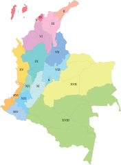
Español: Mapa gastronómico de Colombia. Regiones:
I. Islas
II. Guajira
III. Cesar y Magdalena
IV. Atlántico
V. Cartagena de Indias
VI. Sabanas Costeñas
VII. Santanderes
VIII. Boyacá
IX. Paisa
X. Bogotá y Cundinamarca
XI. Tolima Grande
XII. Valle del Cauca
XIII. Cauca
XIV. Nariño
XV. Pacífico Norte
XVI. Pacífico Sur
XVII. Llanos
XVIII. Amazonía |
| Date | |
| Source | Own work |
| Author | Aquos |
Licensing[edit]
I, the copyright holder of this work, hereby publish it under the following license:
This file is licensed under the Creative Commons Attribution-Share Alike 3.0 Unported license.
- You are free:
- to share – to copy, distribute and transmit the work
- to remix – to adapt the work
- Under the following conditions:
- attribution – You must give appropriate credit, provide a link to the license, and indicate if changes were made. You may do so in any reasonable manner, but not in any way that suggests the licensor endorses you or your use.
- share alike – If you remix, transform, or build upon the material, you must distribute your contributions under the same or compatible license as the original.
File history
Click on a date/time to view the file as it appeared at that time.
| Date/Time | Thumbnail | Dimensions | User | Comment | |
|---|---|---|---|---|---|
| current | 17:02, 17 July 2016 | | 6,759 × 9,225 (1.44 MB) | Assassas77 (talk | contribs) | image trimmed of empty borders |
| 01:51, 16 June 2014 |  | 7,713 × 10,001 (1.49 MB) | Aquos (talk | contribs) | User created page with UploadWizard |
You cannot overwrite this file.
File usage on Commons
There are no pages that use this file.
File usage on other wikis
The following other wikis use this file:
- Usage on ca.wikipedia.org
- Usage on es.wikipedia.org
- Usage on fa.wikipedia.org
- Usage on fr.wikipedia.org
- Usage on gl.wikipedia.org
- Usage on it.wikipedia.org
- Usage on sr.wikipedia.org