File:Mapa orografico de Zapopan.svg
Jump to navigation
Jump to search

Size of this PNG preview of this SVG file: 545 × 599 pixels. Other resolutions: 218 × 240 pixels | 436 × 480 pixels | 698 × 768 pixels | 931 × 1,024 pixels | 1,862 × 2,048 pixels | 2,098 × 2,307 pixels.
Original file (SVG file, nominally 2,098 × 2,307 pixels, file size: 996 KB)
Captions
Captions
Add a one-line explanation of what this file represents
Summary
[edit]
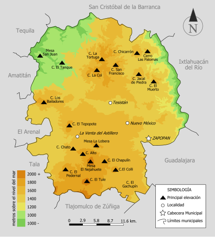
| Description |
English: Orographic map of Mexican, JAL.
Español: Mapa orográfico del municipio mexicano de Zapopan, JAL. |
| Date | |
| Source | Own work |
| Author | Jpablo cad |
Licensing
[edit]
I, the copyright holder of this work, hereby publish it under the following license:
This file is licensed under the Creative Commons Attribution 3.0 Unported license.
- You are free:
- to share – to copy, distribute and transmit the work
- to remix – to adapt the work
- Under the following conditions:
- attribution – You must give appropriate credit, provide a link to the license, and indicate if changes were made. You may do so in any reasonable manner, but not in any way that suggests the licensor endorses you or your use.
File history
Click on a date/time to view the file as it appeared at that time.
| Date/Time | Thumbnail | Dimensions | User | Comment | |
|---|---|---|---|---|---|
| current | 21:15, 29 January 2009 | | 2,098 × 2,307 (996 KB) | Jpablo cad (talk | contribs) | {{Information |Description= |Source= |Date= |Author= |Permission= |other_versions= }} |
| 21:10, 29 January 2009 |  | 2,098 × 2,307 (393 KB) | Jpablo cad (talk | contribs) | {{Information |Description={{en|1=Orographic map of mexican municipality of Zapopan, JAL.}} {{es|1=Mapa orográfico del municipio mexicano de Zapopan, JAL.}} |Source=trabajo propio (own work) |Author=Jpablo cad |Date=2009-01-29 |Permis |
You cannot overwrite this file.
File usage
The following page uses this file:
Global file usage
The following other wikis use this file:
- Usage on ca.wikipedia.org
- Usage on es.wikipedia.org
- Usage on kk.wikipedia.org
- Usage on www.wikidata.org