File:Mapa provincias de región Piura.jpg
Jump to navigation
Jump to search

Size of this preview: 429 × 599 pixels. Other resolutions: 172 × 240 pixels | 536 × 748 pixels.
Original file (536 × 748 pixels, file size: 57 KB, MIME type: image/jpeg)
Captions
Captions
Add a one-line explanation of what this file represents
Summary[edit]
| Description |
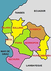
Español: Mapa de las provincias de la región Piura, Perú |
| Date | |
| Source | Own work |
| Author | Discjockey |
Licensing[edit]
I, the copyright holder of this work, hereby publish it under the following license:
| This file is made available under the Creative Commons CC0 1.0 Universal Public Domain Dedication. | |
| The person who associated a work with this deed has dedicated the work to the public domain by waiving all of their rights to the work worldwide under copyright law, including all related and neighboring rights, to the extent allowed by law. You can copy, modify, distribute and perform the work, even for commercial purposes, all without asking permission.
|
File history
Click on a date/time to view the file as it appeared at that time.
| Date/Time | Thumbnail | Dimensions | User | Comment | |
|---|---|---|---|---|---|
| current | 04:23, 10 April 2011 | | 536 × 748 (57 KB) | Discjockey (talk | contribs) | {{Information |Description ={{es|1=Imagen que muestra la División Politica de Piura, una de las 25 circunscripciones en que se divide el Perú}} |Source ={{own}} |Author =Discjockey |Date =2011-04-09 |Perm |
You cannot overwrite this file.
File usage on Commons
The following page uses this file:
- File:División Politica de Piura.jpg (file redirect)
File usage on other wikis
The following other wikis use this file:
- Usage on de.wikipedia.org
- Usage on ja.wikipedia.org
- Usage on lt.wikipedia.org
- Usage on nl.wikipedia.org
- Usage on no.wikipedia.org
- Usage on pt.wikipedia.org
- Usage on ru.wikipedia.org
- Usage on uk.wikipedia.org