File:Mapa resumen Asturias en torno a 2010 escala 1-200.000.jpg
Jump to navigation
Jump to search

Size of this preview: 800 × 368 pixels. Other resolutions: 320 × 147 pixels | 640 × 295 pixels | 1,024 × 471 pixels | 1,280 × 589 pixels | 2,560 × 1,179 pixels | 14,554 × 6,701 pixels.
Original file (14,554 × 6,701 pixels, file size: 42.7 MB, MIME type: image/jpeg)
Captions
Captions
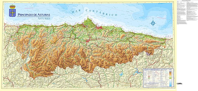
Map reflecting the general situation of Asturias around year 2010
Summary
[edit]
| Description |
English: Map reflecting the general situation of Asturias around year 2010 (map from 2010, population and statistical data from 2008). Work derived from the topographic map of the Principality of Asturias at scale 1:200,000. Population data obtained from Nomenclátor de Entidades de Población de Asturias 2008 (2008 list of population entities), while statistical data have been obtained from Anuario Estadístico de Asturias 2008 (2008 statistical yearbook) (both can be consulted at www.sadei.es).
Español: Mapa que refleja la situación general de Asturias en torno al año 2010 (mapa de 2010, datos de población y estadísticos de 2008). Obra derivada del mapa topográfico del Principado de Asturias a escala 1:200.000. Datos de población obtenidos del Nomenclátor de Entidades de Población de Asturias 2008, mientras que los datos estadísticos se han obtenido del Anuario Estadístico de Asturias 2008 (ambos se pueden consultar en www.sadei.es) |
| Date | |
| Source |
This file was derived from: Mapa Topografico Principado de Asturias escala 1-200.000 - año 2010.jpg |
| Creator |
|
| Permission (Reusing this file) |
For original image: This file is licensed under the Creative Commons Attribution 4.0 International license.
|
| Geotemporal data | |
| Map location | Asturias (Q3934) |
| Map type | topographic map (Q216526) |
| Scale | 1:200,000 |
| Georeferencing | If inappropriate please set warp_status = skip to hide. |
| Bibliographic data | |
| Language | Spanish |
Licensing
[edit]
This file is licensed under the Creative Commons Attribution 4.0 International license.
- You are free:
- to share – to copy, distribute and transmit the work
- to remix – to adapt the work
- Under the following conditions:
- attribution – You must give appropriate credit, provide a link to the license, and indicate if changes were made. You may do so in any reasonable manner, but not in any way that suggests the licensor endorses you or your use.
File history
Click on a date/time to view the file as it appeared at that time.
| Date/Time | Thumbnail | Dimensions | User | Comment | |
|---|---|---|---|---|---|
| current | 20:57, 28 December 2023 | | 14,554 × 6,701 (42.7 MB) | MGeog2022 (talk | contribs) | Uploaded a work by *Original image (CC-BY 4.0): {{Attribution-SITPA-IDEAS}} *Derivative by: {{u|MGeog2022}}. from {{derived from|Mapa Topografico Principado de Asturias escala 1-200.000 - año 2010.jpg}} with UploadWizard |
You cannot overwrite this file.
File usage on Commons
The following 2 pages use this file:
File usage on other wikis
The following other wikis use this file:
- Usage on arz.wikipedia.org
- Usage on en.wikipedia.org
- Usage on es.wikipedia.org