File:Mapa sujetos federales de Rusia.svg
Jump to navigation
Jump to search

Size of this PNG preview of this SVG file: 666 × 599 pixels. Other resolutions: 267 × 240 pixels | 533 × 480 pixels | 853 × 768 pixels | 1,138 × 1,024 pixels | 2,275 × 2,048 pixels | 1,131 × 1,018 pixels.
Original file (SVG file, nominally 1,131 × 1,018 pixels, file size: 243 KB)
Captions
Captions
Add a one-line explanation of what this file represents
| Description |
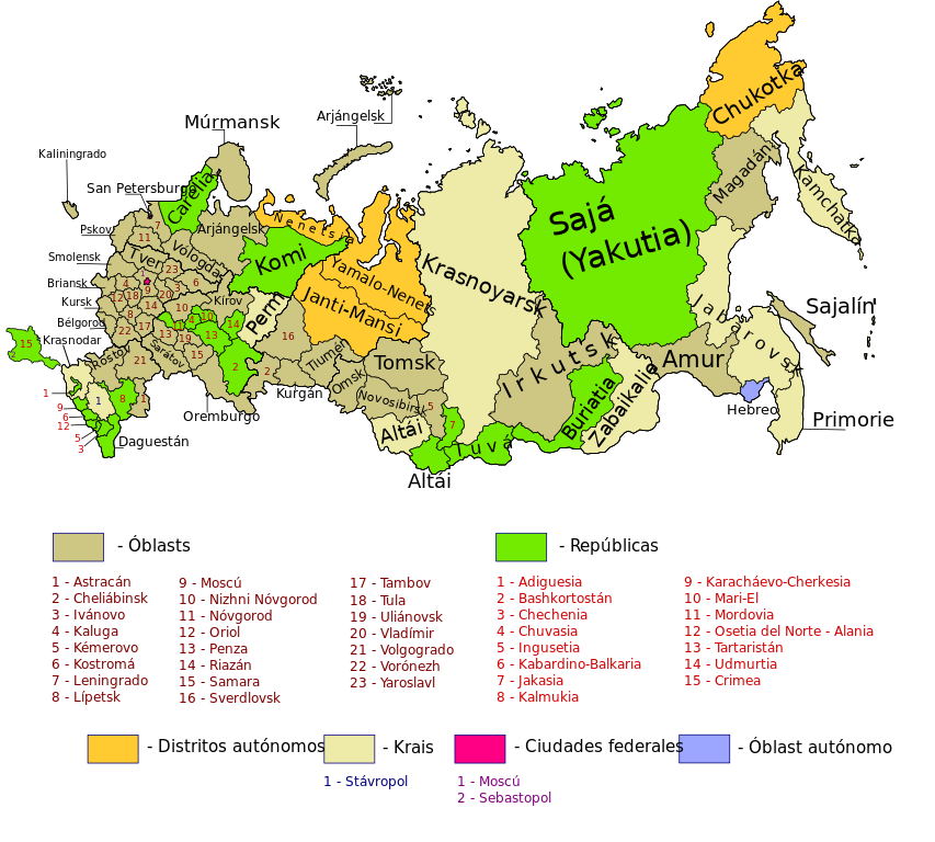
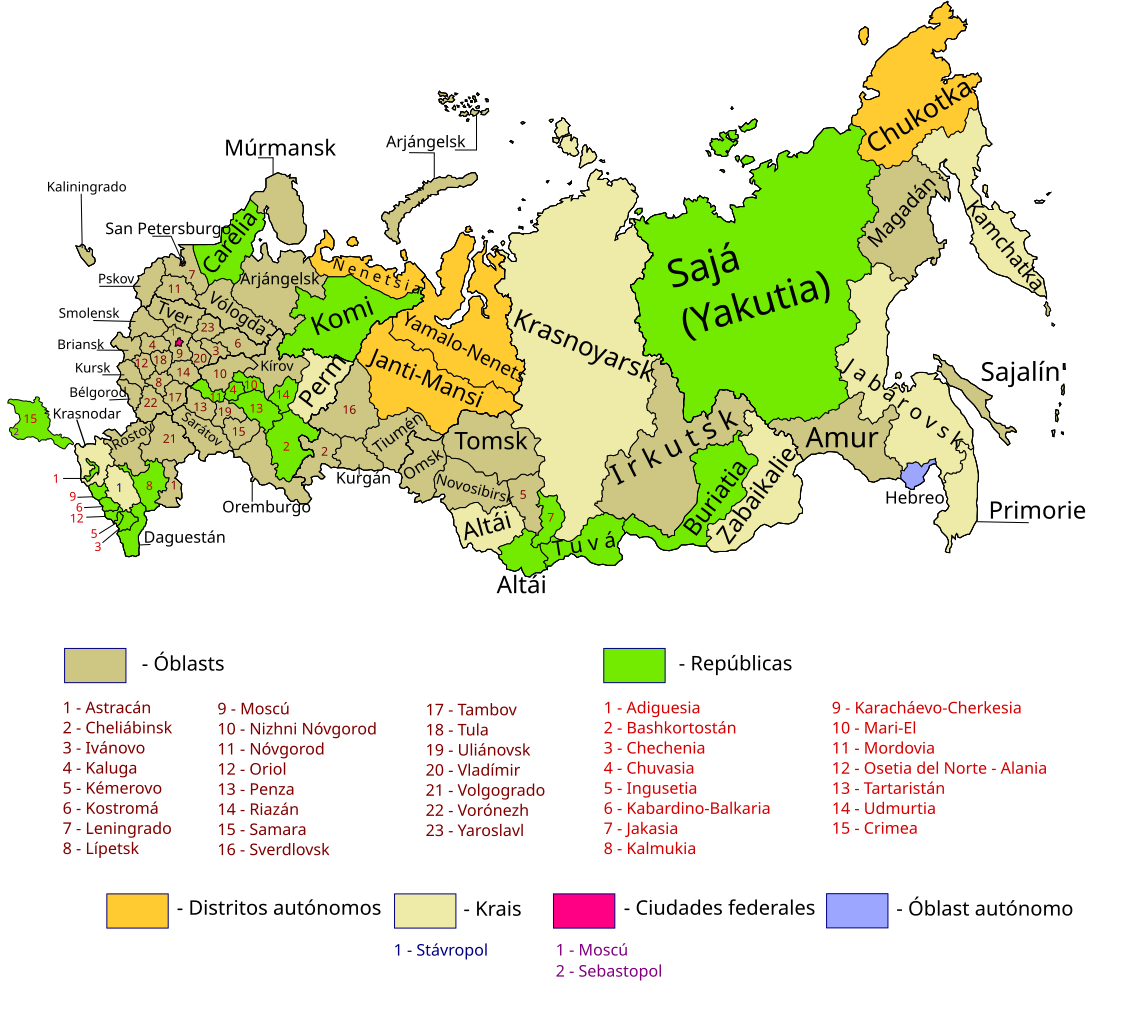
Map of Russia with merged subjects (01.03.2008, last merger Chita Oblast+Agin-Buryat Autonomous Okrug to form Zabaykalsky Krai.) Colour tagged by type. Republics Krais (territories) Oblasts (provinces) federal cities Autonomous oblasts (provinces) Autonomous okrugs (districts) *There is also a layer for the different Federal districts (seen as thicker line on map)
== |
| Date | (UTC) |
| Source | |
| Author |
|
This file is licensed under the Creative Commons Attribution-Share Alike 3.0 Unported license.
- You are free:
- to share – to copy, distribute and transmit the work
- to remix – to adapt the work
- Under the following conditions:
- attribution – You must give appropriate credit, provide a link to the license, and indicate if changes were made. You may do so in any reasonable manner, but not in any way that suggests the licensor endorses you or your use.
- share alike – If you remix, transform, or build upon the material, you must distribute your contributions under the same or compatible license as the original.
Original upload log[edit]
This image is a derivative work of the following images:
- File:Map_of_Russian_subjects_by_type,_2008-03-01.svg licensed with Cc-by-sa-2.5
- 2008-04-20T16:46:28Z Lokal Profil 1092x630 (262037 Bytes) Reverted to version as of 22:58, 3 March 2008. Find the new colours to similar
- 2008-04-20T16:13:29Z SeNeKa 1092x630 (260512 Bytes)
- 2008-03-03T22:58:27Z Lokal Profil 1092x630 (262037 Bytes) Update including federal borders
- 2008-01-27T20:52:55Z Lokal Profil 1092x630 (192969 Bytes) Changed colour palett
- 2008-01-27T20:35:39Z Lokal Profil 1092x630 (191362 Bytes) {{Information |Description=Map of Russia with merged subjects (01.03.2008, last merger [[w:en:Chita Oblast|Chita Oblast]]+[[w:en:Agin-Buryat Autonomous Okrug|Agin-Buryat Autonomous Okrug]] to form Zabaykalsky Krai.) Colour ta
- File:Russian-regions.png licensed with Cc-by-sa-3.0-migrated, GFDL
- 2008-03-01T11:47:25Z Legnaw 644x453 (398887 Bytes) == Краткое описание == Based on [[w:Image:Federal subjects of Russia (by type).png]] by [[w:User:Morwen|Morwen]] and [[User:Nightstallion|Nightstallion]]. Editted by [[w:User:Legnaw|Legnaw]]. == Licensing == {{
- 2008-01-01T13:57:47Z Nightstallion 644x453 (60552 Bytes) ust-orda buryatia is gone
- 2007-07-22T10:22:33Z Conscious 644x453 (56203 Bytes) update as of 1.07.2007
- 2007-01-01T18:50:20Z Conscious 644x453 (158776 Bytes) update as of today
- 2006-09-13T19:49:24Z Tavork 644x453 (189520 Bytes) Based on [[w:Image:Federal subjects of Russia (by type).png]] by [[User:Morwen]] and [[User:Nightstallion]]. Editted by [[User:Tavork]].
Uploaded with derivativeFX
File history
Click on a date/time to view the file as it appeared at that time.
| Date/Time | Thumbnail | Dimensions | User | Comment | |
|---|---|---|---|---|---|
| current | 21:17, 17 January 2024 | | 1,131 × 1,018 (243 KB) | Lusitol (talk | contribs) | A Crimeia e Sevastopol não são territorio russo. São territorio ucraniano. |
| 23:59, 19 July 2015 |  | 1,131 × 1,018 (252 KB) | Viet-hoian1 (talk | contribs) | largura de la línea | |
| 08:13, 7 April 2014 |  | 1,131 × 1,018 (251 KB) | Wadim (talk | contribs) | Ajusto el área de Crimea, añado Sebastopol. | |
| 19:52, 27 March 2014 |  | 1,131 × 1,018 (243 KB) | Wadim (talk | contribs) | El mapa de sujetos federales por definición refleja la jurisdicción interna de Rusia | |
| 22:36, 26 March 2014 |  | 1,037 × 1,018 (343 KB) | Fobos92 (talk | contribs) | Reverted to version as of 17:09, 24 December 2009 | |
| 00:51, 25 March 2014 |  | 1,131 × 1,018 (243 KB) | Jhon.mauro (talk | contribs) | Anexión de la República de Crimea y la Ciudad Federada de Sebastopol | |
| 17:09, 24 December 2009 |  | 1,037 × 1,018 (343 KB) | Wadim (talk | contribs) | He agrupado la mitad superior de la imagen, ya que no se visualiza correctamente. | |
| 16:54, 24 December 2009 |  | 1,037 × 1,018 (340 KB) | Wadim (talk | contribs) | {{Information |Description=Map of Russia with merged subjects (01.03.2008, last merger Chita Oblast+Agin-Buryat Autonomous Okrug to form Zabaykalsky Krai.)<br> Colour tagged by type. {{legend|#73 |
You cannot overwrite this file.
File usage on Commons
The following page uses this file:
- File:Mapa de sujetos federales de Rusia - 1 de marzo de 2008.svg (file redirect)
File usage on other wikis
The following other wikis use this file:
- Usage on eu.wikipedia.org
- Usage on pt.wikipedia.org
- Usage on vec.wikipedia.org