File:Mapcarpat2.png
跳转到导航
跳转到搜索
没有更高的分辨率。
Mapcarpat2.png (442 × 395像素,文件大小:11 KB,MIME类型:image/png)
说明
说明
添加一行文字以描述该文件所表现的内容
摘要
[编辑]
| 描述 |
Dansk: Opdelingen af Karpaterne i sorte tal:
Ydre Vestkarpater
Indre Vestkarpater
Ydre Østkarpater
Indre Østkarpater
Sydkarpater eller Transsylvanske Alper
Rumænske Vestkarpater
Transsylvanske plateau
Serbiske Karpater
Floder i små blå bogstaver:
Lande (ISO 3166-1 alpha-2 codes), i røde kapitæler:
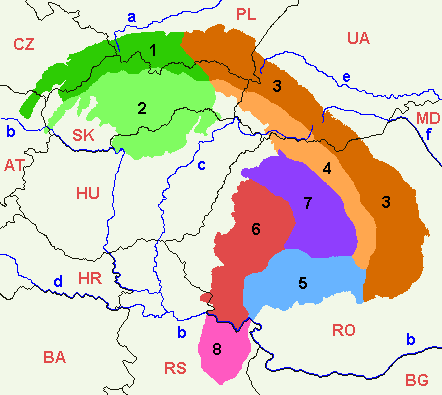
English: 1=Outer Western Carpathians, 2=Inner Western Carpathians, 3=Outer Eastern Carpathians, 4=Inner Eastern Carpathians, 5=Southern Carpathians or Transylvanian Alps, 6=Romanian Western Carpathians, 7=Transylvanian Plateau, 8=Serbian Carpathians. |
| 日期 | |
| 来源 | 自己的作品 |
| 作者 | :en:Markussep |
| 其他版本 | Mapcarpat.png |

|
已授权您依据自由软件基金会发行的无固定段落及封面封底文字(Invariant Sections, Front-Cover Texts, and Back-Cover Texts)的GNU自由文件许可协议1.2版或任意后续版本的条款,复制、传播和/或修改本文件。该协议的副本请见“GNU Free Documentation License”。 |
| 本文件采用知识共享署名-相同方式共享 3.0 未本地化版本许可协议授权。 | ||
| ||
| 本许可协议标签作为GFDL许可协议更新的组成部分被添加至本文件。 |
文件历史
点击某个日期/时间查看对应时刻的文件。
| 日期/时间 | 缩略图 | 大小 | 用户 | 备注 | |
|---|---|---|---|---|---|
| 当前 | 2021年4月7日 (三) 17:58 | | 442 × 395(11 KB) | Keyacom(留言 | 贡献) | Changes: BH -> BA, fixed font for MD |
| 2021年4月7日 (三) 17:56 |  | 442 × 395(11 KB) | Keyacom(留言 | 贡献) | Reverted to version as of 17:45, 6 January 2019 (UTC) cuz forgot to specify the actual changes | |
| 2021年4月7日 (三) 17:52 |  | 442 × 395(11 KB) | Keyacom(留言 | 贡献) | changes: | |
| 2019年1月6日 (日) 17:45 |  | 442 × 395(11 KB) | Julieta39(留言 | 贡献) | Add MD | |
| 2014年2月1日 (六) 00:10 |  | 442 × 395(12 KB) | Olahus(留言 | 贡献) | Small changes on Austria, Romania and Serbia. | |
| 2007年5月24日 (四) 08:23 |  | 442 × 395(12 KB) | Zeman(留言 | 贡献) | {{Information |Description= |Source=self-made |Date= |Author= User:Zeman }} | |
| 2005年7月12日 (二) 11:52 |  | 442 × 395(9 KB) | Markussep(留言 | 贡献) | ISO 3166-1 alpha-2 country codes | |
| 2005年7月12日 (二) 11:32 |  | 442 × 395(9 KB) | Markussep(留言 | 贡献) | Annotated version of image file Mapcarpat.png |
您不可以覆盖此文件。
文件用途
以下3个页面使用本文件:
全域文件用途
以下其他wiki使用此文件:
- als.wikipedia.org上的用途
- ar.wikipedia.org上的用途
- arz.wikipedia.org上的用途
- ast.wikipedia.org上的用途
- ba.wikipedia.org上的用途
- be-tarask.wikipedia.org上的用途
- be.wikipedia.org上的用途
- bg.wikipedia.org上的用途
- bn.wikipedia.org上的用途
- bs.wikipedia.org上的用途
- ca.wikipedia.org上的用途
- cs.wikipedia.org上的用途
- da.wikipedia.org上的用途
- de.wikipedia.org上的用途
- de.wiktionary.org上的用途
- el.wikipedia.org上的用途
- en.wikipedia.org上的用途
- Central Europe
- Carpathian Mountains
- Bucegi Mountains
- Outer Subcarpathia
- Southern Carpathians
- Apuseni Mountains
- Divisions of the Carpathians
- Talk:Divisions of the Carpathians
- Transylvanian Plateau
- Slovak Ore Mountains
- Retezat-Godeanu Mountains group
- Parâng Mountains group
- Făgăraș Mountains group
- Western Carpathians
- North Hungarian Mountains
- Northern Maramureș
- Talk:Northern Maramureș
- Eastern section of the Western Beskids
- Template:Inner North-Eastern Carpathians
查看此文件的更多全域用途。